An unseasonable warm airmass continues to be over region this afternoon. Clouds will mix with some sunshine and temperatures will be rising into middle to upper 60s and some lower 70s over many inland areas through middle of this afternoon. Closer the coast, moist south-southeast winds will keep more low clouds and temperatures cooler in the mid-upper 50s or lower 60s.
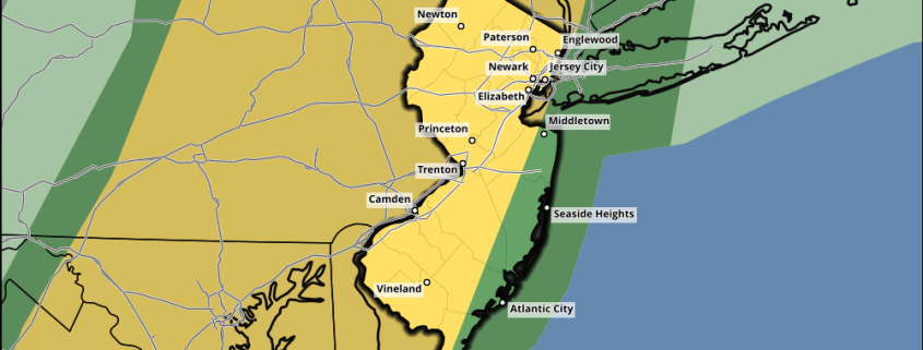
https://www.nymetroweather.com/wp-content/uploads/2017/02/NJ_swody1.png7501000Miguel Pierrehttps://www.nymetroweather.com/wp-content/uploads/2024/02/Empire-2000-x-300-px-2.pngMiguel Pierre2017-02-25 13:07:142017-02-25 13:09:24Public Analysis: Strong to Severe T-Storm Threat Late this Afternoon
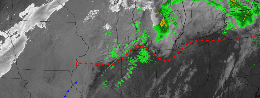
After some record warmth over the past few days, we are about to get our usual strong cold front “snap” back towards seasonable temperatures. But considering how warm and moist the atmosphere is initially, this means there will be quite an impressive temperature gradient, which is often a great fuel for storm development. Although the severe weather event in the Ohio Valley greatly underperformed (as expected), that does not necessarily portend an under-performer further east. While things do not necessarily lead to a major severe weather outbreak, the recent model guidance has actually trended a bit more impressive with a line of thunderstorms for late Saturday afternoon.
The reason this is happening is because there is a lot more backed low-level flow in our area compared to what the Ohio Valley had, meaning the surface winds are bending back to the southeast instead of the southwest. This adds more directional wind shear to the profile, considering winds just above the surface turn southwest — so that southeast to southwest turning with height provides some low-level rotation and thus a bit more organized updrafts. Additionally, there is a well-timed increase in the 850mb jet and lower just ahead of the strongest convection, allowing the line of thunderstorms to maintain its strength.
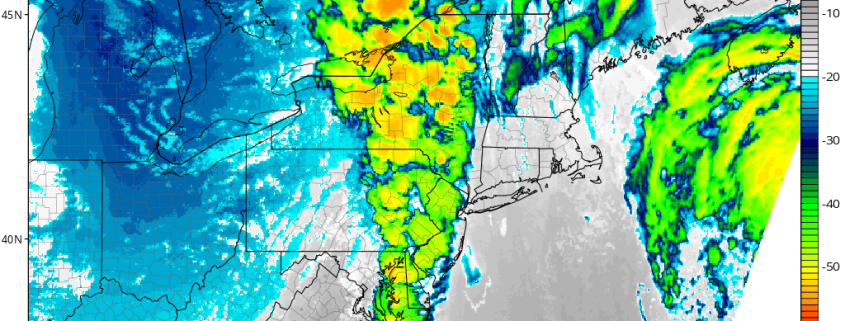
https://www.nymetroweather.com/wp-content/uploads/2017/02/nam3km_ir_neus_22.png7721024Doug Simonianhttps://www.nymetroweather.com/wp-content/uploads/2024/02/Empire-2000-x-300-px-2.pngDoug Simonian2017-02-25 07:00:032017-02-25 06:55:23Technical: Strong to Severe Thunderstorms Likely Late This Afternoon
Today has been yet another absolutely beautiful day with scattered clouds and light winds making for an excellent and unusual end to another February workweek. After a cold front and possible associated line of showers and thunderstorms move through tomorrow, a return to more seasonable temperatures is likely.
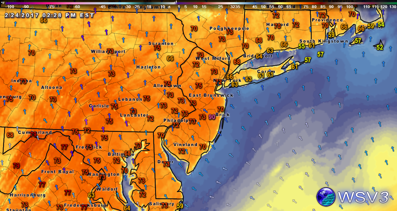
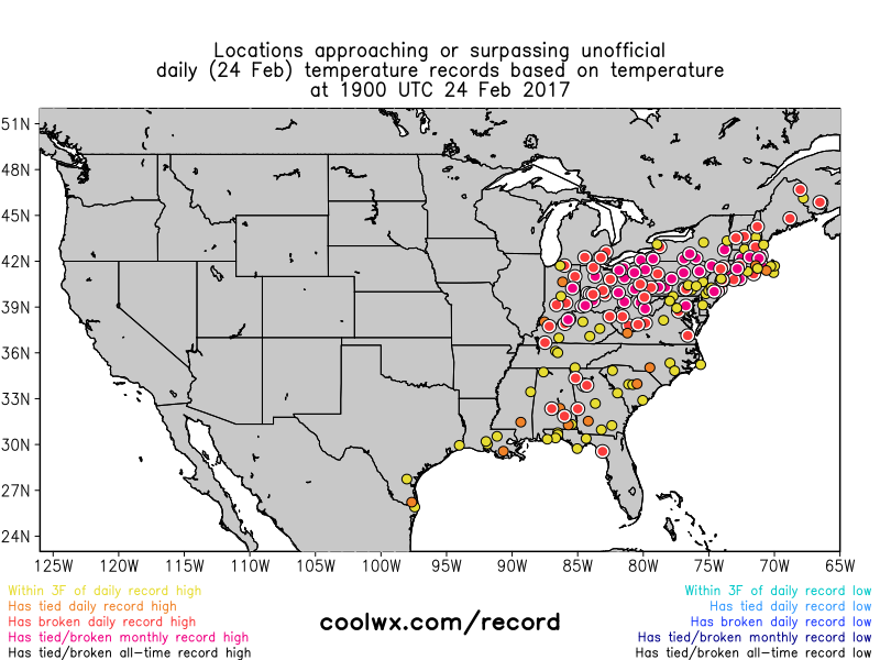
Temperatures this afternoon have soared into the low to mid 70’s across much of the area. with coastal locations along Long Island and Connecticut seeing temperatures a bit lower in the mid 60’s. As was mentioned as early as Monday, these temperatures are 25-35 degrees above normal for this time of year, and as a result, numerous monthly high temperature records are falling across the entire Northeast. All of this warmth has been caused by a high pressure system over the western Atlantic that continues to provide winds out of the southwest that will continue through this afternoon. As we progress through the afternoon and into the evening, the persistent ridging and attendant high pressure system will begin to give way to a stronger mid-level disturbance currently located over the central Plains this afternoon. (This system is also responsible for the marginal severe threat in the Ohio Valley this afternoon and evening-see our Severe Analysis for more on this event)
A look at the record-breaking temperatures across the metro area this afternoon
As the influence from this system increases later this evening, the amount of moisture available in the atmosphere will also increase. This low level moisture will become trapped underneath a temperature inversion, which will act as a “lid”, and enhance the possibility for some dense fog for coastal regions this evening and lasting into early tomorrow. This moisture should linger into the morning hours, with low level clouds and even some patchy drizzle taking place in the areas that have more available moisture to work with. As we move into Saturday afternoon, temperatures should not be as warm as today as winds from the southeast start to work into the metro and limit highs to the upper 60’s for inland locations and 50’s for the coast. Some locations that are stuck underneath prolonged low level clouds tomorrow afternoon will also struggle to really warm up too much tomorrow afternoon.
HRRR model showing limited surface visibility tomorrow morning due to low clouds and fog (Valid 7am)
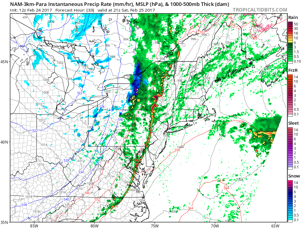
The main story tomorrow will be a cold front advancing eastward from the Ohio Valley and into Pennsylvania by tomorrow afternoon. Due to some limited instability as well as some lift provided by the upper level jet overspreading the area, a line of showers and thunderstorms will likely develop over Pennsylvania early tomorrow afternoon and quickly race eastward. As this line of thunderstorms reaches eastern Pennsylvania, southern New York, and New Jersey, what limited instability and dynamics that this line had to begin with will gradually fade. As a result, by the time the line of showers and thunderstorms reaches our area they should begin to weaken quite a bit. Heavy downpours, some brief gusty winds, and even some thunder are all possible, especially across inland zones.
3km NAM showing line of thunderstorms and associated showers along the cold front (Valid 3pm Saturday)
After the front moves through late tomorrow afternoon/evening, some lingering showers will be possible as temperatures begin to return to seasonable levels, and then even back down to below-normal temperatures by early Sunday morning. Although this below-normal period of temperatures appears to be short-lived, it should be quite the contrast from what we have seen over the past week or so. Once we get into the upcoming work week, temperatures should hover around normal to slightly above-normal with the chance for a few weak disturbances passing near our area to provide some precipitation for the area starting on Monday. This unsettled weather will continue for the rest of the week, but as we move on in time, long range guidance is beginning to indicate that the very fast flow that has prevented a few significant winter storms this season will begin to relax. This could possibly lead to at least some cooler weather and possibly a full return to winter by March. Make sure to stay tuned for updates on tomorrow’s possible heavy rain threat as well as the evolving long range pattern! For more information and posts like this one, make sure you sign up for Zone Forecasts — where multiple detailed articles, videos, and interactives are posted each day.
Have a great weekend!
https://www.nymetroweather.com/wp-content/uploads/2017/02/ne_2017022418.png8101260Steven Copertinohttps://www.nymetroweather.com/wp-content/uploads/2024/02/Empire-2000-x-300-px-2.pngSteven Copertino2017-02-24 15:44:172017-02-24 15:44:17Public Analysis: Record-breaking Warmth Gives Way To Seasonable Weather
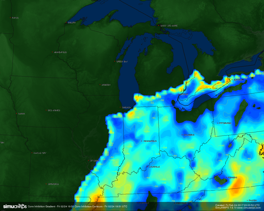
3:30pm Update: So far, everything is on track with respect to downplaying the event relative to SPCs and other outlooks’ expectations. As expected, there is still a lingering strong capping inversion in the warm sector, so there is not enough lift to generate strong thunderstorms to take advantage of the instability. Additionally, the low-level jet (LLJ) still continues to lag significantly behind the daytime heating, so the low-level winds are not strong enough for additional lift, superceullar organization, nor for transporting severe wind gusts down to the surface. There are only a few isolated wind reports so far, which is far below the threshold for an “enhanced” risk.
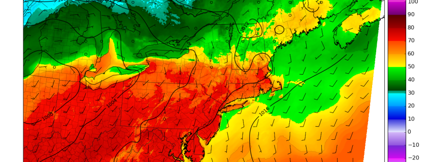
Current SIMUAWIPS analysis shows plenty of convective inhibition (CINH), preventing storms from taking full advantage of daytime heating.
We still do think that later this evening, when the storm system strengthens a bit and frontal forcing increases, we’ll get a decent low-level jet increase late this afternoon and through this evening, which may produce a strong to marginally severe line of storms along the cold front from eastern Indiana into Ohio. We still think Ohio may be more likely to see strong to severe winds since they are in the best location for an increase in the low-level jet. Some initially isolated discrete cells out ahead of the line may be able to produce some hail in Indiana and perhaps parts of Ohio, but the linear wind profiles indicate a transition to a line with moist mid-levels, so we do not expect many severe hail reports.
Additionally, the low-level jet is way too linear and weak right now to generate the necessary updraft helicity for tornadoes — which is why we never bought into a true tornado threat. There still may be some isolated tornado reports later this evening if some discrete cells can form ahead of the line of thunderstorms when the low-level jet does increase in strength. Fortunately, any tornado threat will be isolated and any tornado that does form should be weak.
Previous Content: During this early-spring…I mean late-winter day, the ingredients are beginning to come together for an impressive severe weather episode on Friday in the Ohio Valley. A strengthening storm system which will provide blizzard conditions for parts of the Northern Plains will have its warm sector line up perfectly with Gulf of Mexico moisture transport and instability. Furthermore, this strong storm system will be dragging a strong cold front to its east, helping to increase low-level moisture return via strong low-level winds from the Gulf of Mexico, provide plenty of lift via the frontal forcing, and also provide very cold mid-level temperatures. This is because behind the cold front, mid-level temperatures are very cold since there is actual winter-cold behind the front, but mid-level winds often blow so fast that they advect the mid-level cold air to places on the warm side/ahead of the cold front, helping to juxtapose a warm, moist airmass with cold air aloft and a lifting mechanism — perfect ingredients for thunderstorm formation. This cold air aloft and thus very strong thermodynamic and dynamic lifting with these types of systems this time of year often make up for not having a true summer-like low-level airmass and can provide lift equal to that of spring and summer-like outbreaks.
From here, the devil lies within the details as far as taking this severe weather episode from minor to major. At this point, we think this event will be somewhere in between. While the above details portend a significant outbreak, there are more nuances to this event, such as jet-streak behavior, as an alignment of strong jet streaks can turn lift from merely sufficient for thunderstorms, to majorly supportive. And what we see currently is a not ideal alignment of jet streaks in the low-levels and the upper-levels with when the storms actually initiate.
https://www.nymetroweather.com/wp-content/uploads/2017/02/simuawips-31.gif10241280Doug Simonianhttps://www.nymetroweather.com/wp-content/uploads/2024/02/Empire-2000-x-300-px-2.pngDoug Simonian2017-02-24 10:17:202017-02-24 15:28:13Enhanced Risk for Severe Weather in the Ohio Valley on Friday
Hi friends! Our website uses cookies to provide an optimal browsing experience for you. New "Cookie Consent" laws mandate us to inform you of this. As long as you're cool with it, just hit OK. You'll only see this message once.
We may request cookies to be set on your device. We use cookies to let us know when you visit our websites, how you interact with us, to enrich your user experience, and to customize your relationship with our website.
Click on the different category headings to find out more. You can also change some of your preferences. Note that blocking some types of cookies may impact your experience on our websites and the services we are able to offer.
Essential Website Cookies
These cookies are strictly necessary to provide you with services available through our website and to use some of its features.
Because these cookies are strictly necessary to deliver the website, refusing them will have impact how our site functions. You always can block or delete cookies by changing your browser settings and force blocking all cookies on this website. But this will always prompt you to accept/refuse cookies when revisiting our site.
We fully respect if you want to refuse cookies but to avoid asking you again and again kindly allow us to store a cookie for that. You are free to opt out any time or opt in for other cookies to get a better experience. If you refuse cookies we will remove all set cookies in our domain.
We provide you with a list of stored cookies on your computer in our domain so you can check what we stored. Due to security reasons we are not able to show or modify cookies from other domains. You can check these in your browser security settings.
Other external services
We also use different external services like Google Webfonts, Google Maps, and external Video providers. Since these providers may collect personal data like your IP address we allow you to block them here. Please be aware that this might heavily reduce the functionality and appearance of our site. Changes will take effect once you reload the page.
-2")
