NYC Area Forecast: Cool, transient weather ahead of potential weekend storm

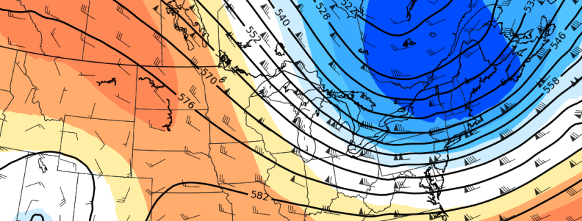
An active and colder weather pattern appears likely to continue for at least the next week, and it may be capped off with a large storm system as its grand finale this coming weekend. The pattern has been well advertised, and it arrived with some fanfare – a few strong cold fronts over the past few days have brought a myriad of hazardous weather to the Northeast states. Sunday featured the first real brisk, cold day in a while with a deep northwesterly flow and even a few lake effect snow/rain bands streaming into the Catskills.

Speaking of cold air, Freeze Warnings and Watches were in effect for fairly large majority of the region through Monday AM where the growing season had not yet ended – for many areas, it has now concluded. If you are in an area where it has not ended, or continue to leave plants outdoors, take care of sensitive vegetation – and yourself (bundle up!) during the next few days.

Read more

NYC Area Forecast: Freeze watches issued as coldest air of season arrives

The coldest air of the Autumn so far is set to arrive in the Northeast US later tonight through Thursday, as a piece of the polar vortex swings through New England. The anomalously cold airmass will only deliver a parting shot, but it will be sufficient to temporarily usher in the coldest air of the season to date. Temperatures will fall into the 20’s and 30’s throughout the Northeast states, with wind chill values in the 20’s even in the NYC Area.

The National Weather Service has issued Freeze Watches and Freeze Warnings for parts of the interior that have not yet received a hard freeze or ended their 2018 growing season. Blustery winds are expected to preclude or inhibit the formation of frost, but wind chill values in the 20’s will create harsh conditions for any remaining vegetation.

Read more

NYC Area Forecast: Colder, active pattern arrives late week

After a very warm start to Autumn, which featured temperature several degrees above normal essentially from late September through the middle of October, the weather pattern is set to change. You can thank the North Pacific Ocean for that – while just one of many factors responsible, it is a big one – as the large scale wave pattern (ridges, troughs, etc) is changing dramatically there. Eventually, these changes make their way toward the Lower 48.

Most notably, a large ridge is forecast to develop from the Pacific Northwest into British Columbia and other parts of Western Canada. The poleward reach of this ridge will be impressive and quite anomalous, with 500hPa (mid level) atmospheric heights running well above normal. As this ridge pushes northward, it will disrupt the higher latitude weather pattern, sending colder air surging further southward into Eastern Canada, the Great Lakes and Northeast.

Read more

The Weekender: On social media, a stormy pattern lies ahead

I’ll tell you what, I really needed a morning like this. Rain is steadily dripping on the windowsill, and it has been a gloomy (and slow) start to the morning. The coffee seems to taste a little better when I am able to enjoy a rainy morning like this. This weather has me reflecting back on the past week of weather – one that featured Hurricane Michael’s historic landfall in Florida.

More specifically, I started thinking about social media leading up the storm system and the way that meteorologists (and non-meteorologists) conveyed information.

Read more