Hurricane Michael a Category 4, still strengthening this morning

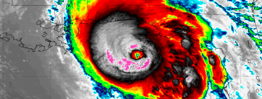
Update 8:15am: The National Hurricane Center says that Michael has strengthened again this morning, with maximum sustained winds now 145mph.

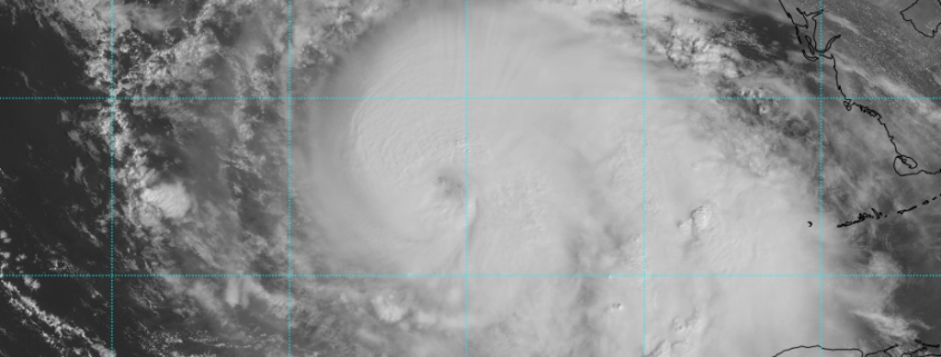
Hurricane Michael strengthened again overnight, and is now approaching the Florida Gulf Coast as a life-threatening Category Four hurricane with maximum sustained winds of 145mph.  The National Hurricane Center is now suggesting that the storm will make landfall as a Category Four hurricane with 145 mph sustained winds. No hurricane has ever hit the Florida Panhandle at such a strength. Records date back to 1851.

The strengthening of the storm overnight was feared by many forecasters and meteorologists as early as Tuesday afternoon, when the storm system began to appear more symmetric and approach warmer waters and lower shear. These conditions tend to promote increased organization and strength of tropical systems. The storm was still strengthening as of this morning, with a minimum central pressure down to 937hPa.

Read more

Hurricane Michael strengthens, aims toward Florida Gulf Coast

Hurricane Michael strengthened again this morning, reaching a Category 2 on the Saffir-Simpson scale with maximum sustained winds of 110mph. The storm also deepened to 965hPa as it continues to organize itself in the Southeastern Gulf of Mexico. The intensifying storm is predicted to make landfall on Wednesday as a Category 3 Major Hurricane, the most substantial hurricane threat for the Florida Gulf Coast in over a decade.

The National Hurricane Center suggests that Hurricane Michael will continue strengthening today as it encounters an increasingly favorable atmospheric environment. Lower wind shear and warmer waters of the Gulf of Mexico will promote increasing storm structure and strengthening wind speeds. Read more

Michael strengthening, damp and dreary weather continues

Monday has arrived without much fanfare – in fact, quite the opposite of fanfare. It has been dark, damp and dreary throughout the Northeast states and those conditions are largely expected to continue. You can thank low clouds and moisture trapped near the surface for that. We don’t expect the clouds to move much today, and drizzly conditions may very well continue through the evening hours as well.

The synoptic weather pattern doesn’t change all that much on Tuesday. Much of the Northeast will start the day with foggy conditions and drizzle, with temperatures still hovering in the upper 60’s and lower 70’s. It won’t be until the afternoon that higher pressures will begin to aid in some clearing, with some breaks of sun. Improving conditions are finally expected by Wednesday.

Read more

The Weekender: Tropical update, winter analog ideas

Happy Saturday folks. It has been a cloudy, somewhat drizzly start to the day in the Northeast and those conditions are generally expected to continue. Personally, I am enjoying the cloudy Autumn weather and a bit of relaxation – it has been a busy week for us and it has been great to take it a little slower this morning. While relaxing and slowly becoming less frustrated from last nights Yankees loss, I had the idea for The Weekender (which you are reading right now). Think of it as a lighthearted weather discussion on varying topics, meant for a casual weekend read.

Sometimes it will be more direct, other times it will be more casual. Sometimes I will probably complain about things in the industry or in the life of our company. Today, I wanted to open up some discussion on the potential development of a tropical cyclone in the Gulf of Mexico next week, and also touch on some of our Winter Forecast work without giving up too much information (that would really ruin the excitement, wouldn’t it?)

Read more