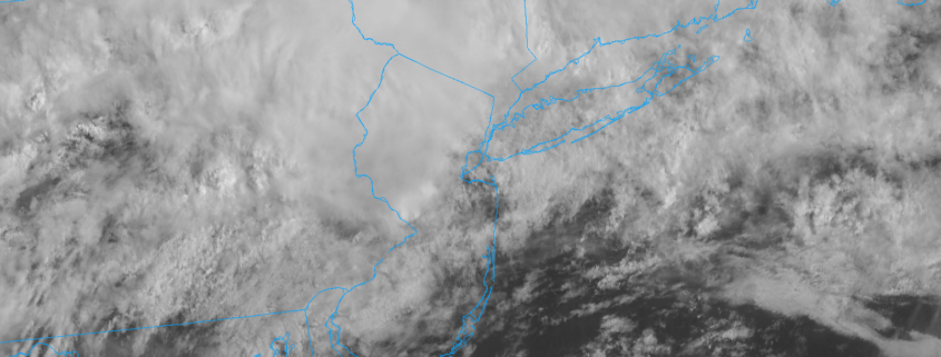
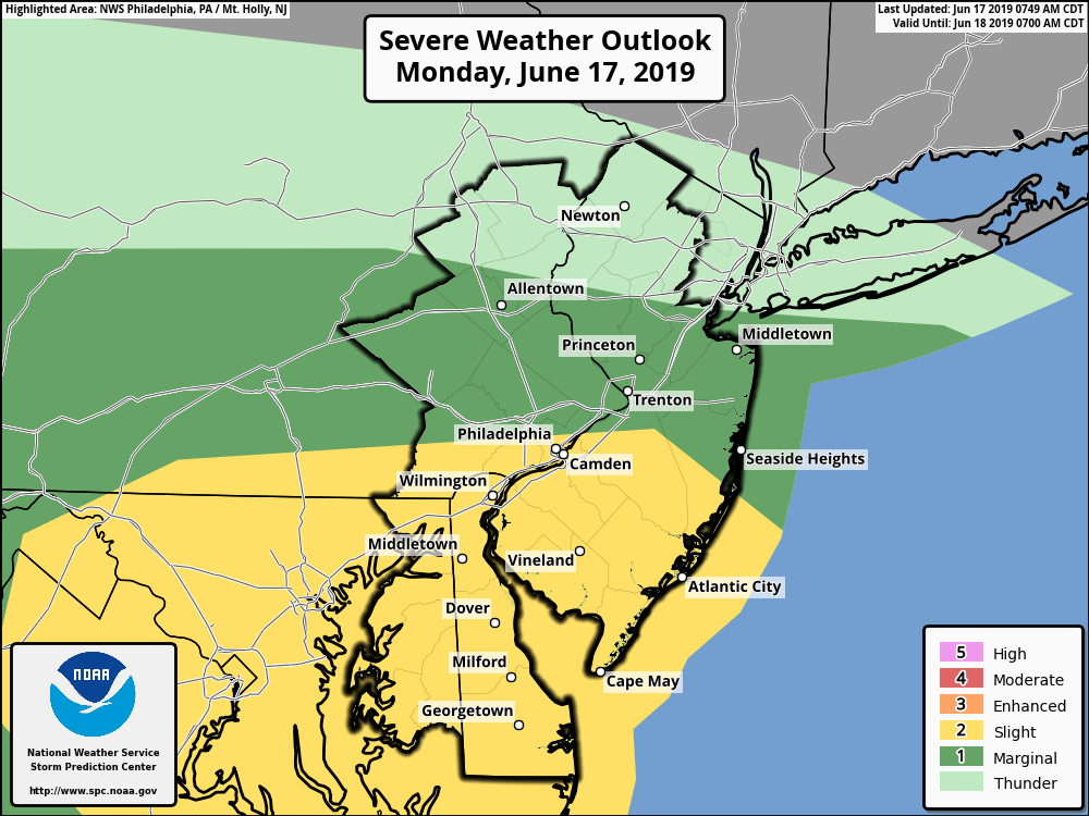
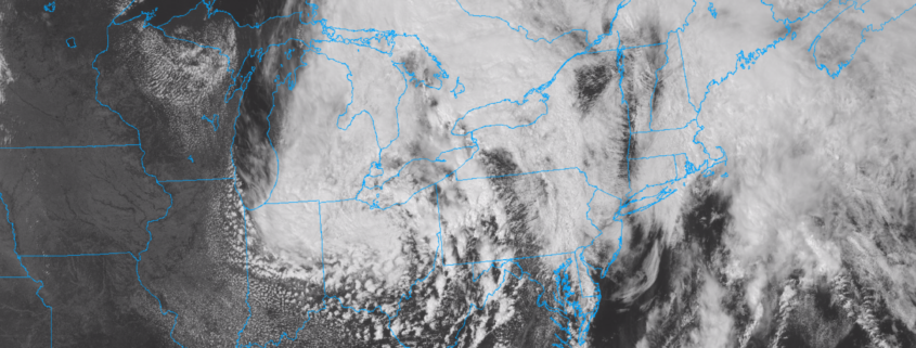
Multiple rounds of storms are possible today, particularly in Eastern Pennsylvania and New Jersey. The Storm Prediction Center has placed those regions in a Slight Risk for severe weather. Damaging wind gusts are expected to be the main threat with any storm, but hail and isolated tornadoes also cannot be ruled out. Heavy rain will also be a problem, with localized flooding expected. The threat for storms is being driven by the presence of a warm front, which is stalled near the area this morning. This front will serve as a focal point for storm development later today.
https://www.nymetroweather.com/wp-content/uploads/2019/06/newheader1.png7431523John Homenukhttps://www.nymetroweather.com/wp-content/uploads/2024/02/Empire-2000-x-300-px-2.pngJohn Homenuk2019-06-18 09:42:452019-06-18 09:42:45Strong and severe thunderstorms possible Tuesday
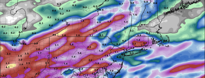
We’ve got some bad news for those of you searching for long, sunny summer days. An unsettled weather pattern looks likely to continue over the next week, characterized by frequent showers and thunderstorms. A warm front meandering near the area is the culprit in ensuring that the pattern remains less than ideal.
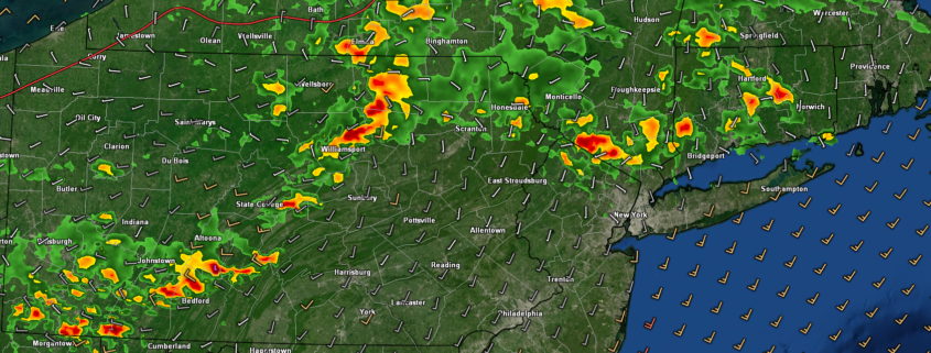
Opportunities for showers and storms will begin on Monday, with afternoon storms expected across Central and Southern New Jersey. While the worst of the storms will miss the NYC Metro Area to the south, showery and cloudy activity is still expected.
Meanwhile, further south, a threat for strong to severe thunderstorms is expected near a warm front. The Storm Prediction Center has, accordingly, placed parts of the Mid Atlantic in a Slight Risk for severe thunderstorms. The main threat with this activity on Monday afternoon will be strong wind gusts.
SPC has placed parts of Southern NJ in a Slight Risk for severe thunderstorms later today.
The pattern remains active
Even after storms pass through the area on Monday, additional rounds are likely on Tuesday and Wednesday. Tuesday, in particular, looks to feature mostly showery activity. Our area will be on the “wrong” side of the warm front. In other words, it won’t be warm, but there will be enough lift for precipitation.
Showers and storms are (surprise!) again possible on Wednesday afternoon and evening with another disturbance approaching the area. The main show, however, looks likely to come on Thursday when a more notable storm system approaches New England from the west/southwest.
It remains to be seen exactly how much instability will develop throughout the Mid Atlantic and Northeast. This will be a major factor in determining how impactful thunderstorms might be. The Storm Prediction Center has mentioned the region in their extended outlook:
Some severe risk should exist across parts of the southeast into the oh/tn valleys, mid atlantic, and perhaps the northeast on day 4/thursday as an anomalously amplified upper trough continues eastward over these regions. Instability is not currently forecast to be as strong thursday afternoon ahead of an eastward-moving cold front, owing mainly to a lack of steep mid-level lapse rates. However, strengthening mid-level flow suggests a potential for organized severe thunderstorms. A 15% severe area may eventually be introduced on day 4/thursday for some portion of these regions.
Storm Prediction Center
As we move closer to the end of the week, confidence will increase in regards to the factors that may contribute to the threat for strong and severe thunderstorms. Until then, we can proceed with the knowledge that unsettled weather will continue through the week.
The light at the end of the tunnel looks to become a bit brighter as we move toward the weekend, with some signs that high pressure will build in for a few days. This could result in a much needed stretch of dry and pleasant weather during the weekend ahead.
Here’s hoping.
https://www.nymetroweather.com/wp-content/uploads/2019/06/notdry.png5031097John Homenukhttps://www.nymetroweather.com/wp-content/uploads/2024/02/Empire-2000-x-300-px-2.pngJohn Homenuk2019-06-17 11:06:572019-06-17 14:00:36No good news: Unsettled weather to continue
Thankfully, conditions have improved quite dramatically today over the entire NYC metro area! Relatively calm conditions are likely through the first half of the weekend before conditions turn muggy & potentially stormy by Sunday!
https://www.nymetroweather.com/wp-content/uploads/2019/06/kisuebf.png9351685Steven Copertinohttps://www.nymetroweather.com/wp-content/uploads/2024/02/Empire-2000-x-300-px-2.pngSteven Copertino2019-06-14 18:52:012019-06-14 18:52:01Warm temps return, chance of storms through Monday
After a raw and rainy morning, the sun has made a cameo appearance this afternoon! It’s a welcomed sight, with temperatures spiking up into the upper 60’s (still well below normal for this time of year, by the way). Another round of showers and thunderstorms is possible with a secondary disturbance this afternoon and early evening. Thereafter, improving conditions are likely.
https://www.nymetroweather.com/wp-content/uploads/2019/06/Screen-Shot-2019-06-13-at-3.21.30-PM.png11822234John Homenukhttps://www.nymetroweather.com/wp-content/uploads/2024/02/Empire-2000-x-300-px-2.pngJohn Homenuk2019-06-13 15:28:122019-06-13 15:28:12PM Update: Clearing late tonight, warm and active pattern ahead
Hi friends! Our website uses cookies to provide an optimal browsing experience for you. New "Cookie Consent" laws mandate us to inform you of this. As long as you're cool with it, just hit OK. You'll only see this message once.
We may request cookies to be set on your device. We use cookies to let us know when you visit our websites, how you interact with us, to enrich your user experience, and to customize your relationship with our website.
Click on the different category headings to find out more. You can also change some of your preferences. Note that blocking some types of cookies may impact your experience on our websites and the services we are able to offer.
Essential Website Cookies
These cookies are strictly necessary to provide you with services available through our website and to use some of its features.
Because these cookies are strictly necessary to deliver the website, refusing them will have impact how our site functions. You always can block or delete cookies by changing your browser settings and force blocking all cookies on this website. But this will always prompt you to accept/refuse cookies when revisiting our site.
We fully respect if you want to refuse cookies but to avoid asking you again and again kindly allow us to store a cookie for that. You are free to opt out any time or opt in for other cookies to get a better experience. If you refuse cookies we will remove all set cookies in our domain.
We provide you with a list of stored cookies on your computer in our domain so you can check what we stored. Due to security reasons we are not able to show or modify cookies from other domains. You can check these in your browser security settings.
Other external services
We also use different external services like Google Webfonts, Google Maps, and external Video providers. Since these providers may collect personal data like your IP address we allow you to block them here. Please be aware that this might heavily reduce the functionality and appearance of our site. Changes will take effect once you reload the page.
-2")