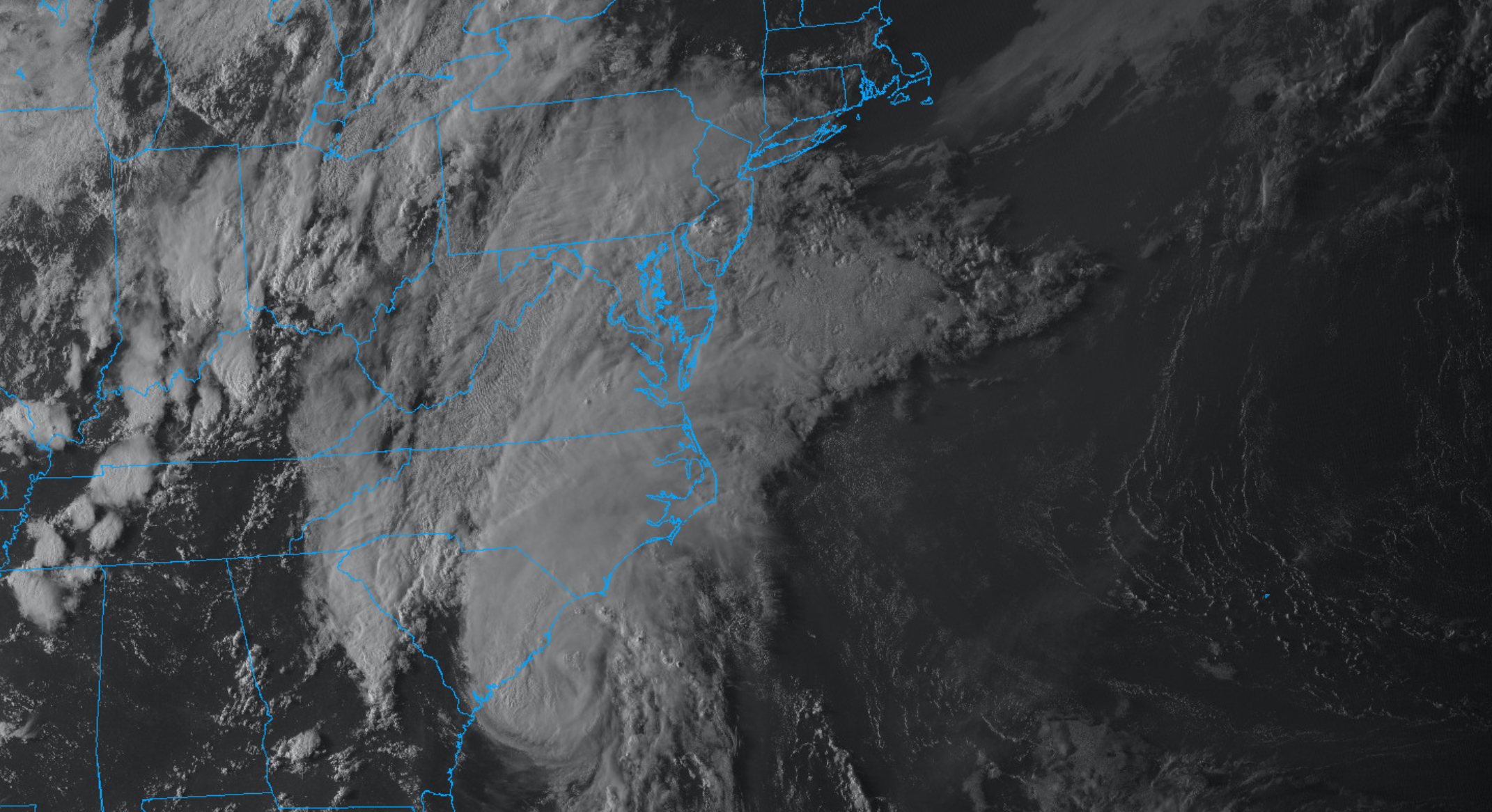
Tropical Storm Isaias is approaching the coast of the Carolinas this evening and is expected to make landfall as a hurricane tonight. Tropical moisture will surge northward through the Mid Atlantic his evening, setting the stage for a period of torrential rainfall and flooding across the NYC Area on Tuesday.
Several weather hazards are expected over the next few days in the NYC Metro Area. Warm and humid conditions will continue. Severe thunderstorms are possible on Sunday afternoon and evening. Heavy, tropical rainfall is possible on Monday. Additional heavy rainfall is expected as Tropical Storm Isaias moves towards the area by midweek.
QuickCast
This evening: Pleasant weather conditions are expected early on, with low temperatures in the 70’s. A few storms over the Mid-Atlantic will move towards the area later tonight, with a warm front moving toward the area by morning.
Sunday (8/2): Warm and humid conditions are likely with highs ranging from the upper 80’s to lower 90’s. Strong to severe thunderstorms are possible during the afternoon – with the threats of damaging winds, lightning and a few tornadoes. Conditions will improve later in the evening.
Monday (8/3): In and out sunshine early, followed by showers and thunderstorms increasing in coverage and intensity by afternoon. Expect torrential, tropical rainfall in these thunderstorms and the potential for localized flooding.
Severe storms possible on Sunday
A potent atmospheric disturbance is forecast to move into the Northeast states on Sunday, setting the stage for a very active afternoon and evening. During the morning hours, a warm front will lift northwards from the Mid-Atlantic states. This front will position itself north of New York City by the late morning hours, somewhere in the Hudson Valley region. South of the front, atmospheric instability will quickly increase.
With the presence of the mentioned disturbance will come seasonably strong wind shear (for early August standards) and wind profiles. The juxtaposition of this approaching disturbance, instability, and wind shear will lead to the potential for strong to severe thunderstorms during the afternoon and evening throughout the Northeast.
The main threat with developing thunderstorms will be dangerous lightning and strong, damaging winds. With that said, wind profiles suggest that the atmospheric regime will be supportive of supercell thunderstorms, which are infrequent in this part of the country. These rotating thunderstorms can and sometimes do produce tornadoes. The potential for tornadoes, while not high at any specific location, is slightly higher than your “typical” summertime thunderstorm event in the Northeast.
Tropical Storm Isaias impacts likely next week
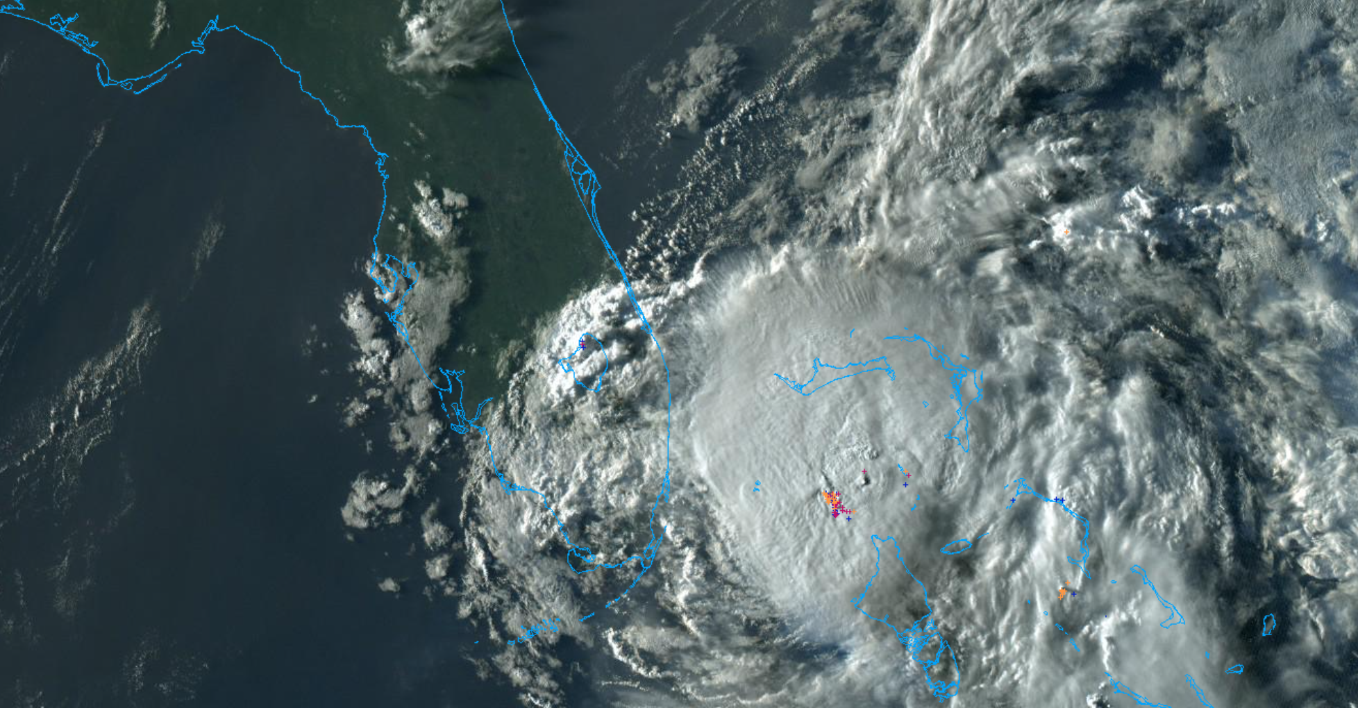
Tropical Storm Isaias is still meandering off the coast of Florida this evening, and has recently been downgraded from a Category 1 Hurricane. Still, the National Hurricane Center expects the storm to restrengthen, and is forecasting a hurricane to come close to the Florida coastline on Sunday.
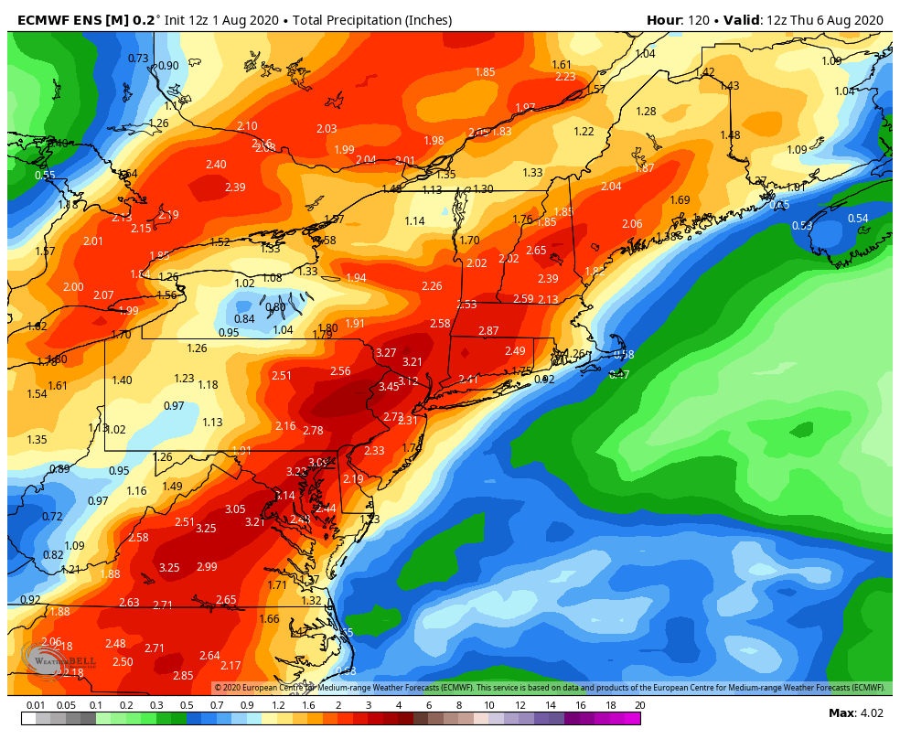
Isaias is expected to turn northwards up the East Coast early next week. Moisture from this system will be advected into the area while the storm is still several hundred miles away. This will lead to the potential for heavy, tropical rainfall as early as Monday afternoon and evening. The potential for flooding rains will continue through Monday Night.
On Tuesday, Isaias is forecast to track along the East Coast, and may pass very close to the area. As it approaches, we anticipate the potential for heavy rainfall and flooding – from Monday Night through Tuesday. Several inches of rainfall are possible in the area, and localized flooding could become a serious concern. If you live in a flood prone area, now is the time to have a plan in place and begin to explore options in the case that you need to evacuate or relocate.
Forecast models suggest that heavy, tropical rains may be accompanied by gusty winds – but the wind gusts are not expected to be the main story with this event. The expectation is that Isaias will be weakening as it moves up the coast, and heavy rainfall will be the headline in the NYC Metro Area.
We’ll have a detailed update on Sunday with timing, hazards, and preparedness information as Isaias begins to track towards the East Coast.
https://www.nymetroweather.com/wp-content/uploads/2020/08/Screen-Shot-2020-08-01-at-7.21.56-PM.png10201956John Homenukhttps://www.nymetroweather.com/wp-content/uploads/2024/02/Empire-2000-x-300-px-2.pngJohn Homenuk2020-08-01 19:24:282020-08-01 19:24:35NYC Forecast: Severe storms possible Sunday, Isaias impacts next week
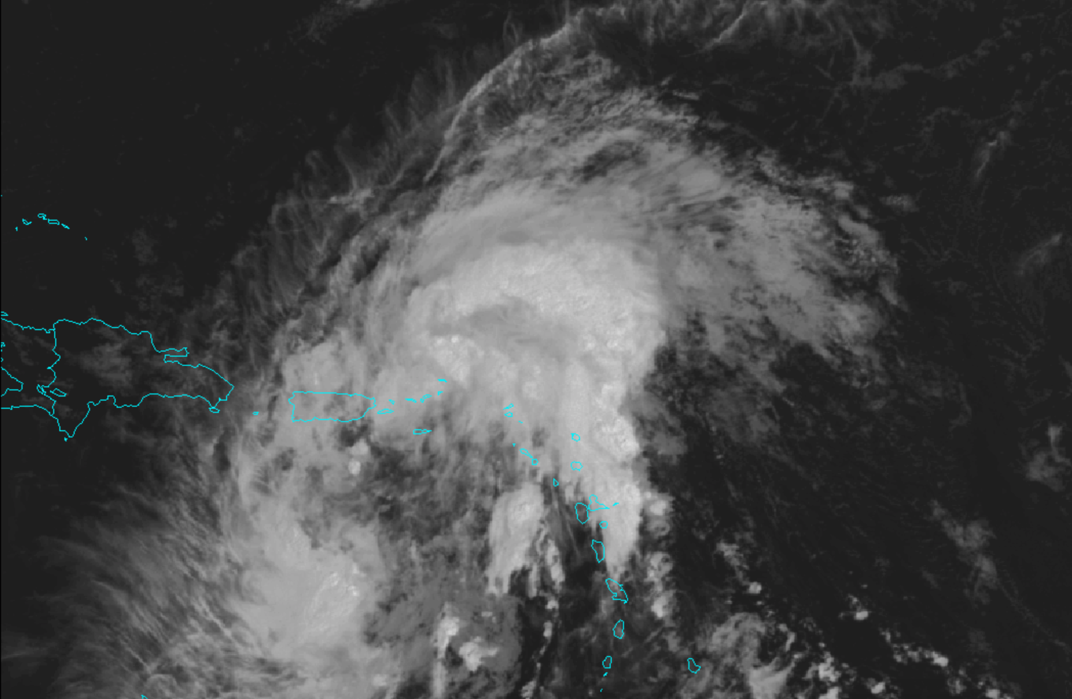
Potential Tropical Cyclone Nine (PTC9) has moved into the Caribbean today. The storm is expected to gradually strengthen into a Tropical Storm over the next 24-48 hours. Tropical moisture will also move up the East Coast next week, leading to the potential for heavy rainfall.
https://www.nymetroweather.com/wp-content/uploads/2020/07/Screen-Shot-2020-07-29-at-6.44.00-PM.png13682096John Homenukhttps://www.nymetroweather.com/wp-content/uploads/2024/02/Empire-2000-x-300-px-2.pngJohn Homenuk2020-07-29 18:47:392020-07-29 18:47:50PTC9 moves into Caribbean, tropical rains possible in NYC next week
Highlights: Heat will continue for the next few days, and a Heat Advisory remains in effect for the NYC Metro Area through Monday. Showers and storms are possible on Tuesday with a front passing the area. Seasonable conditions are then expected for the remainder of the week.
QuickCast
This afternoon: Hot and humid. Very light westerly winds, with an afternoon Seabreeze along the coast. Highs in the 90’s pretty much everywhere,
Tonight: Warm and humid weather continues, with lows in the 70’s. No weather hazards to speak of.
Monday (7/27): Partly cloudy with hot and humid weather continuing. This will be the hottest day of the week, with Heat Index values reaching near or over 100 F throughout a large part of the area.
Tuesday (7/28): A frontal boundary approaches the area, leading to the chance of showers and storms. Highs in the lower 90’s are still likely, with showers and storms during the afternoon. A few could be strong or severe.
Extended Forecast Discussion
Conditions will trend more seasonable as we move into the middle and latter portion of the upcoming week. High temperatures are likely to average from the mid 80’s to lower 90’s throughout the area, with very little chance of precipitation. In fact, conditions look mostly dry from Wednesday into the weekend. Humidity will also trend a bit lower during this time.
As we move towards next weekend, temperatures should begin to warm above seasonal averages again, and humidity will increase as ridging builds back in towards the area. Expect highs to begin creeping back into the lower 90’s during this time, with dew points returning to slightly more uncomfortable levels.
Eyes will more than likely turn to the tropics during this time as well, with disturbance 92L forecast by almost all ensemble guidance to gradually move towards the United States. Uncertainty is extremely high in regards to the systems eventual development and track, but the synoptic weather pattern across the Atlantic Ocean and North America suggests that we should keep an eye on it. We’ll have a separate article on 92L later today.
Hi friends! Our website uses cookies to provide an optimal browsing experience for you. New "Cookie Consent" laws mandate us to inform you of this. As long as you're cool with it, just hit OK. You'll only see this message once.
We may request cookies to be set on your device. We use cookies to let us know when you visit our websites, how you interact with us, to enrich your user experience, and to customize your relationship with our website.
Click on the different category headings to find out more. You can also change some of your preferences. Note that blocking some types of cookies may impact your experience on our websites and the services we are able to offer.
Essential Website Cookies
These cookies are strictly necessary to provide you with services available through our website and to use some of its features.
Because these cookies are strictly necessary to deliver the website, refusing them will have impact how our site functions. You always can block or delete cookies by changing your browser settings and force blocking all cookies on this website. But this will always prompt you to accept/refuse cookies when revisiting our site.
We fully respect if you want to refuse cookies but to avoid asking you again and again kindly allow us to store a cookie for that. You are free to opt out any time or opt in for other cookies to get a better experience. If you refuse cookies we will remove all set cookies in our domain.
We provide you with a list of stored cookies on your computer in our domain so you can check what we stored. Due to security reasons we are not able to show or modify cookies from other domains. You can check these in your browser security settings.
Other external services
We also use different external services like Google Webfonts, Google Maps, and external Video providers. Since these providers may collect personal data like your IP address we allow you to block them here. Please be aware that this might heavily reduce the functionality and appearance of our site. Changes will take effect once you reload the page.
-2")