NYC Forecast: Storms today, pleasant fourth, warmth ahead

Highlights: Showers and thunderstorms, some strong and severe, are expected this afternoon. A pleasant and somewhat cooler day is likely for the Fourth of July. Heat and humidity will return to the forecast by next week, when a heat wave looks increasingly likely.

QuickCast 

Hazards: A few showers and thunderstorms expected this afternoon. 

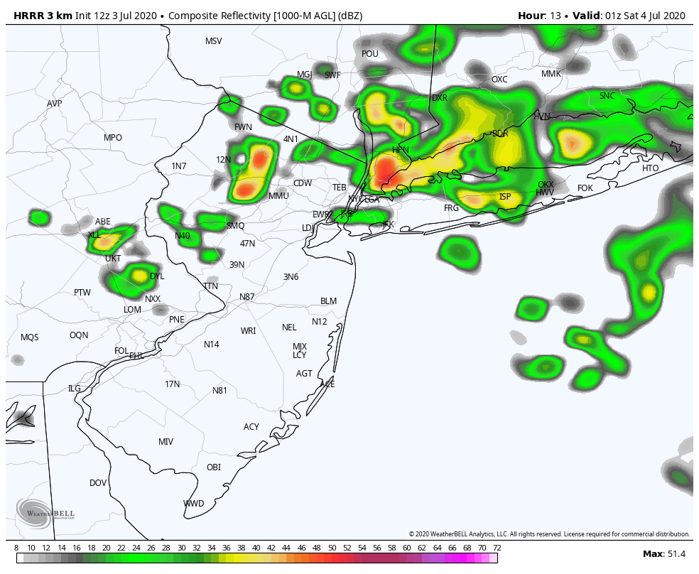
This afternoon: Warm temperatures are likely, with highs in the lower 90’s. The air will feel increasingly humid as the day goes on and showers and thunderstorms will develop by the afternoon. These will move in to the area from the north (different, we know!), and may pose a threat for strong wind gusts and hail, along with dangerous lightning.

  • Hazards: Storms, a few strong, could contain heavy rain, gusty winds and hail
  • Timing: 2pm – 8pm

Tonight: Showers and storms could persist into the early evening, but will gradually taper off. Lows in the mid 60’s to near 70 in the city.

Independence Day (7/4): Partly cloudy and noticeably cooler. Less humid, too, with highs in the mid 80’s.

HRRR model showing showers and storms in the NYC Metro Area later this afternoon.

Detailed Forecast Discussion

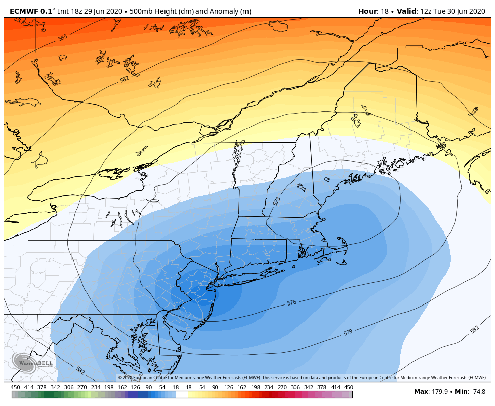
The weather will remain unsettled for one more day, as an upper level low makes its grand exit from the region. This is the same upper level low that has spun around in our area for the entire week, providing several days of showers and thunderstorms. Expect temperatures to become much warmer as we head into the afternoon with humidity rising as well. Atmospheric instability will build, and showers and storms will develop after 1pm, across portions of New England at first. Gradually, these will build southward towards the NYC Area.

Strong, gusty winds and some small hail are possible. While weak wind shear will limit the threat for severe weather overall, the potential will exist for severe storms at times. Local enhancement of these storms could occur along any sea breeze boundaries – like we saw a few days ago.

Independence Day (7/4): The main story on the Fourth of July will be less humidity, as the upper level low will begin shifting away from the area. This will very likely be the coolest day for at least a week. High temperatures will only reach the middle 80’s with a nice, dry breeze.

Sunday (7/5): The airmass near the area will quickly become more humid and warm once again as ridging and high pressure build in. South/southwesterly winds will begin to usher in warmer air and temperatures will rise closer to 90 degrees during the afternoon.

Euro ensemble showing high and low temperatures above average in the NYC Area for the foreseeable future.

Extended Forecast

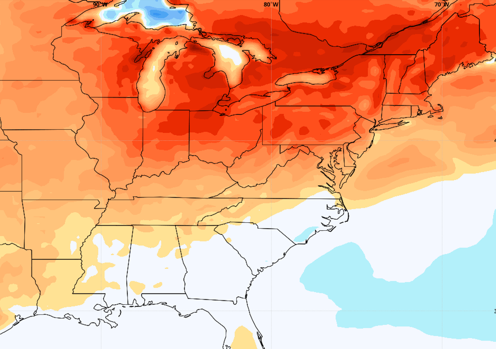
Forecast models are in excellent agreement that for the first time this summer, ridging and high pressure will build into the Northeast without any resistance. This will allow heat and humidity to surge towards the region unabated by next week. The result will be several days of warm, southwest winds. Accordingly, model data agrees that a heat wave is possible during the middle of next week. In fact, there could be several days in a row with high temperatures over 90 degrees in the NYC Metro Area. This heat and humidity looks likely to persist at least towards next weekend, at which point the longevity of it becomes unclear.

NYC Forecast: Active weather continues through midweek

Highlights: Active and unsettled weather will continue this week, with chances for showers and thunderstorms each afternoon. Temperatures warm into the upper 80’s and lower 90’s by later in the week, with warmth continuing into the weekend. 

QuickCast 

Hazards: A few showers and thunderstorms expected this afternoon.

This afternoon: Seasonably warm, with highs in the 80s’. North winds between 5 and 10 miles per hour. Isolated to scattered showers and storms likely after 2pm, continuing into the early evening.

  • Hazards: Storms, a few strong, could contain heavy rain, gusty winds and hail
  • Timing: 2pm – 8pm

Tonight: Showers and storms tapering off. Lows in the middle 60’s with a light east breeze. 

Wednesday: Partly cloudy with a few showers and storms expected during the afternoon and evening once again. Highs a bit warmer, in the mid 80’s.

Detailed Forecast Discussion

An upper level low is spinning over the Northeast states this week, and will lead to a chance of showers and thunderstorms each afternoon and evening. Instability and wind shear in the atmosphere will be somewhat marginal, but a few strong/severe storms are possible. High temperatures are likely to be closer to 80 degrees today, but will climb gradually warmer as we move towards the weekend. By Independence Day, expect highs in the upper 80’s to near 90, with rising humidity and plenty of sunshine.

An upper level low is situated over the area this week, providing unsettled weather with chances for storms each afternoon.

Wednesday (7/1): Partly cloudy conditions are expected to start the day, but showers and some thunderstorms will likely return by the afternoon hours. Once again, a few strong to severe storms will be possible locally. Sea breeze fronts could locally enhance the potential for strong winds or hail. Otherwise, expect temperatures in the 80’s with light east/northeast winds.

Thursday (7/2): The disturbance over the area begins to slide away, with warmer and calm weather settling in. Temperatures will trend warmer, into the upper 80’s, but conditions are expected to remain mostly dry.

Extended Forecast

Later this week, high pressure will remain in control of the areas weather. This is likely to lead to a period of dry, warm weather through the weekend. There are some indications on the latest forecast model guidance that ridging could expand from the Central US towards the area next week. This could lead to a prolonged period of much warmer temperatures, with highs in the 90’s for several days in a row. Confidence is quite low in exactly how the pattern evolves, but is rising overall for a period of warmth and humidity extending through mid-July.

NYC Forecast: Active weekend ahead, another cutoff low en route

Highlights: Humidity will rise again later today, and temperatures will warm up again by Friday. Active weather is likely this weekend, with the chance for showers and thunderstorms, especially on Saturday. Active weather will persist into next week.

QuickCast

Hazards: Slight Risk of severe thunderstorms on Saturday afternoon.

This afternoon: Warm and comfortable with temperatures in the mid 80’s. Dew points increase as we move later into the evening, a light breeze persists.

Tonight: Partly cloudy and a bit warmer than last night. Lows in the upper 60’s to near 70.

Friday: Warmer and more humid once again. Highs in the upper 80’s with a light breeze.

Detailed Forecast Discussion

Changeable weather is back in the forecast, and after a brief respite from the humidity we anticipate rising dew points once again later this evening. Temperatures will remain relatively comfortable, but the airmass will begin to feel heavy once again. Conditions turn more active this weekend, with a frontal boundary approaching the area on Saturday and leading to the potential for strong thunderstorms. Next week, the weather looks to remain active.

Friday (6/26): Mostly pleasant conditions are expected, although temperatures and dew points will be higher than they were on Thursday. Expect highs in the middle to upper 80’s, with the chance for some isolated afternoon thunderstorms, mainly across the interior. Mostly clear conditions are likely during the evening, but temperatures will be noticeably warmer than they were over the past few days. Low temperatures in and around the city may not drop below 70 degrees.

Saturday (6/27): An active weather day is likely, with a front approaching from the north. Showers are possible during the early morning hours with a warm front nearby. Thereafter, anticipate some clearing and warming temperatures once again. Redevelopment of showers and storms is likely during the afternoon hours. Some of these storms could be strong to severe, mainly west of the NYC Metro. The Storm Prediction Center has placed parts of the area in a Level 2 (Slight) risk of severe thunderstorms as a result.

Storms are currently most likely to occur across parts of Pennsylvania and New Jersey during the early to middle afternoon hours. These may shift into parts of the NYC Metro during the late afternoon or early evening. As mentioned, the best chance for severe weather is in the interior, but heavy rainfall is still possible from storms impacting the city proper.

Extended Forecast

There has been minimal change to the ongoing forecast expectation. An upper level low is expected to drift southward from Canada next week. While the details of timing and intensity are uncertain, the position of the upper low should encourage a northeast flow, which would suggest cooler temperatures and a chance of showers through the middle of the week – with heat and humidity temporarily deflected away from the area again.

NYC Forecast: Unsettled weather likely to persist

Highlights: A temporary decrease in humidity occurs later today, but will be followed by the return of unsettled weather this weekend. Another upper level low may deflect heat from the region next week, and lead to an increasing chance of showers.

Read more