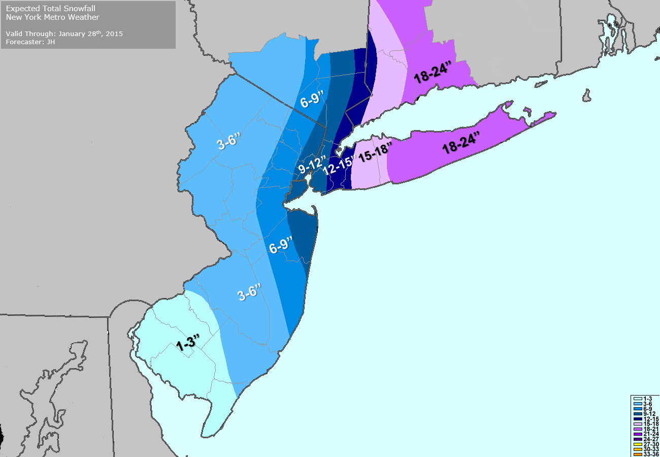
No spring for you! Mother nature has other ideas today — and it seems she hasn’t realized that Winter is over. A mid level disturbance moving from the Ohio Valley to the Northeast States will force the development of a surface low pressure system off the Mid Atlantic Coast. Light snow will spread from southwest to northeast today, becoming moderate and steady during the afternoon. Periods of heavy snow are anticipated this afternoon and evening. When all is said and done, most areas will see between 1 and 3 inches of snow — but a band of 3 to 5 inches of snow is likely from Eastern PA through Central NJ toward New York City.
Follow along with our Live Blog today as our meteorologists update with the latest information, data, observations and forecast:
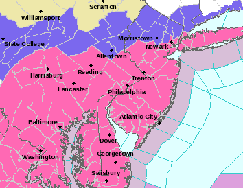
4:00pm: The National Weather Service has issued Winter Storm Warnings for most of New Jersey including the New York City Metro Area from late tonight into Thursday. Generally, their forecast calls for 3 to 6 inches of snow with higher amounts of 5 to 9 inches possible south of New York City throughout parts of Central New Jersey. Lighter amounts of 2 to 5 inches are expected farther north in New Jersey, where a Winter Weather Advisory is in effect. You can read the warning text here.
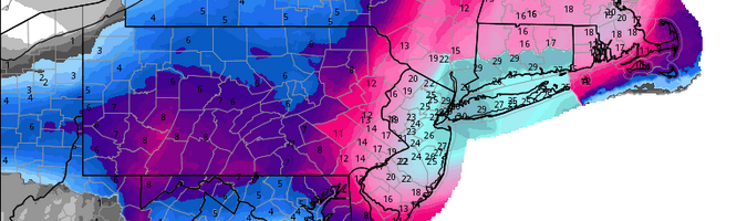
2:35pm: We are now beginning to get into range of the HRRR Model (High-Resolution Rapid Refresh). It updates every hour and only runs out to 15 hours in time. It can sometimes be good at pinpointing short-term trends in banding and changeovers from rain to snow. The latest HRRR model has rain changing to sleet at around midnight, then to snow at around 2:00am, and it comes down very heavily.
HRRR Model showing the changeover from rain to snow overnight (Courtesy of Weatherbell Analytics).
These may be subject to further updates since a lot of the reports are old (we are awaiting the final numbers from NYC and LaGuardia Airport). But generally speaking, NYC through Brooklyn and Queens had 10-13″, Nassau County had 12-18″, Suffolk County had 18-30″, but areas west of NYC generally received much less snowfall. The gradient was quite sharp, as most people from Nassau County and east got close to or as much snow as was expected, but the heavy snowfall banding did not make it that far west. We explain the forecast bust here.
Overnight 1/27: We actually lost internet, so updates were tough to come by. The heavy banding from the ocean produced consistent whiteout conditions in Suffolk County, occasional whiteout conditions in Queens and Nassau, but not very much west of that as the air remained very dry just to the west of the band. In an area of heavy banding, there is very strong lift, but the atmosphere has a balancing act, so that often just to the west of areas with strong lift — especially with a storm that passes well to the east — there is an enhanced area of subsidence, that prevents the band from crossing further west.
Here is a video of the near-whiteout conditions in Rockville Centre, NY:
9:00pm 1/26: West of NYC was always supposed to be an area where snowfall totals could theoretically rapidly drop, and the latest NAM model hints at this. Heavy snow on the new run literally hits a wall in NYC, and doesn’t make it much further west than that. Whether it’s right or not we don’t know, and the latest observations still do show a westward push to the radar. But the idea of a strong cut-off west of NYC could be a realistic idea.
Areas east of NYC still look to do very well in the snowfall department.
7:10pm 1/26: Technical Update: For those who are worried about the HRRR not showing much snow for the region, we have a couple of things to say:
1) The latest HRRR is a bit west of its previous run.
2) More importantly, meteorologist Phillippe Papin made the astute observation that the HRRR can suffer problems with retrograding coastal systems. When precipitation is over the ocean, the HRRR can only see what the radar sees, since currently radar reflectivity is implemented into it. The radar in itself has a limited understanding of latent heat release with deepening ocean cyclones that does not occur with cyclones over land (the ocean has a lot more moisture than the land for latent heat release!) This could cause the HRRR to see the storm as being weaker, and thus make it more prone to jump the cyclone towards convection and push the storm further east.
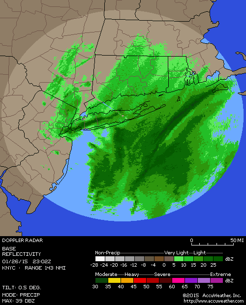
6:45pm 1/26: The push westward has begun! The ocean banding has already pushed into most of Long Island, and should be in NYC by 8:00pm, and continue to push westward from there. Snowfall will gradually get heavier as it approaches, but the heaviest snow will be after midnight.
5:00pm 1/26: Governor Cuomo has announced that the entire NYC Subway system will be shut down at 11:00pm tonight.
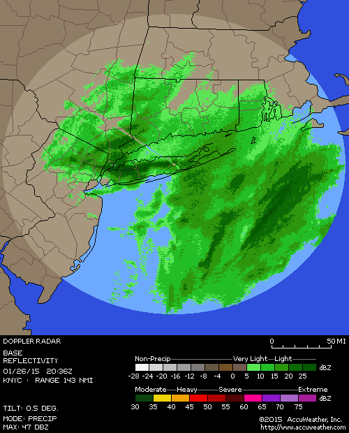
4:15pm: A very heavy snow band has set up near NYC, in Queens and Long Island. LaGuardia airport has reported 2″ in the last hour! New Jersey remains to the west of this band so their snowfall totals are much lighter.
There are hints that the precipitation in the ocean is merging with the band and trying to back NW towards the coast, though that hasn’t happened decisively yet. What we need to watch is the progression of this precip — the models that give us heavier snow have a clear westward leaning towards that precip by 7:00pm. We would like to see that occur if the snowier models are going to verify. As of now, areas east of NYC look great for 15″+ of snow, but there are still uncertainties from NYC and west.
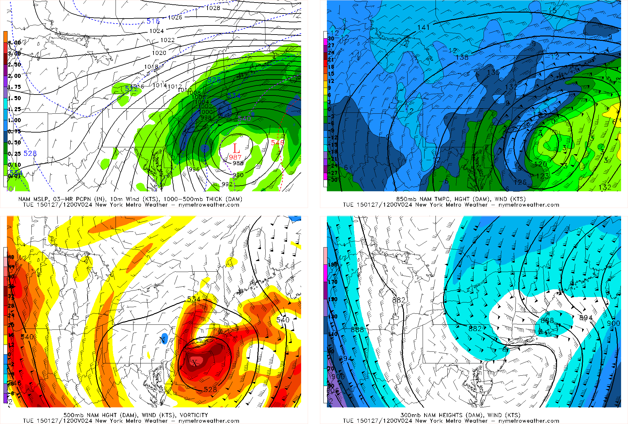
3:05pm: Latest NAM model confirms the observations of the trough being more negatively tilted than forecast. It takes the storm and tucks it in west off the NJ coastline and stalls! Amounts would be exceed 2 feet in many locations if this run were to verify. Note: This is NOT our forecast, but it could indicate that the heavier snow amounts may extend further west, like previous European Model guidance.
2:40pm: Snow has already greatly picked up in intensity, and is coming down moderately to heavily at times. Many locations have already reported 2-3″ of snow in our area, with nearly 1″ per hour snowfall rates. We think this is because the negatively tilted trough has allowed for some isentropic lift to be oriented from SE to NW, and then some convergence once that fetch hits the land adds to the lift, allowing snow to form. It also allows snow to reform at the shores instead of moving away, because the convergence keeps feeding more snow bands. These snowfall rates are expected to continue for at least the next hour or two, creating a very messy evening commute. Roads are already quite treacherous.
9:30am: Well, the European Model is king. The NAM model just came in and showed a 100% textbook scenario of how to get historic snowfall in the NYC area. It closes the 500mb low to our south and stalls the surface low, while the 700mb low and lifting is absolutely ideal for heavy banding.
Today’s NAM model valid for early tomorrow morning is textbook for snow, as the 500mb low and 850mb low are closed off in perfect spots for heavy snow, and heavy banding just sits and spins over our area.
As far as current weather conditions, the initial burst of snow has overperformed somewhat. And while there may be a brief lull in the action this morning, bands of moderate snow are forming in S NJ and heading our way.
8:35am: We’re back in action this morning! Not much has changed overnight. Light snow continues to fall throughout much of the region. This is occurring due to a weak disturbance aloft, riding out ahead of the main show later this afternoon. There is enough moisture in the atmosphere to produce light snow. This is modeled to continue throughout the day today, with banding slowly working northwest from the Western Atlantic Ocean through New Jersey and eventually toward NYC tonight. Roads will become progressively worse after around noon today. So if you have to travel tonight, we recommend making plans to do so earlier. Our forecast has not changed and our Storm Total Snowfall map remains the same as it was yesterday. Our forecasters are working on any potential tweaks and attempting to refine the map as best as possible.
The NWS Watches and Warnings included below also remain unchanged. Hang tight for updates today!
1:15am 1/26: What a rollercoaster of model runs. Other guidance had backed off a bit as well, but was still very close to the bigger amounts. This led to the big question: would the Euro model hold? And that it did. It still gives the NYC area 2 feet of snow and locally higher in some spots. That is not our forecast, but it does seem to question the models that backed off. The key was that the European model did not shove the surface low towards the area of convection, and instead it got captured and turned NW, like old runs. It actually deepened even more than the previous run, though it did tick slightly east — which really only reduces snowfall for W NJ and E PA.
Below, you will find our live blog which will be active and public throughout the day on Wednesday. Our meteorologists will update frequently with information on the storm, including the latest updates and information. Comment with any observations, information and thoughts you have as well!
Hi friends! Our website uses cookies to provide an optimal browsing experience for you. New "Cookie Consent" laws mandate us to inform you of this. As long as you're cool with it, just hit OK. You'll only see this message once.
We may request cookies to be set on your device. We use cookies to let us know when you visit our websites, how you interact with us, to enrich your user experience, and to customize your relationship with our website.
Click on the different category headings to find out more. You can also change some of your preferences. Note that blocking some types of cookies may impact your experience on our websites and the services we are able to offer.
Essential Website Cookies
These cookies are strictly necessary to provide you with services available through our website and to use some of its features.
Because these cookies are strictly necessary to deliver the website, refusing them will have impact how our site functions. You always can block or delete cookies by changing your browser settings and force blocking all cookies on this website. But this will always prompt you to accept/refuse cookies when revisiting our site.
We fully respect if you want to refuse cookies but to avoid asking you again and again kindly allow us to store a cookie for that. You are free to opt out any time or opt in for other cookies to get a better experience. If you refuse cookies we will remove all set cookies in our domain.
We provide you with a list of stored cookies on your computer in our domain so you can check what we stored. Due to security reasons we are not able to show or modify cookies from other domains. You can check these in your browser security settings.
Other external services
We also use different external services like Google Webfonts, Google Maps, and external Video providers. Since these providers may collect personal data like your IP address we allow you to block them here. Please be aware that this might heavily reduce the functionality and appearance of our site. Changes will take effect once you reload the page.
-2")

