Active and Wet Pattern to Return Middle of Next Week and Beyond

Good afternoon, everyone! We hope you are enjoying this lovely Friday. For more information on the general day-to-day weather including the slight chance of strong thunderstorms on Easter evening, please refer to the main dashboard or the AM Zones Article. This article is going to be focused on the pattern moving forward.

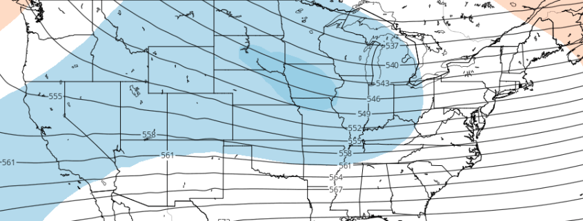
After a winter with really not much in the way of high-latitude blocking, that has changed in March and to some extent this month. While it has not been a 100% constant, it has been persistent, and after a brief break, will return next week and help shunt an active Pacific Jet a bit further south. This initially further south position of the Pacific Jet will allow storms to traverse the country a bit further south than usual for this time of year, which should be southward enough to give us synoptic forcing for heavy rain.

Read more

3.25 AM LR/AG: Wet, active pattern still likely to develop

Good morning! While Saturday mornings are a bit more quiet for our AG/Long Range friends — we didn’t forget about you! Hopefully you’re able to grab a cup of coffee and enjoy a quick discussion with us. Our article this morning will be a bit shorter, as we briefly detail some updates and the latest information we’re analyzing on the pattern ahead. The pattern change we have been discussing for a few weeks is already underway.

Yesterday we spoke at length about the upcoming pattern and why we believe it will feature more active, stormy tendencies across the Plains and the Central United States including the Southern and Central Corn Belt. Not much has changed with our current thinking moving forward over the next week or two. As we move into the upcoming weekend, multiple storm threats will have already evolved across the Central United States.

Read more

3.23 LR/AG: Active pattern with multiple severe weather chances

A happy Thursday evening to you all! We hope you’ve had a wonderful day and are sitting down to read and chat with us regarding the upcoming long range weather pattern. We’ve got a lot to cover and will do our best to lay it out in an understandable and explanatory format. For a few weeks now, our forecasters have been discussing a change to the atmospheric pattern across the Northern Hemisphere during the end of March. These changes are still likely to occur and will lead to a much different weather pattern than the one we’ve been observing over the past few weeks.

From early March up until today, the pattern over the Northern Hemisphere has been essentially altered by the presence of high latitude blocking. This is better defined as the presence of ridging, or “blocking” high pressures in the atmosphere across parts of Canada, Greenland, and the Arctic. These are critically important because they alter the atmospheric flow in those regions and dislodge cold air, usually bottled up north, further south into the USA. The presence of this blocking has resulted in a colder pattern, particularly across the Northeast, in March.

Things are about to change.

Read more

Long Range: Warmth on the way, but for how long?

A happy Friday morning to you all! A large-scale pattern change is underway throughout much of the hemisphere — well, to be completely transparent, has been underway throughout much of the hemisphere — for the past few days. The seeds of the pattern change were planted long ago, almost 10 days before today, when a large ridge in the Eastern Pacific Ocean began to retrograde westwards towards the Aleutian Islands.

But even as recently as early this week, a ridge stood along the US West Coast, allowing northern stream energy (emanating from Canada and the arctic/polar regions) to drop southwards into the Northeast States. This ridge will finally collapse this week, dropping eastwards and flattening out. As it does so, arctic air over the Northeast states will be fleeting northeastwards into the Canadian Maritimes.

Read more