Alt

Heat, storms increasingly likely the next two weeks

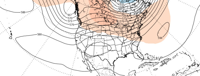
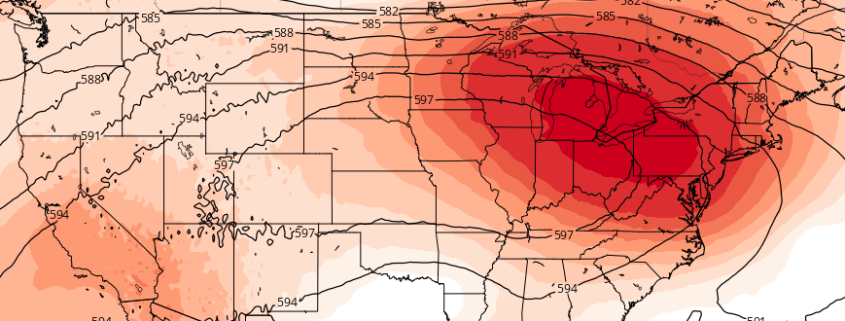
A large and anomalous heat ridge is forecast by most mid-range operational and ensemble model guidance to build over the Central United States. The process will actually begin by early next week, as heights in the mid and upper levels of the atmosphere rapidly increase over the Central United States. Troughing over the Northwest United States will act to enhance this ridging, with mid and upper level heights approaching anomalous levels by the middle to end of next week.

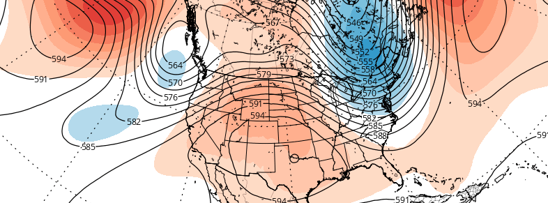
Medium range ensemble support, at this range, is actually quite remarkable. Both the GFS and ECMWF ensemble means (the averages of multiple-member ensemble runs) show a tremendous ridge over the Central US, pulsing and expanding northeastward toward the Great Lakes and Northeast. While the brunt of the unbearable heat will likely miss our area to the south and west, the heat will still be felt. More notably, however, is the fact that our area will likely lie along the periphery of this ridge, in the path of multiple atmospheric disturbances.

Read more

Atmospheric pattern may support periods of heat by mid July

Warmer temperatures have returned this week, with highs reaching back into the middle and upper 80s. But the pattern still has yet to change to support any type of heat waves — and it doesn’t look like it will over the next week or so. Another cooling trend during the latter half of next week will bring an end to the month of June. For those who are looking ahead to the warm, hot days of summer, or trying get a heads up on any excessive heat for crops — this may escalate the amount of questions in regards to how this summer will turn out. Are there any changes expected to the atmospheric pattern over the next few weeks?

A ridge amplifying over the West Coast early this week will lead to a large trough over much of the Central and Eastern US for the later half of this week and into the July 4th holiday weekend. This pattern evolution can be largely attributed current +PDO influence and MJO progression during neutral ENSO conditions thus far this meteorological summer. This pattern should continue for another couple of weeks, before any significant changes take place to support more heat over Northeast US..

Ahead of this large trough this week will be a slow-moving cold front that could cause some showers and thunderstorms with possibly some heavy rainfall from late tonight through Wednesday. After this cold front moves passed the region, high pressure builds in briefly for Thursday with temperatures near average in lower or 80s. Then more embedded disturbances moving around this trough could provide more chances for showers and thunderstorms on Friday and then possibly over the July 4th holiday weekend.

Read more

Premium: Cooler than average trend to persist through June

While many long range forecasts have been banging the “heat drum” for several weeks now, that heat has yet to materialize in any fashion throughout the Northeast United States during the first few weeks of meteorological summer. The next few weeks, additionally, are unlikely to offer any chances for prolonged heat or above average temperature departures.

In fact, there are growing signals, from both the hemispheric pattern evolution and climate phenomena, that below normal temperatures and unsettled conditions may return to the area to close out the month of June.

Read more

Premium: Tropical forcing likely to support warmer late May pattern

Cooler temperatures are on their way tomorrow and early next week with a large anomalous upper-level low moving over the Northeast. Some waves along a stalled frontal boundary may also affect the weather during the middle of next week. But we are still anticipating warmer temperatures in late May.  We have already discussed a number of reasons why we believe more warmth is on the way. But a major influence in this pattern shift will likely be tropical forcing from an active MJO event occurring over the Indian Ocean now.

First, the ensembles guidance still show the AO/NAO turning positive with more troughiness over Greenland/Davis Strait. This will not support as much troughiness, nor an upper-level low over the Northeast or Southeast Canada. Also a -PNA pattern will be developing with troughiness digging over the Southwest US. This will causes heights to build over much of the Central and Eastern United States.

Read more