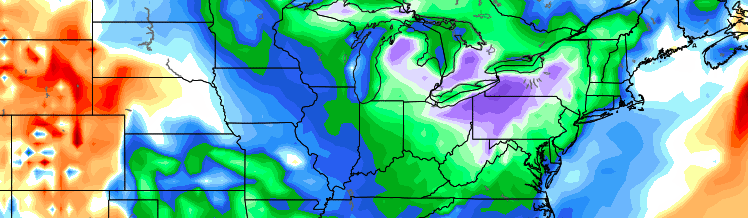
It’s almost too fitting. For much of the winter, meteorologists and hobbyists alike spend countless hours attempting to forecast and predict the likelihood of high latitude blocking development. This year, stratospheric warming events were expected to kick off changes that would eventually lead to the development of said high latitude blocking, and change our pattern to a cold and snowy one. While the pattern turned cold and snowy for sure, the high latitude blocking never came to fruition. In fact, the NAO stayed positive for much of the winters duration.
https://www.nymetroweather.com/wp-content/uploads/2015/04/Screen-Shot-2015-04-23-at-9.59.49-AM.png218748John Homenukhttps://www.nymetroweather.com/wp-content/uploads/2024/02/Empire-2000-x-300-px-2.pngJohn Homenuk2015-04-23 10:01:242015-04-23 10:01:24High latitude blocking puts Spring on hold
This is not the news many were hoping to hear this morning. Unfortunately, it’s the news we have to provide as a result of medium and long term forecast modeling and the overall hemispheric evolution over the next two weeks. Luckily for those who enjoy the warmth, today looks to be the winner of the week. Behind a mid level atmospheric disturbance which provided the area with rain on Tuesday, warm mid level temperatures will remain in the area on Wednesday. Periods of sunshine and west winds will allow temperatures to rise into the mid to upper 50’s throughout the area. Some areas will approach and may even exceed 60 degrees during the afternoon. Others, especially near the shore, will remain slightly cooler.
The warmth, as is often the case this time of year, won’t last long. Colder mid and upper level temperatures will push southward on Thursday and Friday and temperatures will move back toward more normal levels. The transient pattern will continue through the weekend as another disturbance approaches — bringing precipitation mainly in the form of rain, as temperatures briefly warm up once again before crashing back down on Sunday. Still, that will be just the beginning of the trend toward a colder, more active pattern which will establish itself in the medium to long range.
For any readers who want to know more about any potential rain tonight, as well as the weather for Friday and the weekend, check out our latest forecast discussion. There may even be some scattered showers and isolated thunder with a cold pool aloft, as mid-level lapse rates will be near 7C/KM tomorrow afternoon.
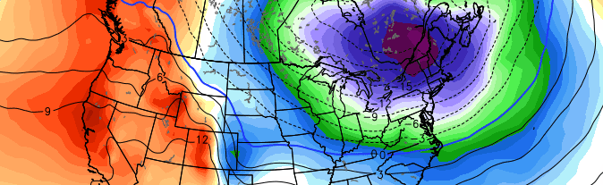
While our area sits in low level moisture and clouds, former Super Typhoon Nuri has transitioned into an extratropical storm, but is forecast to fall to pressures below 920mb! This would be one of the strongest extratropical cyclones on record.
This extremely strong cyclone will help to release plenty of latent heat and energy towards the Poles, which will generate an anomalously strong ridge in Alaska and western Canada. In short, as the extratropical system becomes a behemoth both at the surface and aloft, the strong jet stream and digging trough in the mid and upper levels create an anomalous ridge to their east, pumping a ridge from the West Coast into British Columbia. This ridge will be so strong that it will also flow into the Arctic, tanking the Arctic Oscillation. This allows the Polar Vortex to be weakened and sent to the south on the downstream side of the ridge.
Accordingly, forecast models are in good agreement that the Polar Vortex will split into two, with a piece sagging southward toward Southern Canada during the middle to latter part of next week.
https://www.nymetroweather.com/wp-content/uploads/2014/11/eu.png481716Doug Simonianhttps://www.nymetroweather.com/wp-content/uploads/2024/02/Empire-2000-x-300-px-2.pngDoug Simonian2014-11-06 20:44:102014-11-06 21:06:33Wintry pattern change coming by late next week
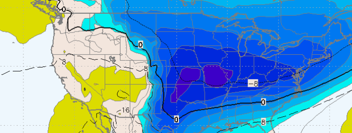
As we’ve spoken about several times already this Autumn, our winter forecast doesn’t typically come out until the first week of November. Although some will bark at us for this — we’ve been hearing it already this Autumn — there are reasons for it. Mainly, our forecasters have recognized the importance of analyzing the pattern during October and the ideas moving into November. The recognition of the pattern during the next few weeks will be immensely important to understanding how things will shake down this winter. And our first “hint” could be offered during the next several days, as the AO — or Arctic Oscillation — is forecast to take a nose-dive.
The Arctic Oscillation is a large scale monitor of climate variability, also referred to as the Northern Hemisphere Annual mode. More simply, it’s a climate pattern characterized by winds circulating counterclockwise around the Arctic — typically at around 55°N latitude. In even more simple terms — the negative phase of the AO typically displaces cold air farther south in North America, while the positive phase keeps the colder air farther north, nearer to the poles and arctic regions. Forecast models are in good agreement that the AO will nosedive over the next several days — and not surprisingly, a major shot of below-normal temperatures is expected late this weekend into early next week.
https://www.nymetroweather.com/wp-content/uploads/2014/10/downtown-nyc-snow-1-26-2010-2.jpg11951600John Homenukhttps://www.nymetroweather.com/wp-content/uploads/2024/02/Empire-2000-x-300-px-2.pngJohn Homenuk2014-10-02 11:48:542014-10-02 11:50:30Plummeting AO could offer some winter hints
Hi friends! Our website uses cookies to provide an optimal browsing experience for you. New "Cookie Consent" laws mandate us to inform you of this. As long as you're cool with it, just hit OK. You'll only see this message once.
We may request cookies to be set on your device. We use cookies to let us know when you visit our websites, how you interact with us, to enrich your user experience, and to customize your relationship with our website.
Click on the different category headings to find out more. You can also change some of your preferences. Note that blocking some types of cookies may impact your experience on our websites and the services we are able to offer.
Essential Website Cookies
These cookies are strictly necessary to provide you with services available through our website and to use some of its features.
Because these cookies are strictly necessary to deliver the website, refusing them will have impact how our site functions. You always can block or delete cookies by changing your browser settings and force blocking all cookies on this website. But this will always prompt you to accept/refuse cookies when revisiting our site.
We fully respect if you want to refuse cookies but to avoid asking you again and again kindly allow us to store a cookie for that. You are free to opt out any time or opt in for other cookies to get a better experience. If you refuse cookies we will remove all set cookies in our domain.
We provide you with a list of stored cookies on your computer in our domain so you can check what we stored. Due to security reasons we are not able to show or modify cookies from other domains. You can check these in your browser security settings.
Other external services
We also use different external services like Google Webfonts, Google Maps, and external Video providers. Since these providers may collect personal data like your IP address we allow you to block them here. Please be aware that this might heavily reduce the functionality and appearance of our site. Changes will take effect once you reload the page.
-2")