As we have alluded to in previous articles, the weather pattern across the globe is currently undergoing changes. A lot of this has to do with recurving Typhoon Wipha, as the large storm generated a trigger to produce a large ridge ahead of it. This helps to create a more amplified pattern, slowing things down. A slower global pattern is what tends to lead to more blocking, and the blocking that we are seeing this month could be a very important player as we head towards winter.
The reason it’s important is because there is a significant correlation — especially recently — between a -NAO in October and a -NAO during the following winter. One reason among many for this is because a -NAO pattern will often establish itself in October, relax a bit during November, and then re-establish itself during the winter. Our previous article highlights the detailed research and correlations, which will help you contextualize what is being written in this article.
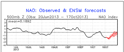
The prudent question to ask now would be how the NAO has been doing so far, and if it will stay negative for the rest of the month.
The NAO has been negative this month, and should continue to remain negative for the rest of the month. The black line represents the observed values, and the red lines represent the forecast values from the GFS ensembles.
https://www.nymetroweather.com/wp-content/uploads/2024/02/Empire-2000-x-300-px-2.png00Doug Simonianhttps://www.nymetroweather.com/wp-content/uploads/2024/02/Empire-2000-x-300-px-2.pngDoug Simonian2013-10-17 15:00:152013-10-17 18:09:24Update: October NAO and what it means for winter
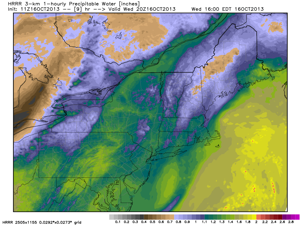
The combination of a weak coastal system, meandering off the Mid Atlantic coast, and multiple mid level disturbances moving through the Northeast US will result in generally unpleasant weather from Wednesday through the end of the week. The coastal system is weak but brings moisture and an onshore flow, as the decaying mid level vorticity slowly retrogrades towards the coast on Wednesday. Low clouds and drizzle are possible, despite the lack of any steady rain, especially near the coasts.
Mid level disturbances shifting northeast from the Mississippi and Ohio Valleys through the Great Lakes and Northeast will bring more unsettled weather through the end of the week — signaling the beginnings of a more active pattern. The weekend is expected to feature improving conditions once the frontal system eventually moves off the coast.
High resolution models showing increasing Precipitable Water values by later Wednesday evening.
https://www.nymetroweather.com/wp-content/uploads/2024/02/Empire-2000-x-300-px-2.png00John Homenukhttps://www.nymetroweather.com/wp-content/uploads/2024/02/Empire-2000-x-300-px-2.pngJohn Homenuk2013-10-16 07:47:312013-10-16 09:11:03Cloudy, drizzly and unsettled through weeks end
Global climate change has been a pretty hot topic in the world of meteorology and climatology for quite some time now. Skeptics and pro AGW (Anthropogenic — meaning human as opposed to natural — Global Warming) have raged on and on. One of the main components that people like to look at to track the degree of warming is the amount of Arctic Sea Ice loss. As the calendar slides through August and into September, we get closer and closer to the minimum ice extent for the year, before recovering for the fall and winter. Arctic Sea Ice has really declined in the past several years — potentially due to AGW, as the amount of loss last year was absolutely staggering. In fact, the entire 2007-2012 period saw unprecedentedly low levels of Arctic Sea Ice that led many to become quite worried about this being the new normal.
Most global climate simulations indicate that the area of greatest warming would be in the Arctic — mainly because it is easier to heat something that is cold than what is hot. Decreasing the amount of Arctic Sea Ice could lead to lots of devastating climate feedbacks on the Earth’s system, such as a lot less radiation being deflected back into space, and further yielding warming. This is because ice and snow have a higher albedo (ability to reflect heat radiation back into space) than water. Thus, a warming arctic –> more water and less ice & snow –> lower albedo in the arctic –> less heat radiation is reflected back into space (and is instead absorbed by the water) –> warming arctic. This means that the feedback helps to amplify the original effect of warming the arctic, without increasing the warming effect itself.
When the Artic regions are quite warm, this is obviously bad for many ecosystems alike. But it would also greatly alter the weather patterns in that it would change the jet stream configuration, since if you are warming the Arctic a lot more than the equatorial latitudes, you are decreasing the temperature gradient between the two, which is what fuels the jet stream to begin with. There are a lot more climate feedbacks and such, but to save time, we won’t get into that for now.
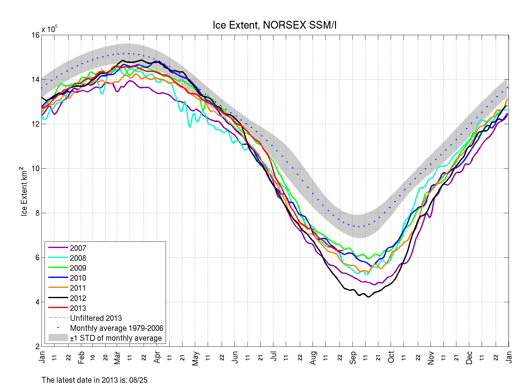
Figure 1: Arctic Sea Ice extent from this year (red) is much higher than from last year (black). However, it is still well below the 1979-2006 averages.
Arctic Sea Ice can be measured in two ways: ice extent and ice area. The National Snow and Ice Data Center explains the differences well here, but essentially, the analogy is swiss cheese. Extent would be the distance from the edges of the cheese and all of the space inside the edges — so it does not include the holes, whereas the area takes the holes into account. There are pros and cons to using each method, but the NSIDC uses extent.
The chart above shows the Arctic Sea Ice extent from the past several years, in comparison with the 1979-2006 averages. Obviously, we are still well below the 1979-2006 averages, so it is not time to “cancel” global warming. However, we have had a very significant recovery from this time last year — it is almost two million square kilometers above last year’s level! This is great news. Although we are really only near the 2009 level and not necessarily that deviant from the past several years, the increase is quite significant and a bit unprecedented, since year-to-year increases of this magnitude are rare.
https://www.nymetroweather.com/wp-content/uploads/2024/02/Empire-2000-x-300-px-2.png00Doug Simonianhttps://www.nymetroweather.com/wp-content/uploads/2024/02/Empire-2000-x-300-px-2.pngDoug Simonian2013-08-27 13:32:012013-08-28 00:43:24Arctic Sea Ice Loss Not Nearly as Bad as Last Year
We finally saw a nice break today from the high humidity values, as dewpoints dropped into the low 60s this afternoon, making it feel quite comfortable outside this afternoon. With the lower humidity, this means that temperatures have more room to drop tonight — mid 50s in colder, inland areas to mid 60s in more coastal sections. This is quite the stark contrast from the constant stream of 70s for lows that we have had all month.
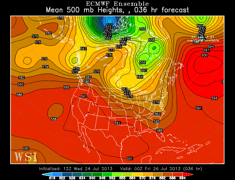
European Ensemble Mean Valid for tomorrow evening shows a frontal boundary being stalled as it runs into the stubborn Western Atlantic Ridge. Image courtesy of the WSI Model Lab.
As far as what is going on with the synoptic weather pattern, the heat wave has broken as that huge ridge has finally dissipated and split into two ridges — one in the southwest, and one in the NW Atlantic. The NW Atlantic ridge is the same one that has been plaguing us all summer with humidity, showers, thunderstorms — and at times, heat. Although it has fluctuated in position at times, it has generally remained in the western Atlantic.
This 500mb image valid for tomorrow evening gives a good general summary as to what is going on now and what we can expect over the next few days. There is a trough in the northeast, as a cold front made its way through the area yesterday, giving us drier conditions. However, there are still clouds around as the front has stalled just to our east. Because of the tremendously strong western Atlantic ridge of 600 decameters (!), the front was forced to stall, as it ran into a “wall”, instead of clearing the coast. This leads to a tight 500mb height gradient along the eastern seaboard (which in this case is pretty much a frontal boundary). This leads to the potential for waves of low pressure to develop along this front.
Since the front is just to our east, the biggest rainfall threat would be east of NYC, with NYC itself being on the gradient. For now, we will mention the relatively high chance of showers, with periods of moderate rain at times — especially in eastern sections of the region (such as Long Island) — in an otherwise relatively mostly cloudy regime for tomorrow. With surface winds more northerly, instability should be too low for much in the way of thunderstorm activity, as temperatures may not get out of the 70s tomorrow. A stark change from last week, considering our lows were often in the mid to upper 70s!
https://www.nymetroweather.com/wp-content/uploads/2024/02/Empire-2000-x-300-px-2.png00Doug Simonianhttps://www.nymetroweather.com/wp-content/uploads/2024/02/Empire-2000-x-300-px-2.pngDoug Simonian2013-07-24 19:15:302013-07-24 19:24:45Big heat on hold for the foreseeable future
Hi friends! Our website uses cookies to provide an optimal browsing experience for you. New "Cookie Consent" laws mandate us to inform you of this. As long as you're cool with it, just hit OK. You'll only see this message once.
We may request cookies to be set on your device. We use cookies to let us know when you visit our websites, how you interact with us, to enrich your user experience, and to customize your relationship with our website.
Click on the different category headings to find out more. You can also change some of your preferences. Note that blocking some types of cookies may impact your experience on our websites and the services we are able to offer.
Essential Website Cookies
These cookies are strictly necessary to provide you with services available through our website and to use some of its features.
Because these cookies are strictly necessary to deliver the website, refusing them will have impact how our site functions. You always can block or delete cookies by changing your browser settings and force blocking all cookies on this website. But this will always prompt you to accept/refuse cookies when revisiting our site.
We fully respect if you want to refuse cookies but to avoid asking you again and again kindly allow us to store a cookie for that. You are free to opt out any time or opt in for other cookies to get a better experience. If you refuse cookies we will remove all set cookies in our domain.
We provide you with a list of stored cookies on your computer in our domain so you can check what we stored. Due to security reasons we are not able to show or modify cookies from other domains. You can check these in your browser security settings.
Other external services
We also use different external services like Google Webfonts, Google Maps, and external Video providers. Since these providers may collect personal data like your IP address we allow you to block them here. Please be aware that this might heavily reduce the functionality and appearance of our site. Changes will take effect once you reload the page.
-2")