Snow has begun tapering off and ending southwest to northeast across all zones early this morning. This occurs as low pressure tracks east-northeast off the North Carolina coast and more lift with an associated upper-level jet streak start to move the northeast of the region. Most snowfall reports so far have been between 1” – 3″, as expected. Some additional light accumulation is possible over the next few hours over Eastern parts of Long Island and Connecticut that could bring snowfall totals to near 4”. Otherwise, take more precaution driving out roadways, as some slick spots will likely remain for another into the mid-morning hours.
https://www.nymetroweather.com/wp-content/uploads/2017/01/gfs_z500_vort_us_7.png6961024Miguel Pierrehttps://www.nymetroweather.com/wp-content/uploads/2024/02/Empire-2000-x-300-px-2.pngMiguel Pierre2017-01-06 06:18:472017-01-06 07:39:23Light snow tapers off this morning…more light snow possible Saturday
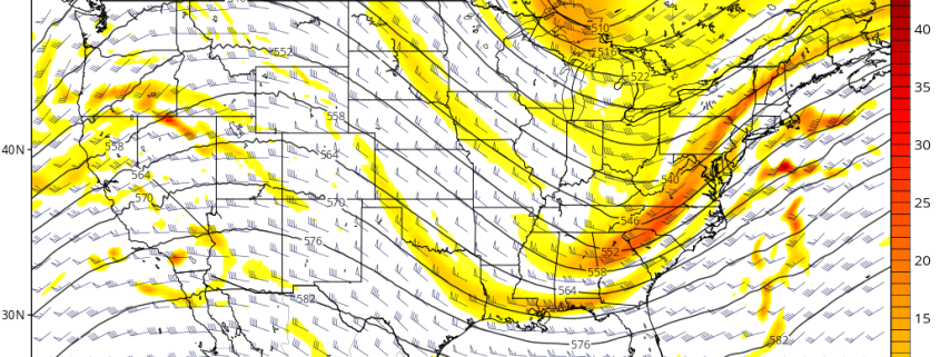
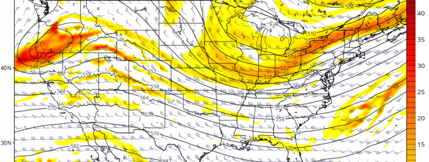
As many of you know by now, there are two threats for snow over the next few days: the first of which starting late Thursday night and Friday, and the second of which on Saturday. While most model guidance verbatim is still not impressive with either threat, there have been many impressive trends today, particularly with the second storm, as that one has a much higher ceiling. The UKMET model, for example, shows a big snowstorm for a 2nd straight run, the ECMWF and its ensembles made another large jog westward.
The first disturbance is via a Polar shortwave that dives southward into the Northern Plains from Canada. This shortwave is pretty potent and resembles a lot of past setups that have a late-blooming low pressure that drop a few inches of fluffy, high-ratio snow. What’s preventing this event from having a truly high ceiling is that this shortwave is not truly detached from the downstream flow and initial vortex in SE Canada, so it cannot become its own entity. This shunts the positive vorticity advection main access offshore where there is a separate area of disjointed vorticity rather than the area where the main shortwave is. The main shortwave instead simply serves to buckle the flow a bit and provide more dynamics rather than directly correlate with the track of the system. That being said, this shortwave may still trend amplified enough to allow a last second north jump with a weak low pressure offshore that can give a few inches of snow to coastal areas.
https://www.nymetroweather.com/wp-content/uploads/2017/01/ecmwf_z500_mslp_us_5.png6961024Doug Simonianhttps://www.nymetroweather.com/wp-content/uploads/2024/02/Empire-2000-x-300-px-2.pngDoug Simonian2017-01-03 19:03:032018-05-01 12:57:59Inching Closer to Snow this Weekend
Overview: A weak disturbance will bring some light precipitation to parts of the region during today. A larger storm system will impact the region with more rainfall and milder temperatures tonight and Tuesday. A cold front moving through by Wednesday will deliver much colder air later next week.
Today (Monday): Mostly cloudy with a 30% chance light rain showers.Highs in the middle 40s.
Tonight: Mostly cloudy. 40% chance of rain showers. Lows around 40 then temperatures rising late.
Tuesday, Mostly cloudy and much milder. Periods of rain likely. Highs in middle 50s.
Wednesday: Partly sunny and still very mild with highs in the middle 50s.
Thursday: Mostly sunny and colder. Highs in the middle 30s.
Friday: Mostly cloudy with a 30% chance of light snow. Highs in the lower 30s.
Saturday: Mostly cloudy and very cold. A 30% chance of light snow. Highs in the upper 20s.
Sunday: Mostly cloudy with a 30% chance of light snow. Highs in the lower 30s.
https://www.nymetroweather.com/wp-content/uploads/2017/01/gfs.gif6961024Miguel Pierrehttps://www.nymetroweather.com/wp-content/uploads/2024/02/Empire-2000-x-300-px-2.pngMiguel Pierre2017-01-02 17:42:392017-01-02 17:42:39Zone 1 NYC Metro Test Blog
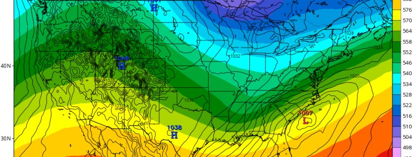
A period long discussed as a potential “window” for wintry weather is now within the short to medium range, and forecast models continue to hone in on the development of wintry weather for parts of the Eastern Untied States, particularly the Northeast US as early as Friday and Saturday. A large ridge in the Pacific Ocean will dislodge cold air into Canada and the Northern 1/3 of the US, while an active jet stream pattern continues.
The first disturbance approaches the area during the middle part of this week, with an additional disturbance from the polar jet driving southwards through Central Canada and potentially phasing with a trough over the Ohio Valley. This phase could allow a storm system to form quickly off the Mid Atlantic coast, with precipitation spreading northwards into the Northeast US.
Hi friends! Our website uses cookies to provide an optimal browsing experience for you. New "Cookie Consent" laws mandate us to inform you of this. As long as you're cool with it, just hit OK. You'll only see this message once.
We may request cookies to be set on your device. We use cookies to let us know when you visit our websites, how you interact with us, to enrich your user experience, and to customize your relationship with our website.
Click on the different category headings to find out more. You can also change some of your preferences. Note that blocking some types of cookies may impact your experience on our websites and the services we are able to offer.
Essential Website Cookies
These cookies are strictly necessary to provide you with services available through our website and to use some of its features.
Because these cookies are strictly necessary to deliver the website, refusing them will have impact how our site functions. You always can block or delete cookies by changing your browser settings and force blocking all cookies on this website. But this will always prompt you to accept/refuse cookies when revisiting our site.
We fully respect if you want to refuse cookies but to avoid asking you again and again kindly allow us to store a cookie for that. You are free to opt out any time or opt in for other cookies to get a better experience. If you refuse cookies we will remove all set cookies in our domain.
We provide you with a list of stored cookies on your computer in our domain so you can check what we stored. Due to security reasons we are not able to show or modify cookies from other domains. You can check these in your browser security settings.
Other external services
We also use different external services like Google Webfonts, Google Maps, and external Video providers. Since these providers may collect personal data like your IP address we allow you to block them here. Please be aware that this might heavily reduce the functionality and appearance of our site. Changes will take effect once you reload the page.
-2")