Premium Weekly Outlook 5/23 – 5/29: 80+ Degree Temperatures by Wednesday…More T-Storm Chances?

Some unsettled weather will start off this week with a cut-off low tracking in the region. But much warmer and drier conditions will finally arrive with temperatures soaring well into the 80s away from the shore by Wednesday and Thursday. The main question remains: will this warming trend to continue into the Memorial Day weekend, or is more cooler/ unsettled weather with showers and thunderstorms in store? We discuss more technical details and thoughts with the upcoming weather this weekly period.

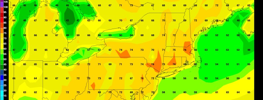
So far — Monday began with plenty of sunshine as weak high pressure temporarily built into the region.  Despite a northeast flow, deep mixing will help temperatures today to rise in the middle to upper 70s.  This brings our temperatures to slightly above average for late May. Closer to the south-facing shores,  temperatures will be cooler with sea-breezes developing and pushing inland later this afternoon.

Read more

Premium: Intricate phase will determine magnitude of coastal storm

The details of a phase between a mid level disturbance over the Ohio Valley, one with surprising vigor, and a second disturbance dropping southward from Southeast Canada into the Northeast, will have significant impacts on the eventual evolution of a coastal storm system this weekend. The atmospheric evolution in the mid and upper levels is actually quite complex, and reminiscent of some of the storm systems that impact our area in the winter season.

The pattern actually begins becoming amplified and energetic today (Friday), as a large trough in the Western United States amplifies. This will force a large ridge axis to build to its east, over the Central Plains states. This ridge drives northward, amplifying into Central Canada. This sets the stage for a large and amplifying trough over the Eastern United States this weekend.

Read more

Premium Weekly Outlook 5/16 – 5/22: Moderation to around average temperatures late week

After some cooler temperatures today and then some more unsettled weather for Tuesday and Wednesday, moderating temperatures to near normal with pleasant weather returns late this week. But there is a potential fly in the ointment for a warming trend to continue this weekend as a coastal storm may try to develop. For this weekly outlook, we’ll discuss some technical details and thoughts on the weather through this week and this coming weekend.

After a very chilly start with temperatures near record lows across the region, temperatures today should be a little warmer than Sunday’s high temperatures with slightly warmer mid-level temperatures, deep mixing and more sunshine in the afternoon. High temperatures should rise into the lower to middle 60s for much of the region today. A tight pressure gradient and winds around 40kts on top of a deep mixed layer will also cause west-northwest winds to gust between 30mph and 40mph again today. The west-northwest winds will also keep sea-breezes from developing this afternoon for coastal locations.

Read more

Premium: Tropical forcing likely to support warmer late May pattern

Cooler temperatures are on their way tomorrow and early next week with a large anomalous upper-level low moving over the Northeast. Some waves along a stalled frontal boundary may also affect the weather during the middle of next week. But we are still anticipating warmer temperatures in late May.  We have already discussed a number of reasons why we believe more warmth is on the way. But a major influence in this pattern shift will likely be tropical forcing from an active MJO event occurring over the Indian Ocean now.

First, the ensembles guidance still show the AO/NAO turning positive with more troughiness over Greenland/Davis Strait. This will not support as much troughiness, nor an upper-level low over the Northeast or Southeast Canada. Also a -PNA pattern will be developing with troughiness digging over the Southwest US. This will causes heights to build over much of the Central and Eastern United States.

Read more