(Premium) Intensity of weekend cold still uncertain

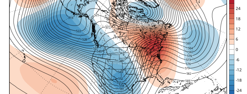
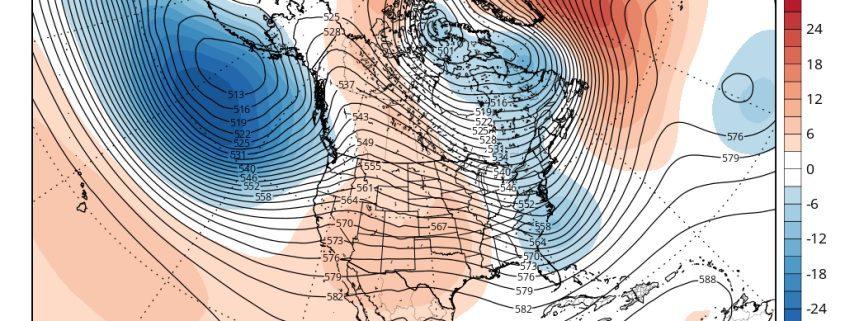
After many of us geared up for Spring with warm weather in both the early and middle part of March, the atmosphere reminded us that no transition is as smooth as it may seem. Colder, blustery air has returned to the area, and although a mild stretch is expected during the middle of this coming week, very cold air will again surge into the area by this weekend. As we spoke about several days ago, forecast models have done an excellent job of signaling the overall pattern teleconnections and evolution, with a surge of cold air possible during the first week of April.

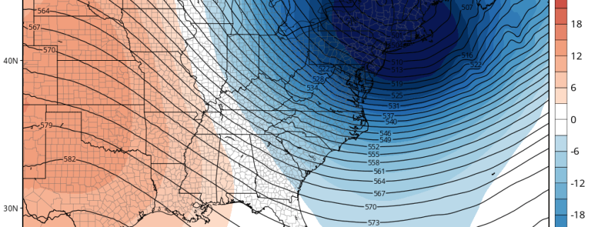
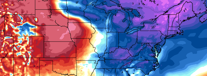
Over the past few days, however, the intensity and duration of this cold air has come into question. Forecast models have trended slightly weaker overall with the lobe of the Polar Vortex which will break off and head southward into Southeast Canada and Northern New England. Accordingly, the forecast temperatures in our area have moderated a bit. While the overall evoltion of the pattern still suggests anomalously cold air gets to our region, a more south-to-north gradient appears likely, with the coldest temperatures likely north of New York City and more slight to moderate departures from normal to the south.

Read more

(Premium) Long Range: Is the End of Winter in Sight?

In the world of meteorology, Spring begins on March 1st. While the calendar doesn’t turn until the end of the month, meteorologists end winter statistics on the last day of February. Some winters, however, have featured major cold or snowstorms well into March and even April. Remember last year? Still, a year makes a big difference, as they say, and there are growing signs that after this week, cold and snow will become increasingly unlikely.

Looking back at February, temperatures will likely average above normal throughout the area. While we saw the first below zero temperatures in New York City in over two decades on Valentines Day, much of this month featured near or above average temperatures. Artic cold airmasses didn’t hang around for more than a few days. A couple of winter storms we saw earlier in the month tracked too far east to give the entire region of significant snowfall. And in the past two weeks, we have seen a storm track farther west with warmer air and heavy rainfall, as cold air moves in behind the storms.

Read more

(Premium) Will There Be An East Coast Snowstorm March 4th-5th?

After the midweek storm which is likely to be all rain, we are watching for the potential for storm system to develop near the Southeast US in the March 3-5 period.

Strong high pressure with much colder air will follow behind the midweek storm. Meanwhile, a shortwave will dig downstream off the West Coast ridge over the Rockies. This shortwave will become part of the southern stream and cause a low pressure storm system to develop over the Central or Southern Plains. Models indicate this storm will track towards Southeast or Lower Mid-Atlantic coast by Friday.

Read more

(Premium) Record Breaking Cold Possible Sunday Morning… Another Storm Next Week?

A piece or lobe of the Polar Vortex will swing south over the Great Lakes and Northeast. This supports an Arctic front passing through Friday night. Some snow showers or snow squalls are possible again tomorrow night with this front. Behind this front will be a potentially historic cold airmass for parts of Northeast. Saturday will see temperatures fall from the lower 20s to teens and single digits during the afternoon hours. Winds will also be increasing, as wind gusts between 30mph to 40mph are possible during the day. Thus, windchills will drop to near or below zero and may approach dangerous levels by Saturday evening.

Read more