Friday AM Briefing: Changeable weather in the East, wintry threat next week?

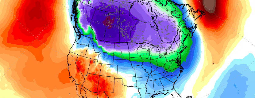
Good morning, and Happy Friday! Finally. Cold and dry weather built back into the Northeast states on Thursday, and temperatures dropped near or below normal in many locations thanks to a transitional trough moving through Southeastern Canada. Such has been the nature of this pattern over the past week or two – relatively fast moving, without any slow or cutoff storm systems. As we look ahead to the weekend, things are likely to warm up across the Northeast States.

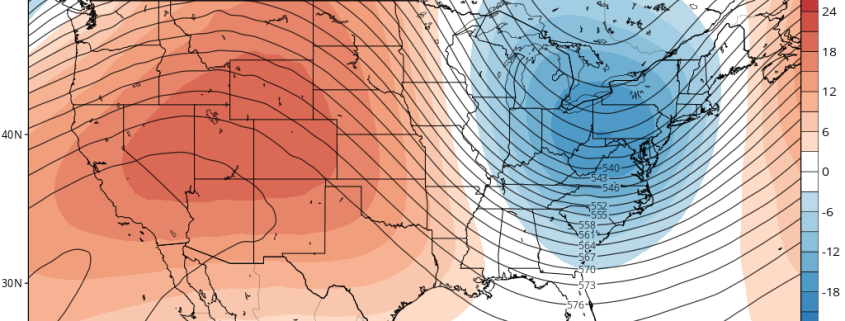
A ridge rolling eastward from the Central Plains, which is bringing above normal temperatures to a large majority of the Central United States today, will move towards the Eastern United States this weekend. While surface temperatures won’t exactly be torching, temperatures will rise well above seasonal averages over a large area. A frontal system will then bring the opportunity for rain on Sunday across the Tennessee Valley, Mid Atlantic and Northeast.

Read more

Thursday Briefing: Warmer Weekend, Northeast Snow Monday or Tuesday?

Good morning! Very cold and dry weather is expected through today and tonight, as arctic high pressure will remain in control over the Northeast. Mostly sunny skies are expected with high temperatures generally in the upper 20s to lower 30s. The very same clear skies will continue through tonight, as low temperatures fall into the teens over the interior and the lower 20’s even in urban areas.

High pressure will begin moving offshore on Friday, so temperatures will begin to moderate tomorrow afternoon into the upper 30s and lower 40s. Friday night will be warmer for many areas — but some radiational cooling should still allow for the Interior Valleys and Pine Barrens to drop into upper teens or low 20s by daybreak.

Read more

Timing and breadth of cold will be critical as February approaches

Good evening! We’ve discussed for some time now the expected development (or should we say return) of anomalous cold across the Northern Hemisphere, more specifically the southward movement of this cold into Canada and the United States. In our post yesterday, we dove into the details of why we are so confident that this cold will occur, and how the seeds are already planted and growing for the change to occur.

However, while we look ahead to the cold’s development and entrance into Canada and the United States, it will become increasingly important for us to understand the timing of the pattern change – including where the cold will be most prevalent first, and how it is expected to move across the country. While pinning down these details is an inherently imperfect science at this range, we can utilize multiple long-range forecasting tools and analogs to find clues as to how things will behave.

Read more

Pattern change likely as February approaches with cold, stormy risks

A happy Tuesday morning to you all! We hope you are having a great start to your week. The weather across the United States has moderated quite a bit over the past several days, as you may have noticed, and from an energy standpoint this has led to a fairly substantial decrease in heating demand country-wide. This marked a fairly significant change from the early part of the winter and first half of the month. This warmth is expected to continue for the next 10 to 14 days, with ECMWF EPS and GEFS in good agreement. 

It is important to take a look at why this airmass is so much different than the one that brought deep, arctic cold to the United States just a few short weeks ago. When we take a look at the hemispheric weather pattern, there are a few significant pieces that are “driving” the weather pattern from a synoptic standpoint. First, we can look to the higher latitudes in Canada and the Arctic regions. 

Read more