TS Claudette forms, expected to head seaward

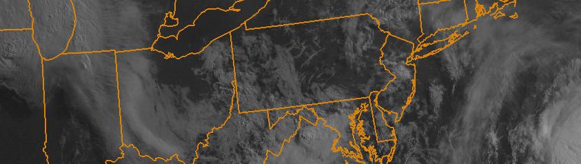
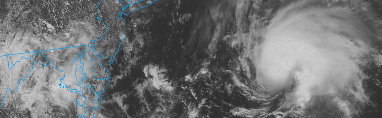
Tropical Storm Claudette formed this afternoon, amid a noticeably quiet Atlantic Hurricane Season, to the south of Nantucket. Claudette had been monitored by the National Hurricane Center for the past several days as a potential disturbance, and today it obtained the tropical characteristics necessary to be classified as a Tropical Storm with maximum sustained winds over 45miles per horu.

The Tropical Storm won’t be a threat to any United States shores, however. A developing mid level atmospheric trough will act to steer the system seaward over the next 12 to 24 hours. At the same time, atmospheric shear will increase and the system will head toward cooler ocean waters. Subsequently, weakening is anticipated as Claudette moves northeast in the next 24 hours.

Read more

Morning Roundup: Changeable weather returns

The weekend hangover is real. Monday morning brings change to a weekend which featured a stretch of incredible summer weather. Highs topped out in the mid to upper 80’s each day, with an offshore flow and only some high clouds at times. The sun was shining for the majority of the time — with Saturday and Sunday both turning out to be winners. Monday, still, will remain generally pleasant. A few showers and storms may pop up late, but we aren’t expecting any threat for organized storms. The same can’t be said for the middle of the week, beginning on Tuesday. A deepening trough in the mid levels of the atmosphere will bring more moisture, the return of an onshore flow with clouds, and chances for showers and storms for the next few days. Some highlights from around the meteorological community are included below:

  • Pleasant and warm conditions will continue today, especially during the first half of the day. Highs in the 80’s are expected again and, initially, offshore winds will keep the weather pleasant. During the second half of the day, increasing clouds will be a harbinger of unsettled weather — with showers and storms possible.
  • A severe weather outbreak is possible today across the Central Mississippi Valley. A very impressive complex of thunderstorms broke out overnight with widespread severe winds, and moved through Chicago this morning. The storms will drop southeast and strengthen again today. These are forming along the northern edge of a heat ridge over the Central Plains.
  • An onshore flow will develop Monday Night with a changing wind direction. Increased moisture and cloud cover will move inland from the area waters. Temperatures, as a result, will be a bit cooler during the middle part of this week.
  • A coastal system may develop during the middle part of the week as a deepening trough moves into the Northeast US. Showers, clouds and storms will remain possible until the system departs later in the week.

Morning Roundup: Beautiful weather weekend is here

It’s been a while since we’ve been able to safely say that a weekend of straight-up beautiful weather is on the way. Thanks to a post-frontal airmass characterized by relatively warm air and favorable wind direction, this weekend will be a winner. High temperatures in the mid to upper 80’s with plentiful sun and a light breeze are the highlights to dwell on this weekend. Water temperatures at the area shores are finally warming up a bit, too, so heading down to the beach this weekend is highly recommended. Perhaps the most notable of weather changes will be the lack of showers and storms, due to decreased atmospheric moisture. I think we all will enjoy the break after an unsettled week! Here are some weekend highlights:

  • Beautiful weather on both Saturday an Sunday, with high temperatures in the mid to upper 80’s and plenty of sun. Maybe some high clouds on Saturday morning, especially farther south as s coastal system skirts by. Comfortable winds — including an offshore flow — will keep any disruptive seabreeze or thunderstorm development at bay (no pun intended, we promise).
  • Rip currents and seabreezes, as mentioned above, will be a lower than normal risk. The onshore flow helps to keep these calmer than usual. Sunday, we could see a slightly more prominent current along the shores as the wind direction will start to shift.
  • Unsettled weather will, unfortunately, return for Monday. Winds turn south and then southeasterly, with showers and clouds returning by the second half of the day. It looks like the week ahead will be unsettled, too. But lets not dwell on it for now.

Afternoon Update: Enhanced risk of severe weather in PA, NJ

Strong to severe thunderstorms remain a distinct possibility this afternoon and evening across much of Eastern Pennsylvania and New Jersey. As a low pressure system moves quickly through New York State today, southerly and southeasterly winds will draw in warmer, more moist and unstable air. The incoming atmospheric disturbance will act to touch off thunderstorms, and these storms will form in an environment featuring instability and favorable shear. Accordingly, they may organize to strong and severe levels. The main threat with these storms will be damaging wind gusts, but an isolated tornado cannot be ruled out given the aforementioned atmospheric shear.

The threat for storms is much less as one travels farther east. Marine air near the coast will make New York City the dividing line for strong storms and weak storms — with thunderstorm complexes expected to weaken as they approach New York City and move toward Long Island. Still, thunder/lightning and heavy rain are likely over these areas. Highlights from today are included below:

  • The Storm Prediction Center has placed Western NJ and Eastern PA in an “Enhanced Risk” for severe storms this afternoon. An Enhanced Risk is issued when organized thunderstorms are possible, with the potential to produce locally damaging winds, hail, or isolated tornadoes. The Enhanced Risk is meant to signify the area where more concentrated severe weather may occur relative to its surroundings.
  • The risk for severe weather decreases as you head farther east. More stable air will be in place near the coast, thanks to south/southeasterly winds off the water. Still, some thunderstorms and a period of heavy rain is expected in New York City later tonight.
  • The weather will dramatically improve Friday into the weekend. As this storm system slides off the coast, a high pressure will build in. Temperatures will remain warm, with lots of sun, and very little chance for any precipitation.

*This post will update throughout the afternoon with details and information on thunderstorms.