Warmup with showers, storms on Friday

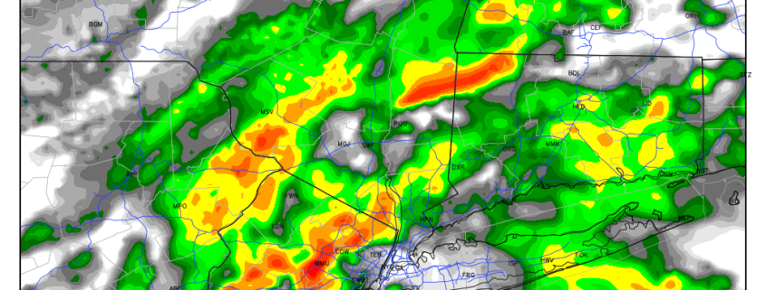
Despite a large mid level ridge, a backdoor cold front made any semblance of warmth exceptionally fleeting over the past few days. Thursday will be no exception, as east and northeasterly winds keep low clouds socked in with showers and drizzle dominating the forecast. Meanwhile, across the Central United States, a powerful cold front has begun its trek east from the Plains and will eventually end up in the Mississippi and Ohio Valleys by late Thursday and early Friday. Severe weather will be possible throughout the Central United States today.

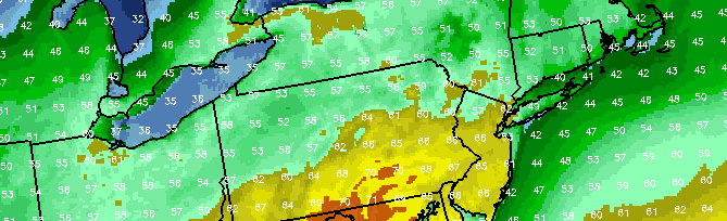
For our area, this signals two things: The end of any potential above average regime, and the likelihood of an increased southerly flow right ahead of the front. The latter of the two will be most important, as east/northeasterly winds will swing around to southerly on Friday. This will help to scour out the backdoor cold front and allow warmer air to surge northward from the Mid Atlantic States into parts of Southern New England. Temperatures will rebound, into the 60’s and potentially 70’s in much of New Jersey.

Read more

Backdoor cold front season is here, what’s the deal?

Each spring we emerge from a long cold winter with aspirations of 70 degree temperatures, a cool breeze and plenty of sun.  It rarely works out that way. Whether it be an upper level low, a stalled cold front, or a backdoor frontal boundary there are plenty of meteorological events that often are to blame for a colder and damp spring in this area. The fact of the matter is, our location during a transition season (fall, spring) is a difficult place to be. The changing and morphing wavelengths of the mid and upper level ridges and troughs mean the potential for cutoff lows, and the colder ocean waters this time of year especially will wreak havoc on any warmup.

This week, we will once again revisit the science behind a backdoor cold front. A significant low pressures system is forecast to develop through the Central United States during the middle part of this week, with the severe weather possible from the Plains into the Ohio Valley. Meteorology tells us that a warm front should be surging north from the Mid Atlantic states into New England as this low pressure moves towards the Great Lakes, with southerly winds ramping up warm air south of the  front. But where is the warm front, and why hasn’t it made progress north? The answer lies in the setup both aloft and at the surface, and it leads to the development of a backdoor front which will push the warm air back to our south during the middle part of the week.

Read more

Rain, fog, and thunderstorms tonight, clearing and windy Saturday

Today has seen a strong temperature gradient across the region. Out ahead of a cold front, there has been a persistent southerly flow, which has helped to warm the airmass. It has also allowed for a strong temperature gradient to form, as from NYC and westward, temperatures are in the 60s, but east of NYC, temperatures are primarily stuck in the upper 40s to low 50s with dense fog.

This is because as you go further east, the southerly winds have a strong fetch from the frigid Atlantic Ocean. This helps to cool temperatures off substantially in Long Island. Given that the airmass as a whole is somewhat warm and muggy, the cold low-level temperatures on Long Island end up being much closer to their dewpoints, which means a much more saturated low-level atmosphere. This has helped to create dense fog on Long Island, and this is expected to last for the rest of the day and night.

Further west, with surface temperatures a bit warmer but in the same airmass, fog will be patchy, but not as dense as it will be on Long Island.

As far as the rain is concerned, while a few scattered showers are possible during the next few hours, the area will be primarily rain-free for the evening and early-overnight, save for some fog-related drizzle. After midnight is when rain and some embedded thunderstorms could return.

Read more

Brief warmup ahead of late week cold front

After a cold start to the week, with snowflakes flying in New York City and light accumulations across the interior and higher elevations, temperatures will finally rebound during the middle to latter part of this upcoming week. High temperatures on Wednesday will reach into the 50’s, which will feel especially warm after the aforementioned early week weather. As a mid level ridge builds over the Northeast US from Wednesday Night into Thursday, temperatures will be given an additional boost — and may reach over 60 F for highs on Thursday afternoon.

Southerly winds will be the main culprit in bringing the warm air into our area, and so the usual concern will arise: Temperatures won’t be nearly as warm near the coast and on Long Island as they will be from New York City Westward. Yet, the air will be more moist and humid — so it will certainly feel like Spring regardless of where you are.

Read more