Transition weekend, stormy conditions next week

After strong to severe storms blew through the area on Wednesday evening, Canadian high pressure is back in control on Thursday. Cooler than normal air will slide back into the area over the next few days, with generally pleasant conditions. High temperatures in the 80’s will be more common than the 90’s from earlier in the week, but the lower humidity will make it feel much more comfortable. A transition in the pattern won’t occur until late this weekend into early next week, when unsettled weather will be poised to make a return.

As a mid level disturbance slides eastward through the Great Lakes, actually a part of a larger upper level trough, a warm front will slide northeastward from the Ohio Valley through the Northeast US. This will be the first sign of forthcoming unsettled weather, as increasing temperatures and forcing along the front will aid in the development of storms as early as Sunday morning. Multiple disturbances moving northeastward through the area will provide chances for storms on Sunday — but the main event would come on Monday as a low pressure system shifts through the Northeast US.

GFS model showing disturbances in the mid levels of the atmosphere approaching the area early next week.

GFS model showing disturbances in the mid levels of the atmosphere approaching the area early next week.

Read more

Transition day today leads to a nice end to the week

The cold front that had helped to cause the thunderstorms and heavy downpours over the past couple of days is finally working its way through the area, which will gradually clear our skies as the day goes on. However, the front will be slow to move through the area, given the strong western Atlantic ridging. Combining this with an extremely powerful mid and upper level disturbance, placing us in the right-entrance region of the jet stream, there will still be plenty of clouds around and some showers, with locally heavy downpours. That being said, considering the cold front has shifted to the east, the biggest threat for heavy rain should stay to the east of NYC.

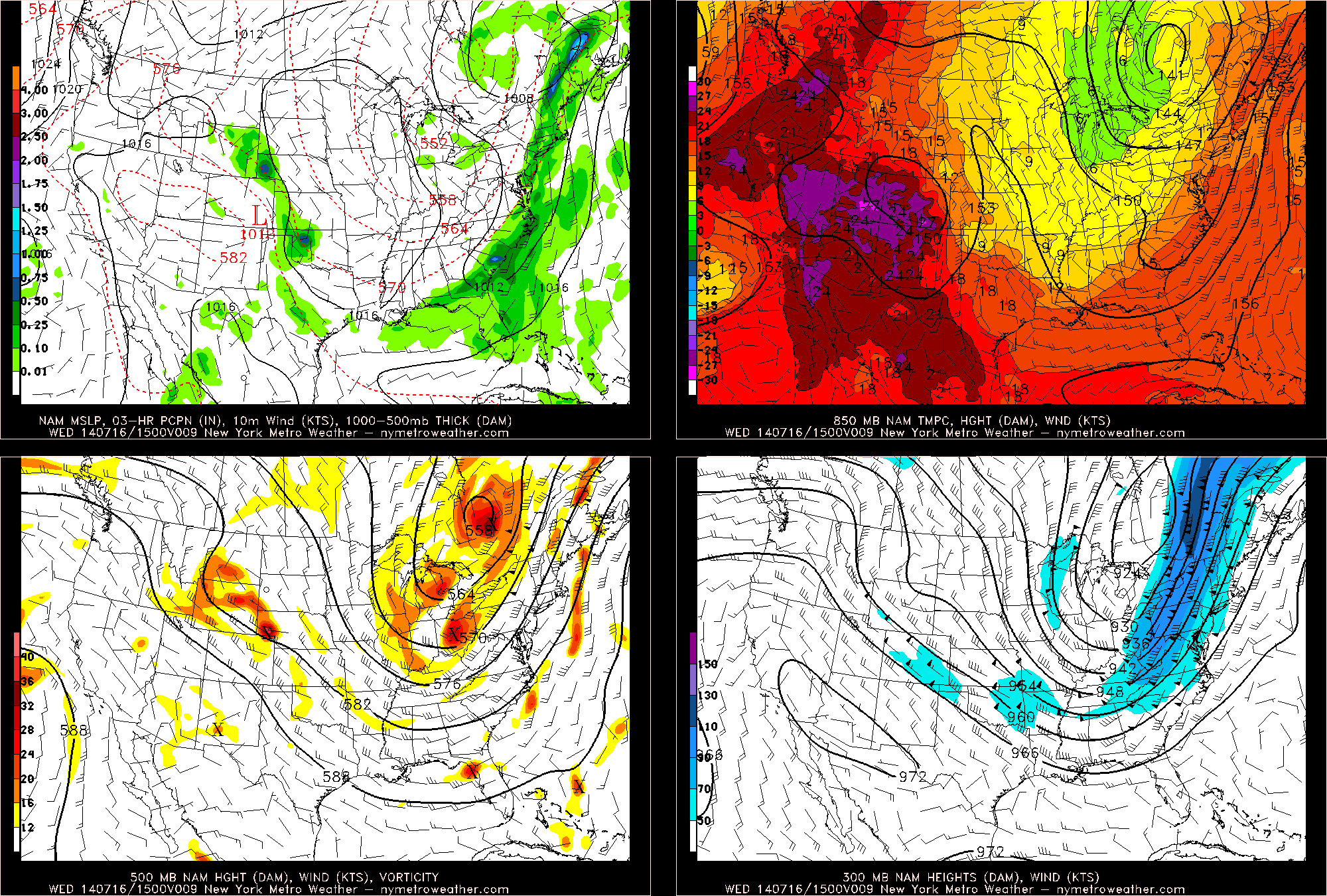
4-panel plot of this morning's NAM run, valid for 10:00am. Precipitation still hangs around the coast, with a cooler airmass behind it (top-left), a closed 850mb low in SE Canada leads to very chilly readings in the upper Midwest (top-right), a powerful 500mb low with strong vorticity that helped provide our messy weather still lingers (bottom-left), and a powerful jet streak at 300mb leads to upward vertical motion for clouds and rain (bottom-right). (New York Metro Weather Models)

4-panel plot of this morning’s NAM run, valid for 11:00am. Precipitation still hangs around the coast, with a cooler airmass behind it (top-left), a closed 850mb low in SE Canada leads to very chilly readings in the upper Midwest (top-right), a powerful 500mb low with strong vorticity that helped provide our messy weather still lingers (bottom-left), and a powerful jet streak at 300mb leads to upward vertical motion for clouds and rain (bottom-right). (New York Metro Weather Models)

The powerful 500mb low is actually a piece of the Polar Vortex, which explains why it is so strong and is bringing chilly temperatures to the Midwest, where temperatures even fell into the 30s this morning! Out ahead of it, strong southwest flow persisted for days, providing a conveyor belt of moisture and instability for thunderstorms. Now that the cold front is finally moving eastward, the conveyor belt also shifts eastward, which puts a limit to the coverage of rain. Most of New Jersey should stay rain-free, but clouds will remain for most of the day, thanks to the 100 + knot jet streak shown in the bottom-right panel. Long Island may have to deal with some rain and locally heavy downpours as we head through the morning.

Read more

Severe thunderstorms likely this afternoon and evening

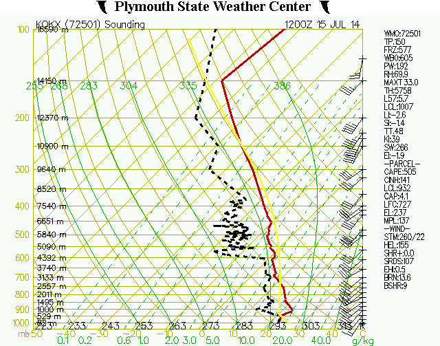
A morning sounding, gathered via data from a weather balloon launched at the NWS in Upton, New York showed a developing unstable environment — and sufficient wind shear for organization of strong and severe thunderstorms. An approaching disturbance in the mid and upper levels will aid in the development of strong to severe thunderstorms, which will be fueled by a moderately unstable environment throughout the area. Organized thunderstorms will be capable of producing strong and damaging winds, frequent lightning, and very heavy flooding rains.

Additionally, an increase in storm relative helicity and low level shear suggests the potential may exist for downbursts and isolated tornadoes. If individual supercells can form, this threat could be somewhat greater. Storms are expected to develop over Eastern Pennsylvania this afternoon and shift eastward through NJ, NYC, SE NY and CT. With strengthening wind fields, just above the surface, any storm could produce the aforementioned damaging winds and severe-weather impacts.

Morning sounding from the weather balloon launched at Upton, NY.

Morning sounding from the weather balloon launched at Upton, NY.

Read more

Severe weather, heavy rain likely Monday

As an expansive, powerful upper level low will shift eastward from the Great Lakes toward parts of the Ohio Valley late this weekend into early next week. Immediately, the southerly flow ahead of it — and the nature of the upper level low shifting so far south this time of year — caught forecasters eye for severe weather potential in the Northeast US.  The combination of warm, southerly flow ahead of the approaching upper level low will at least support the potential for heavy rain, while the severe weather setup has become more complicated.

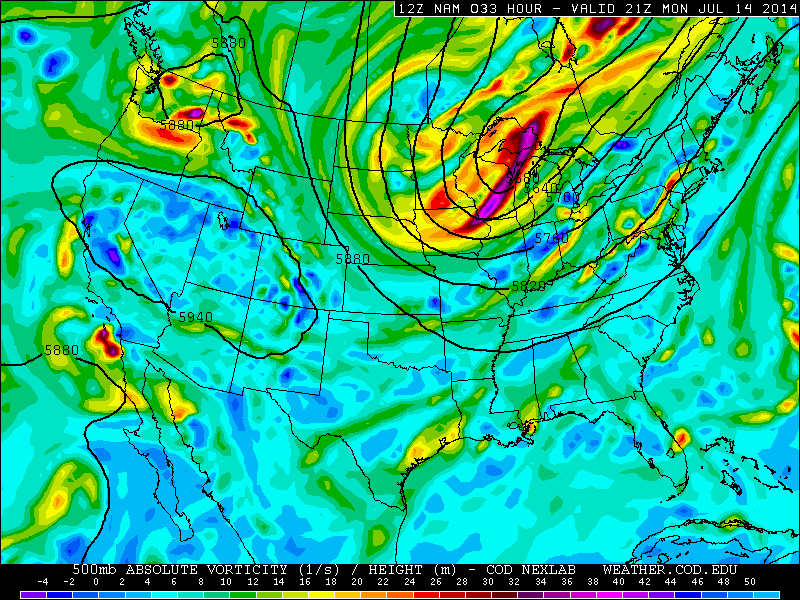
Sunday evening, the first “threat” for thunderstorms will develop over Pennsylvania and Western New York state, where lift for thunderstorm development and instability will support severe storm potential. These storms will move eastward toward parts of our area later tonight, but are expected to weaken over time as they lose support for organization. On Monday, however, things will change — as southerly flow strengthens in our area, shear aloft increases, and lift develops during the afternoon to aid in the development of thunderstorms. Figure 1 shows the approaching upper level system.

Figure 1 - NAM model showing the upper level system shifting toward the area on Monday.

Figure 1 – NAM model showing the upper level system shifting toward the area on Monday.

Read more