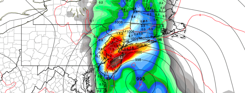
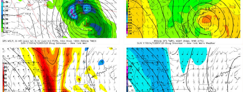
Impactful coastal storm likely this weekend

A happy Wednesday afternoon to you! Relatively calm and stable weather has settled into the Northeast states over the past few days, despite the presence of a cold trough lingering over the region. Higher pressures have remained in control, with only a few weak and dissipating disturbances meandering nearby. This has kept the weather quiet, albeit cooler than normal, and created a bit of a facade in front of how the atmosphere is truly behaving as this week goes on.

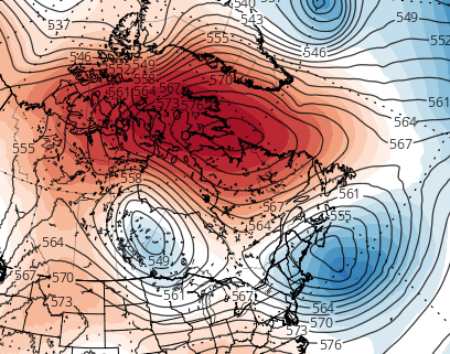
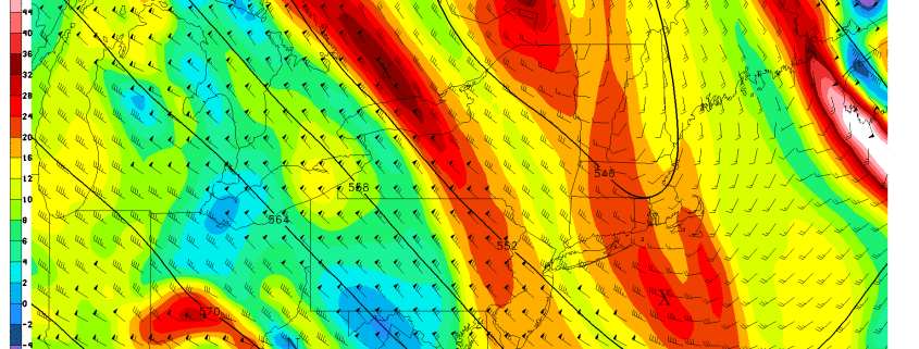
In truth, the hemispheric height pattern is in quite a disturbed state as we speak this afternoon. A potent, anomalous high latitude block has developed from Greenland into Central Canada, disrupting the wave pattern and height field throughout the Northern hemisphere. This has led to the development of one of the strongest -NAO’s on record for the month of May, and is the impetus behind the colder than normal air which has settled into the region this week.

Read more

Midday Zones Update: Cool Weather Through Friday, Weekend Coastal Storm Threat Increases

Happy Tuesday afternoon! Some sunshine will continue for rest of today. But we will continue be under the influence of a large, anomalous cold upper-level low or trough over the Northeast US. This will lead to more cumulus clouds developing, instability increases with more daytime heating.  A few isolated showers could also pop up, but these will be over more Connecticut or New England today. Temperatures will rise in the upper 50s to lower 60s.

Read more

Impressive blocking will lead to cool, stormy pattern in Northeast

High latitude blocking is a term most often referred to in winter. The reasons for this are multi-faceted; its presence often leads to snowy and cold patterns during the Winter months, and dreary, wet patterns in the Spring months. Meteorologically, the latter is a far less popular outcome. However, popularity put aside, impressive high latitude blocking events can occur in any season. And when they do, their presence most often disrupts the pattern throughout the entire hemisphere.

This week’s high latitude blocking event will be no different. Ridging will build from Greenland westward into parts of Eastern and then Central Canada (an extremely negative NAO index, for those keeping score), remaining highly anomalous as it does so. In fact, the standard deviation from normal in the atmosphere’s mid levels makes this block one of the most anomalously impressive features on the globe at this time.

Read more

PM Zones: Warmth on Hiatus

Good afternoon! We continue to have chilly weather with a mix of sun and clouds, thanks to a large blocking pattern forcing an upper-level low to linger over the area. The upper-level low has a very chilly airmass underneath it, particularly from 850mb and above. In fact, this chilly airmass led to snow in Norfolk, CT this morning! Generally, highs only held in the upper 50s across the area, and it actually could’ve been worse had it not been for downsloping NW flow and deep mixing in the atmosphere. But the NW flow and mixing makes the surface warmer, which increases the difference between the surface temperatures and the very chilly airmass aloft, which increases atmospheric instability, and leads to an increase in clouds — thus the frequent periods of cloud-cover today. These clouds also contained a few isolated showers, but the downsloping component kept these a bit more infrequent than days past.

Read more