Sunday Overview: Warmth today followed by showers and possible t-storms this evening

Today has gotten off to beautiful, warm start for this time of year!  A weak cold front slowly moving through the region is cause some clouds to mix with sunshine this morning. But dry conditions remain as lift is currently too weak this front. Some sunshine with more west-southwest winds, will help temperatures rise into the lower or middle 70s over much of region this afternoon. Which around 10 degrees warmer than normal for the end of October.

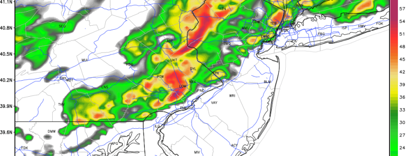
However, a wave of low pressure developing along the cold front will enhance more lift,-leading to more cloud cover and numerous showers around the region later this afternoon and evening. A widespread, heavy rainfall is not currently anticipated. But with the airmass becoming warmer and unstable, some showers and thunderstorms with heavy downpours and frequent lightning are possible. The Storm Prediction Center even has marginal risk for isolated thunderstorms with damaging wind gusts for parts of West-Central NJ and Eastern PA. Stay tuned for updates on our social media accounts today. Premium members, check back for more updates on this system on the main dashboard today, as well. Skies will clear later tonight, as this system moves out of the region. Some other highlights for the next few days:

Read more

The stratosphere, Pacific Jet, and a changing hemispheric pattern

A hemispheric pattern change is underway, and the effects will be felt throughout the United States quite quickly over the next few weeks. A dramatic change in wind speed and temperature in the stratosphere — near the very top of the Earth’s atmosphere — over the past few days, has re-shuffled the pattern throughout the troposphere — where most of our weather is observed. This is especially true in the higher elevations, nearer to the poles, where the stratospheric vortex typically resides. The disruption to the stratospheric vortex will have implications on the pattern throughout the Northern Hemisphere.

Here’s the thing: The stratospheric vortex is fickle. It extends from the troposphere to the stratosphere, so simply disrupting it or moving it won’t have dramatic implications. But what’s happened over the past few days, and what will occur through next week, is more than that — forecast models continue to indicate that the stratospheric vortex will be completely split throughout multiple levels. When the stratospheric vortex splits into two, dramatic implications can occur throughout the higher latitudes. Even if they don’t occur immediately, the splitting stratospheric vortex can lead to a domino effect which changes the pattern down the road.

Read more

Premium: Winter weather impacts in Northeast US this week

A dynamic storm system is expected to track through the Northeast United States later this week, bringing with it the opportunity for some frozen precipitation, particularly on the front end as the storm develops. This will be especially true in the interior and higher elevations, before warm air changes precipitation over to rain. Nearer to the coast, mostly rain is expected, although a brief burst of frozen precipitation isn’t out of the question in the suburbs and higher elevations there as well.

The storm system will be operating and gaining steam from “warm air advection” in the mid levels of the atmosphere. Moisture surging toward the Northeast US on Thursday will provide increasing lift for precipitation as warm air moves into the atmospheres mid levels. The atmosphere will quickly become too warm for frozen precipitation near the coast, but colder air will hang on a bit longer in the interior. This will lead to a complicated forecast.

Read more

Premium: Inland freeze tonight, incoming storm Thursday

High pressure from Canada will allow cold air to surge into the area over the next few days, an airmass will be characterized as unusually cold even for late October. After mostly sunny skies this morning, some atmospheric instability with daytime heating and moisture aloft will lead to more clouds mixing in with sunshine this afternoon. High temperatures throughout the NYC Metro Area and the Northern Mid Atlantic will reach into the middle 50’s, with continually breezy conditions thanks to a tight pressure gradient with a low pressure over the Canadian Maritimes.

Skies will clear during the evening hours tonight, and winds will become lighter overnight as instability diminishes with the loss of daytime heating, all as very cold air seeps into the area from the northwest. This will support very cold temperatures overnight and by daybreak on Wednesday, temperatures will have dropped into the middle and upper 30s over NYC and other urban and coastal areas. Many of the suburbs will drop into the lower to middle 30s, with some middle to upper 20s possible over parts of over the interior and higher elevations. This could lead to a freeze with some patchy frost in those areas that have not experienced frost or freeze yet this cold season. Therefore, the National Weather Service has issued Freeze Warnings for many of the inland suburbs tonight and even Frost Advisories for urban areas around Philadelphia.

Read more