-2")
Atlantic Becomes Hyperactive, Irma Still a Potentially Catastrophic Category 5 Hurricane
Good Evening!
The Atlantic has grown quite a bit from the past few months, from only being able to produce short-lived storms, to producing a record-shattering Category 5 and two more hurricanes simultaneously! The last time that there were three active hurricanes in the Atlantic was back in 2010. Depending on the timing of each system, we may even have a slight chancre at seeing two or even three major hurricanes at once, a sign that conditions have really changed across the basin.
——————————————————————————-
Starting from the right, we have Hurricane Jose, which formed yesterday from an elongated area of low pressure associated with a tropical wave a couple days after Irma formed. Since yesterday, Jose has very steadily become more organized, with expanding upper level outflow, deep convection, and even a small eye popping out every once in a while. The system is currently in a pocket of light wind shear of around 10-15 mph, but there are some indication that the extremely large upper level outflow from Irma is blowing some of the thunderstorms to the east of the center, which may keep further intensification at a more gradual pace for the next 24 hours. Jose is in a weak area of steering relative to its position, so the movement of the next few days is expected to be generally west northwest before an upper level trough to the north of the system causes the storm to speed up a bit and even back away to the east by the weekend. This timing with the trough will be very important, since the hurricane is expected to be rather close to the same islands that Hurricane Irma devastated, and any deviation west in the track would result in the storm potentially affecting the islands. Environmental conditions around 15N look quite favorable for the storm to intensify into the seasons third major hurricane of the year, with the ECMWF, GFS, and HWRF all showing the storm becoming a strong hurricane in about 5 days.
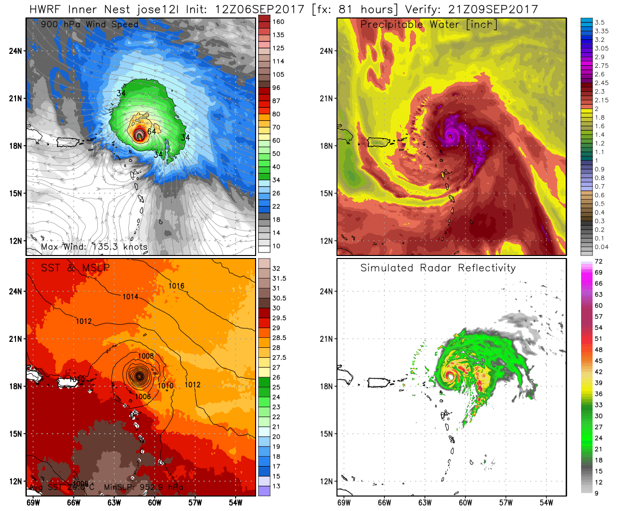
This afternoons HWRF model showing Jose very close to the islands that were just affected by Irma (Courtesy of Weatherbell)
By Monday, the storm should be well north of Puerto Rico and Hispaniola and over the open ocean. At this time, most of the reliable model guidance has steering once again breaking down, and we could see the storm once again drift to the east, but this time for a more prolonged period of time. If Jose were to drift underneath the subtropical ridge as it moves eastward, it would likely stick around for quite some time as it would have to wait for another trough to pick it up and drag it north. Land impacts for this system are low, but the Lesser Antilles should monitor the progress of this system due to the impacts of Irma. Overall, it looks like Jose will be a storm that should generally head out to sea over the next five days or so, then meander for at least another five days.
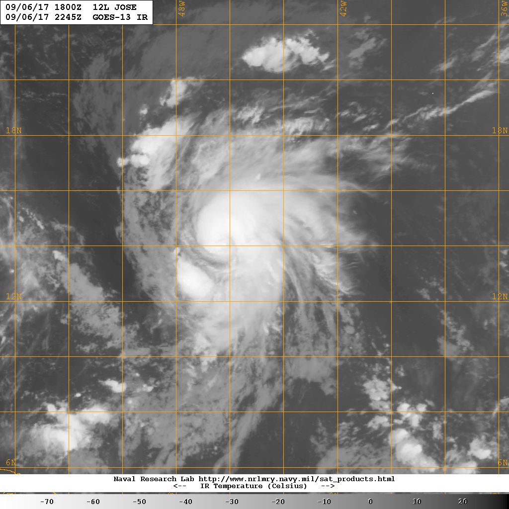
Infrared Satellite Imagery of recently upgraded Hurricane Jose over the Central Atlantic. Note the lack of upper level cirrus clouds on the western half of the storm due to the outflow from Hurricane Irma (Courtesy of Navy NRL)
We now move on to Katia, which was designated as a tropical storm early this morning (around 5am) and has since rapidly intensified throughout the day, becoming a 75mph hurricane over the Bay of Campeche. Katia seems to have formed from a tropical wave interacting with the tail-end of a cold front draped across the southern Gulf of Mexico and into the Bay of Campeche. Given the time of year, how warm the ocean is, and the concave geography of the area, it really is no surprise that the system has taken off like it has. The system is attempting to establish a southern outflow channel which is helping to ventilate the system, but the same cold front that spawned Katia is also producing a very high amount of wind shear on the northern side of the system. This shear should keep Katia from organizing too rapidly, but again with very warm waters and the southern outflow channel, it seems that the system should be able to organize gradually for the next 24 hours. After that, the system to begin to sink to the south and west, where shear may be substantially lower than it is right now. This could allow the system to organize more rapidly as it nears landfall late Friday and into the early morning hours of Saturday. With resources limited due to near-constant surveillance of Hurricane Irma, we may have to rely on satellite estimated for intensity, but regardless, I feel that the system has a medium potential to reach Major Hurricane status before making landfall on the Mexican coastline.
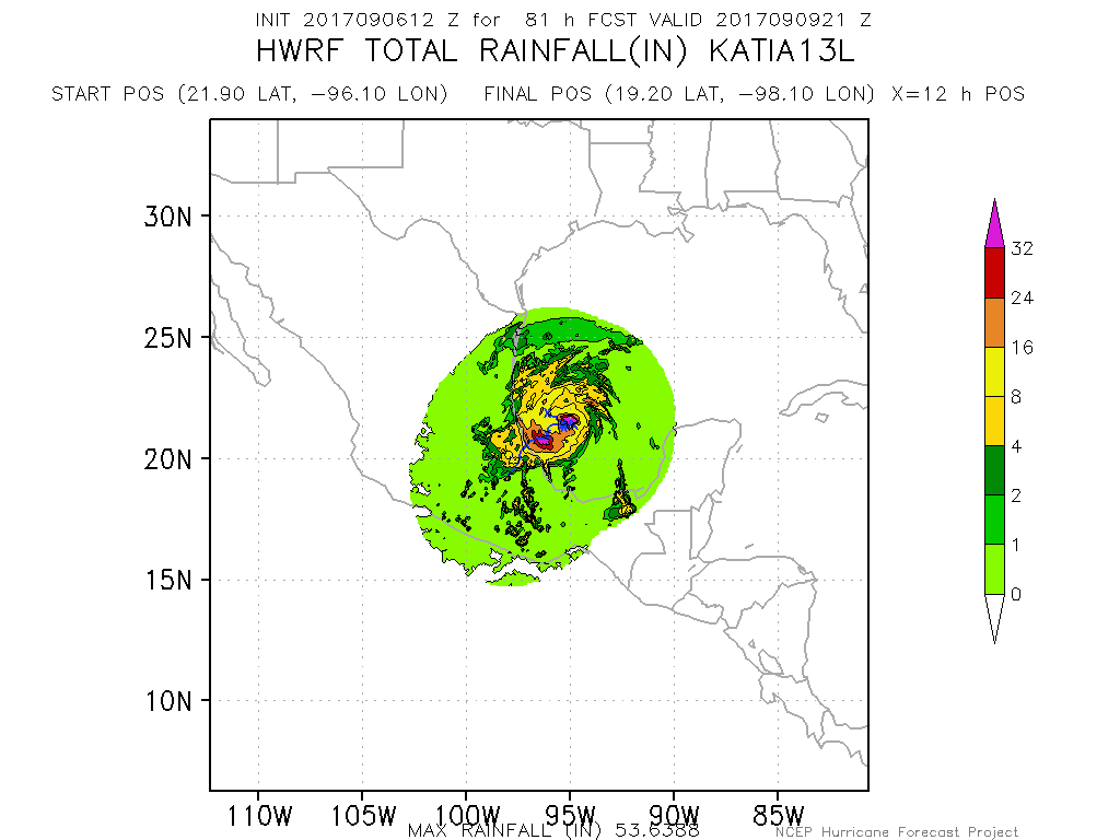
This afternoons rainfall projection from the HWRF model showing very heavy rainfall amounts just off the Mexican coastline. Katia will need to be monitored closely for a potentially deadly mudslide event (Courtesy of NOAA HRD/HWRF)
The primary threats from Katia will be extremely heavy rainfall capable of triggering deadly mudslides. Winds will also be a secondary concern depending on just how strong Katia can get, but due to the history of the region, the rainfall threat supersedes this.
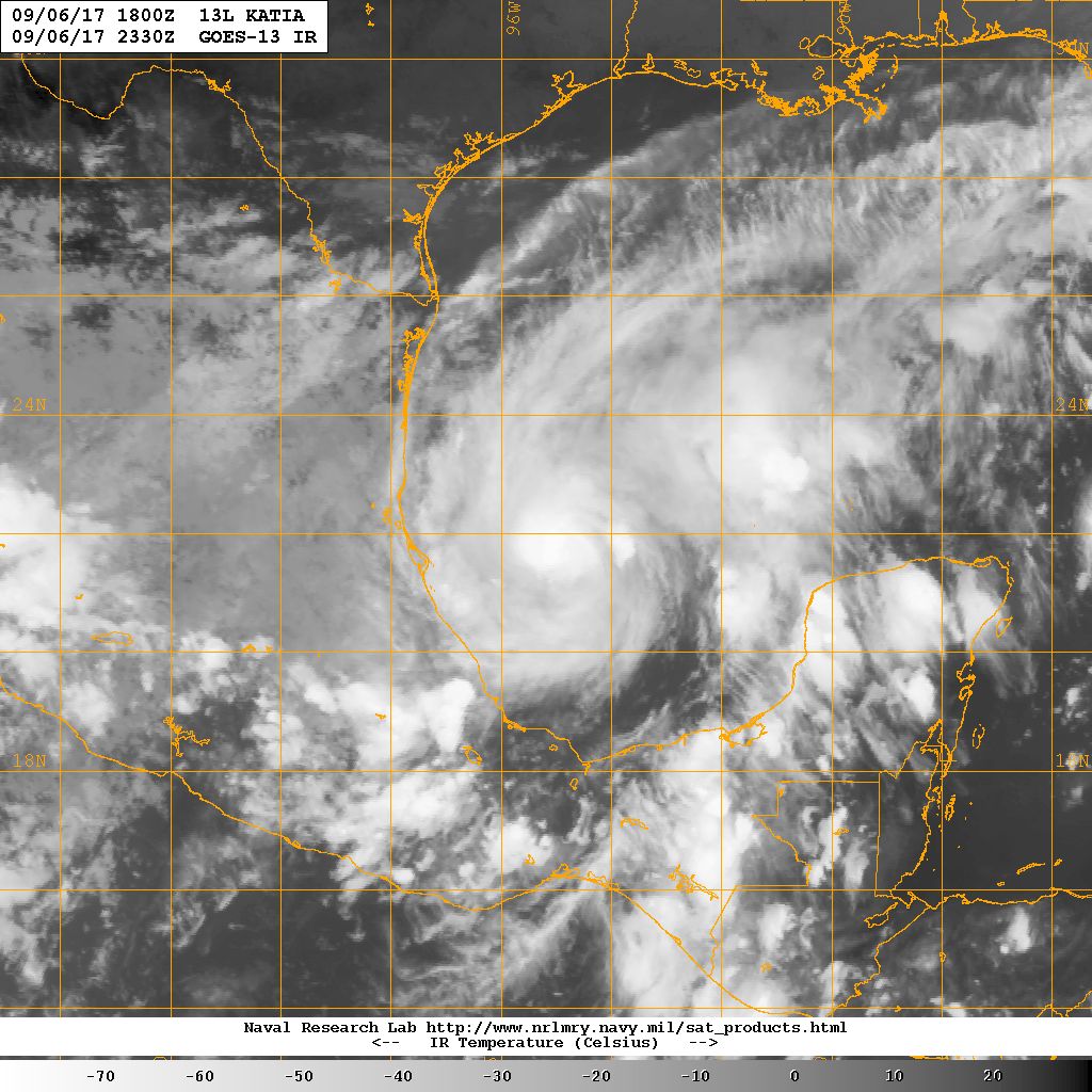
IR shot of recently upgraded Hurricane Katia in the Bay of Campeche. Katia is likely to strengthen as it heads southwest over the next few days
Now for the main-ticket item…
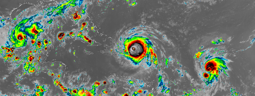
Hurricane Irma has blown past all expectation over the past 24 hours after it rapidly intensified into a 185 mph Category Five storm just east of the northern Lesser Antilles. This is the strongest ever recorded hurricane outside of the Caribbean and Gulf of Mexico, and the eye of Irma went over the northern Leeward Islands last evening with devastating impacts. At the time of this article, there are no reliable fatality reports, but images and ground reports indicate that at least 90% of all infrastructure in Barbuda has been destroyed. An automated weather station reported wind gusts up to 155 mph shortly before being destroyed. Other islands have not reported much over the past 12 hours, likely due to the fact cell towers have quite literally been bent in half and destroyed.
Since moving through the islands, Irma has battled with some westerly shear in the mid levels of the atmosphere and even some dry air, but this did not halt the beast from once again dropping pressure back down to the 916mb level (down from the 920’s). Irma once again has good to excellent outflow in all quadrants, and very cold convection surrounding the eye. There are some indications on radar that the storm may be about to go through another eyewall replacement cycle, which may temporarily weaken the system. While the system may temporarily weaken, once the new eyewall forms, the windfield in the hurricane will likely expand quite a bit, which is what we have seen happen ever since this system left Africa.
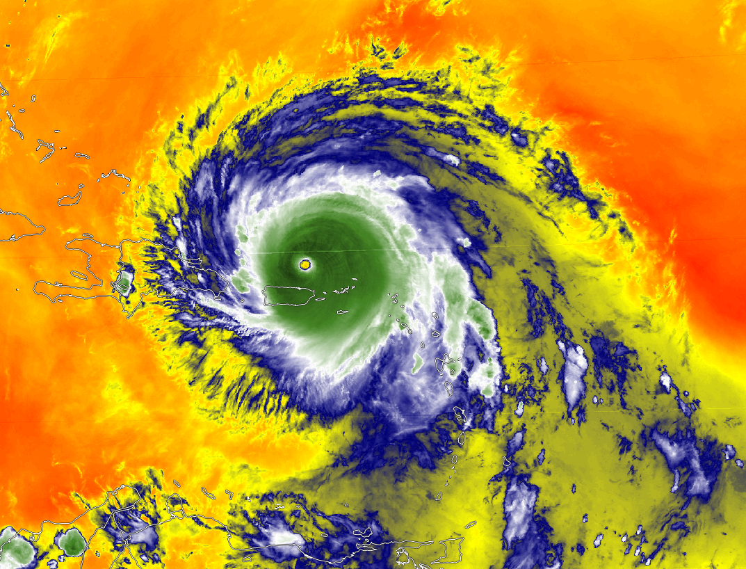
Water Vapor imagery of Hurricane Irma with winds up to 185 mph winds. Notice the wispy blue clouds expanding from the north and south, indicative of a very favorable environment.
Irma is located just to the north of Puerto Rico this evening and should continue heading west-northwest over the next 36 hours, near the coast of Hispaniola. This is an interesting position and situation, because the very large circulation of the hurricane will be interacting with the very tall mountains of the island. Depending on how close the center gets to the coast of Hispaniola, there may be some downsloping winds, which are cool winds coming down from the mountains and into the circulation of the storm. This is a topic that is not well modeled or talked about by the National Hurricane Center, but has the potential to weaken the storm for a small period of time. After the storm pulls away from Hispaniola, it should be nearing the southern Bahamas early Friday morning and into Saturday.
Conditions will be extremely favorable for the hurricane, with very warm waters of 30-32C, low shear, and a very moist environment. Even if Irma does weaken down to a Category 3, I see no reason why the storm would not be able to restrengthen into at least a Category 4 by Saturday. It is looking like Saturday also will be the critical point for the storm regarding whether or not it will directly impact Florida. The old solutions of the storm interacting with Cuba, and then potentially heading up the west coast of the state are now unlikely, and we now have a rough consensus that the storm will likely affect the eastern half of the state in some shape or form.
This afternoons model guidance suggests that once Irma is just north of the Cuban coast, a mid level disturbance in the central Plains will begin to rapidly drop south and into the Ozarks. This mid level system will begin to interact with Irma, bringing it northward by late Saturday. The key point in this forecast is just how far west Irma can get before it begins to interact with the mid level system. IF it is farther west than forecast, then the western half of Florida will likely feel the brunt of Irma. IF the storm is east, then it may scrape the east coast of Florida and eventually impact the east coast. This will be the crucial point in the forecast to focus on, and we likely wont know the exact details for a bit of time. However, the threat of Irma impacting south Florida is significant enough that those in the path should begin preparations by going over their hurricane plans, or potentially beginning to evacuate if you feel you need to do so or are told to do so. At this time, it seems that the chance of Irma impacting the US is almost unavoidable, and those from the Florida Keys to all the way up to North Carolina need to closely follow the progress of this system!
****When making decisions, always consult the National Hurricane Center, your local National Weather Service, government officials, and local Emergency Managers.****
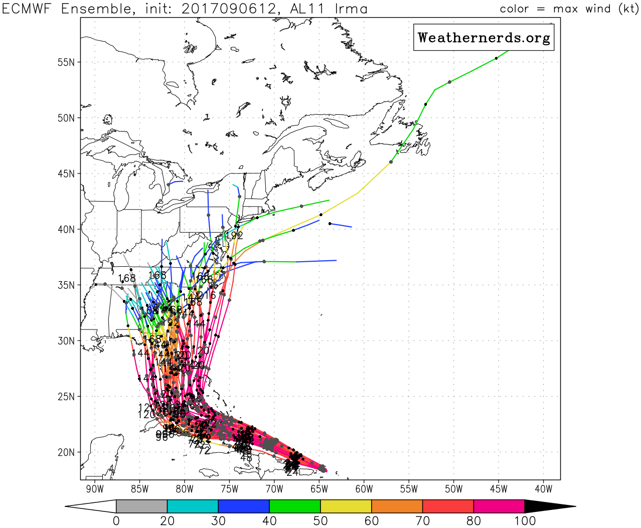
This afternoons European Ensembles showing a variety of tracks, but with the vast majority of the members impacting Florida, as well as other states along the East coast (Courtesy of Weathernerds.org)
We will have another update on all three storms on Friday! If you are in the path of the storm, please remain alert and be prepared!
For more information and posts like this one, make sure you sign up for Premium Forecasts — where multiple detailed articles, videos, and interactives are posted each day. Also, come interact with our staff and many other weather enthusiasts at 33andrain.com!
Have a great evening!
Steve Copertino