Winter hiatus expected to close out December

Before we start, to sign up for daily articles (like this one) videos, discussions, interactives and more, contact our team here.

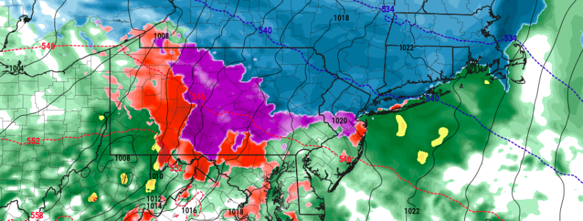
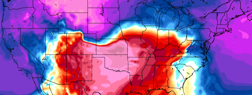
After a two week period featuring a polar vortex intrusion, colder than normal temperatures, and frequent winter weather opportunities (especially in the interior) the pattern this week will be one of transition. The hemispheric pattern is undergoing some fairly significant changes, which are working to take then cold air back to its source region by late this week, over the arctic and north pole.

Yes, the arc is swinging back the other way, as the same cold air which was disrupted and pushed southward into the Northern 1/3 of the United States is retreating fairly dramatically. In the stratosphere, the polar vortex is tightening and strengthening over the North Pole, a dramatic difference from the vortex we observed earlier in the season which was stretched, nearly split, and elongated.

Read more

Threat Analysis: Weekend winter storm

A well discussed storm system — with winter weather potential — is heading towards the Northeast US this weekend, in the wake of a brutally cold airmass associated with the polar vortex in the troposphere. This storm, however, will come with a vast amount of warm air advection — which occurs when warm air moves in multiple levels of the atmosphere. In this case, southwesterly winds are driving the storm system towards the Northeast as the polar vortex departs.

The resulting storm system will be one of transition, with a cold airmass in place to start, followed by a moist and warm airmass as the storm begins its departure. The transition itself will occur with quite a bit of complexity, and interior locations are likely to see a impactful winter storm on Saturday, particularly in the morning hours. Nearer to the coast, a change to rain should occur relatively quickly, alleviating widespread impacts.

Read more

Weekend storm system will start wintry in Northeast

An arctic airmass will drive southeastward from Canada and into the Northeast United States late this week, bringing with it the coldest temperatures in quite some time. In fact, the arctic airmass is part of the polar vortex — yes that one which we discuss all too often — a piece of which is dropping southward into New England. This isn’t necessarily unusual in winter, but it certainly is this time of year — some of the temperatures being modeled at 850mb (5000 feet) would challenge record lows for this time of year.

Nevertheless — the polar vortex swinging through will, after it brings some brutally cold air, begin a quick departure. This is occurring mainly due to a lack of high latitude blocking. In other words, there is no feature to “keep” the polar vortex from shifting away, and back to where it typically stays. There was an impetus to bring it here, the Alaskan ridge which we discussed at length the past several weeks.

Read more

Wintry weather likely in the Northeast Sunday into Monday

A much discussed storm system will finally make its trek east through the United States this weekend, arriving in the Ohio Valley and Northeast United States from Sunday into Monday. An initial disturbance pushes eastwards on Sunday, shearing out and weakening but still providing the impetus for some preliminary wintry weather. The more significant disturbance waits until Sunday Night and Monday to impact the Northeast US, bringing with it a significant amount of moisture and lift for precipitation. Snow is expected to shift northeastwards from the Ohio Valley gradually as Sunday evening goes on.

That’s where the complications begin: A surge of warm air associated with the system will be battling a departing high pressure, which will be on borrowed time as it moves away into the Atlantic Ocean. This spells the likelihood of mixed precipitation and transitioning precipitation types after a start as snow, especially near the coast where wintry precipitation amounts will be extremely limited. But inland, where cold air is expected to be more stout, a few inches of snow are possible before the changeover.

Read more