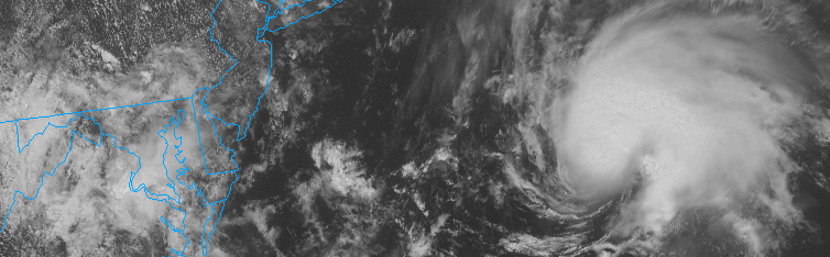
Tropical system, blocking will lead to forecasting headache

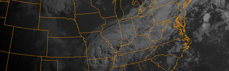
It has been a while since the meteorological community has had the chance to analyze the potential for higher latitude blocking. It has also been a while since we’ve had the opportunity to analyze a synoptic heavy rain event. Both of those look to come to fruition, in multiple facets, over the next five to seven days. A dramatic pattern change will unfold across North America this week, with anomalously strong ridging and surface high pressure building into Canada and the Northwestern Atlantic Ocean. Precariously timed with the formation of a tropical cyclone, this blocking high pressure will lead to a forecasting headache — and the potential for heavy rains and impacts from a Tropical Storm along the East Coast.

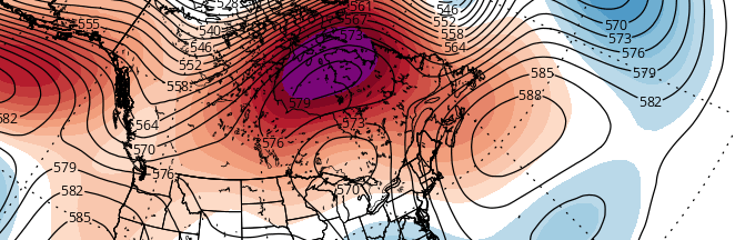
For those without a technical background, high latitude blocking is a broad term for higher then normal pressures/heights in the higher latitudes. These “blocking” ridges of high pressure to our north, sometimes over Canada and the Atlantic and sometimes as far north as parts of Greenland, slow down the weather pattern closer to our area. The slower weather pattern can allow disturbances to interact and phase — forming much larger, more powerful storms that otherwise would have continued on their own way if the pattern was moving at a normal progressive speed.

This week, forecast models are in agreement that higher latitude blocking will develop over much of Canada into the Northern Atlantic Ocean. Ridging builds into these areas in the mid levels of the atmosphere, and a very strong surface high pressure builds east and southeast into Canada and even parts of New England. This is one important piece to the forecast headache, and one reason why meteorologists are slightly more concerned than normal at this range: The tropical system, or storm system that forms, cannot simply escape north or northeast. The blocking will slow down the pattern considerably.

Read more

T.S Erika, and her future over the next week

It is always interesting, this time of year, when a Tropical Storm or Hurricane forms to the east of the Lesser Antilles. While, obviously, no two meteorological patterns are exactly the same, tropical systems that form in this general area seem to have a tendency to catch the attention of those on the United States East Coast and Gulf Shores. It’s no surprise, really, given the history of such storms making landfall somewhere within the United States. An equal amount of systems, still, recurve “harmlessly” out into the open Atlantic Ocean or, in the case of Hurricane Danny just days ago, succumb to shear and unfavorable atmospheric conditions and die.

Tropical Storm Erika (with a “K”) formed last night in the Tropical Atlantic Ocean, with maximum sustained winds of around 45 miles per hour. Erika is expected to continue on a generally northwest heading over the next few days, gradually strengthening as she heads toward the Bahamas. Intermittently poor atmospheric conditions (albeit, no prolonged periods of strong shear) should keep the strengthening “Gradual” without any rapid intensification.

Read more

TS Claudette forms, expected to head seaward

Tropical Storm Claudette formed this afternoon, amid a noticeably quiet Atlantic Hurricane Season, to the south of Nantucket. Claudette had been monitored by the National Hurricane Center for the past several days as a potential disturbance, and today it obtained the tropical characteristics necessary to be classified as a Tropical Storm with maximum sustained winds over 45miles per horu.

The Tropical Storm won’t be a threat to any United States shores, however. A developing mid level atmospheric trough will act to steer the system seaward over the next 12 to 24 hours. At the same time, atmospheric shear will increase and the system will head toward cooler ocean waters. Subsequently, weakening is anticipated as Claudette moves northeast in the next 24 hours.

Read more

TS Bill’s remnants still an uncertainty this weekend

Much has been made over the past few days in regards to the potential for heavy rain on Sunday. The remnants of Tropical Storm Bill are anticipated, by many forecast models, to move northeastward from the Ohio and Mississippi Valley’s into the Northeast States. A weak developing surface low near the area of the mid level disturbance is expected to aid in the development of heavy rain from the Mid Atlantic northeastward toward parts of the Northeast as well, as the system shifts toward the coast.

The problem, however, is that remnants of Tropical systems are unpredictable by nature. The high moisture, high energy, and intricate nature of the pattern in the mid levels of the atmosphere makes it very difficult on forecast models to try and pin down specifics. For us, this means an uncertain weekend forecast. And, yes, the potential that Sunday may turn out to be not quite a washout at all.

Read more