A technical look at Tuesday’s snow
[s2Member-PayPal-Button sp=”1″ ids=”3795″ exp=”72″ desc=”Purchase this post for $.99″ ps=”paypal” lc=”” cc=”USD” dg=”0″ ns=”1″ custom=”www.nymetroweather.com” ra=”0.99″ image=”default” output=”button” /]
-2")
[s2Member-PayPal-Button sp=”1″ ids=”3795″ exp=”72″ desc=”Purchase this post for $.99″ ps=”paypal” lc=”” cc=”USD” dg=”0″ ns=”1″ custom=”www.nymetroweather.com” ra=”0.99″ image=”default” output=”button” /]
A wintry mess was the most fitting way to describe the morning commute on Monday as snow, sleet, and freezing rain provided a myriad of issues with travel. Traffic, accidents, and delays on the area roads and with local mass transit likely lead to a headache for most — if you were able to get in to work or class without an issue, consider yourself lucky. The ice and wintry precipitation caused closures of schools and businesses over the interior, but coastal and urban locations including the NYC Metro were much warmer by morning — allowing for a more wet commute than white.
The disturbance moving through the area will shift northeastward on Monday, ending with scattered showers throughout the area. Colder air will begin to filter in rapidly behind the system on Monday Night. As an early warning, you’ll want to be extra careful on the evening commute and during any overnight travel as well. The falling temperatures could lead to re-freezing of any water on roadways and other surfaces.
But our problems don’t end there. Forecast models have come into better agreement on another disturbance which will shift northeast through the area on Tuesday. Much colder air will have moved into the area both aloft and at the surface, so this storm system looks to provide less difficulties in forecasting precipitation type: Mainly snow. Bands of snow will develop by late morning into afternoon on Tuesday, accumulating initially across the interior ( a little slower to do so on the coast and in the city with warmer ground and surfaces).
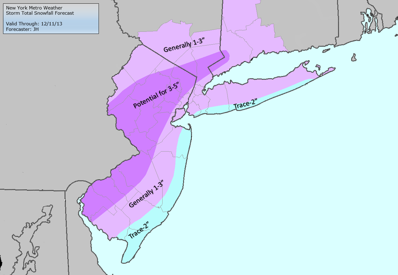
Storm Total Snowfall forecast through Tuesday evening. Please note that forecasts are subject to change prior to the event.
Although the big snowstorm that some models had for Wednesday night and Thursday is definitely not going to happen, the NYC Metro area may still see its first snowflakes of the season tomorrow morning during the rush-hour commute. Yes, this does include coastal areas.
The main culprit for this is the Arctic cold front that will move through the area. There is not a whole lot of moisture with this front, as the main story will be the falling temperatures, as temperatures will struggle to get out of the 30s tomorrow and Wednesday. However, there is some moisture; particularly behind the front, where temperatures will be colder. This is called an anafront, as opposed to the more typical katafront, where most of the moisture is out ahead of the front in the warmer, more unstable airmass.
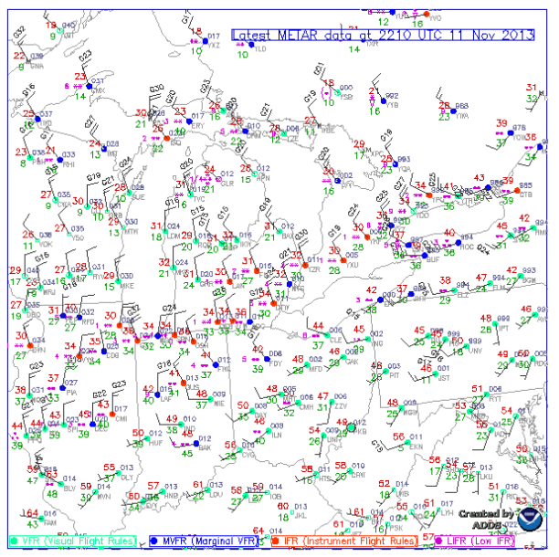
Current surface observations in the Great Lakes show the frontal boundary quite well, with many observations of snow on the cold side of the boundary. This front will cross our area during the overnight hours and should give most of the area its first snowflakes of the season.
Normally, it is much easier to generate precipitation ahead of a front rather than behind it, due to the airmass being warmer and having more moisture ahead of the front. But sometimes, due to jet stream dynamics among other things, the best source of lifting actually occurs behind the front. Of course, the colder airmass and lack of a strong storm system will somewhat mitigate the amount of precipitation that does fall; but the temperature gradient, lift, and moisture aloft do support some precipitation.
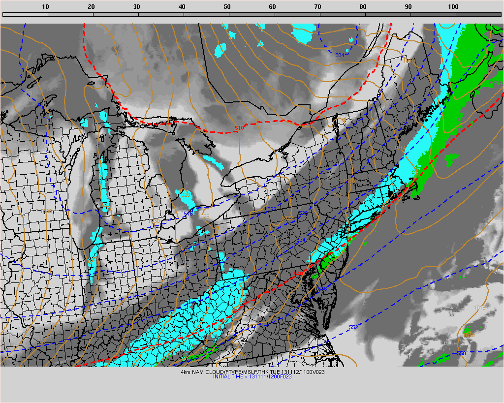
This morning’s high-resolution NAM model shows a band of light to moderate snow moving into the area around 6:00 a.m.
Precipitation should start as light rain around 2:00am in further northwest areas, and closer to 4:00am in coastal locations. As temperatures cool, the rain should change to snow about an hour or two after the initial onset of precipitation, fall lightly to at times moderately, and then end between 9:00am and 11:00am from west to east. This means that the immediate NYC Metro area could see a period of steady snow between 6:00am and 7:00am. Accumulations will be very light and limited to only the cold surfaces. Perhaps a dusting to a coating in coastal sections, and a coating to as much as an inch further north and west. The main roads should primarily be just wet, but it may be a good idea to save a bit of extra time tomorrow morning, as some colder roads could be a bit white and slick. It may appear quite wintry at times, due to the strong winds blowing around any snow that does fall.
As some of you may have heard, there is speculation going on about a potential winter storm next Wednesday and Thursday. Snowfall maps from various computer models, such as the European model, have been posted on numerous social media pages. Some of these maps have shown accumulating snow all the way down to the I-95 corridor, leading some to hype the potential for snow. Is this hype justified?
At the end of our previous post, we hinted that there could be a pattern-change coming towards mid-month as a cold air source builds in NW Canada and slides towards the United States via a strong cold front. It turns out this cold blast of air may be more significant than originally anticipated, as this source of cold air has little room to modify as it traverses through the Canadian snowpack. With this cold air push along with warm air still existing to the south, the temperature gradient is ripe for a potential storm system to form. Whether it forms out to sea, takes a track too far west and brings warm air and rain to our area, or takes a track off the coast and brings a snowstorm is yet to be determined.
What is causing this storm to be possible and where is the cold coming from?
It all begins with the Pacific and a unique blocking event near the Aleutian Islands. A very strong ridge is forming there, and what happens downstream of that ridge may become quite interesting.
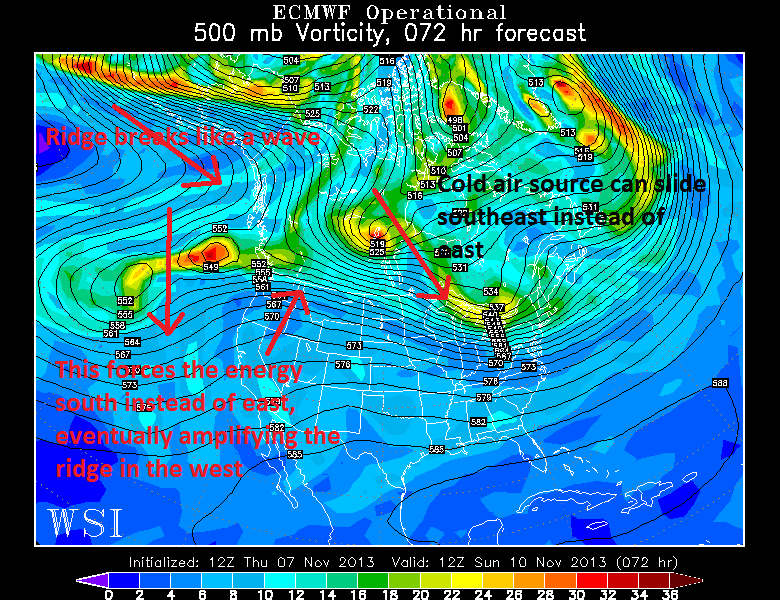
Today’s (11/7) 12z European Model run valid for Sunday morning shows why a storm system with cold air is possible. Image credit goes to the WSI Model Lab.