Confidence in a significant snowstorm is increasing for Thursday night and Friday

As colder air begins to filter in over the next few days, the weather pattern will become more favorable to support a snowstorm for later this week. While details still remain a bit uncertain, the trends in all of the latest model guidance support the threat for a potentially high-impact snow event.

Although December was a pretty active month as far as winter storms were concerned, there were no major, widespread snowstorms for the entire area. The main reason for this was the lack of any North Atlantic blocking, which helped to keep the flow in the pattern too fast for any major, organized amplification. However, this time around, some North Atlantic blocking has developed. Although it is not tremendously strong, it is located in a perfect position to slow down the pattern and support a major storm. Let’s go over all the pieces in the latest model guidance.

Today's 12z European Model at the 500mb level valid for Tuesday evening shows several key pieces which could help produce a big snowstorm. Image credit goes to the WSI Model Lab.

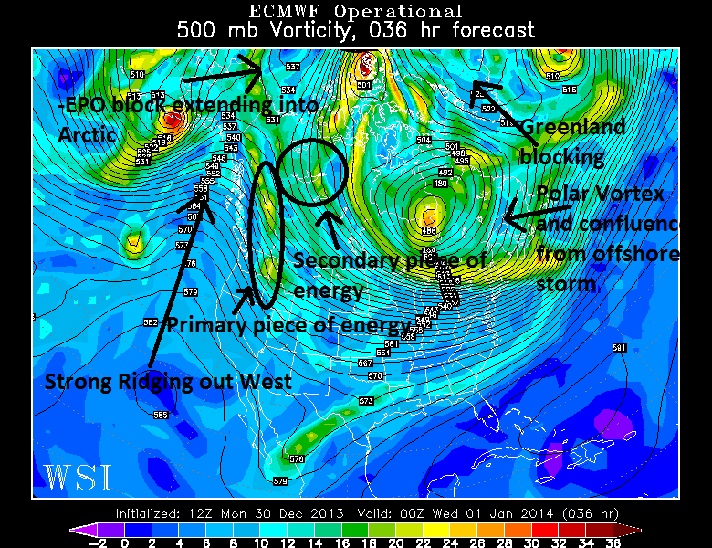
Today’s 12z European Model at the 500mb level valid for Tuesday evening shows several key pieces which could help produce a big snowstorm. Image credit goes to the WSI Model Lab.

The image above shows today’s 12z European Model at the 500mb level, valid for Tuesday evening. There are several key pieces labeled which indicate the potential for a big storm. Although the storm itself is still a few days away, the fact that this setup is in place within 36 hours gives us a bit higher confidence in a snowstorm of some kind.

Read more

Cold and dry start to the week, more snow follows

A bitterly cold start to the morning on Monday will serve as a reminder that winter is off to an early start, as if the multiple snow events in the past two weeks weren’t enough. Cold weather is expected to continue throughout the day on Monday as an arctic airmass is settled into much of the Northeast US and New England.  High temperatures in the upper 20’s are expected throughout the area on Monday, but it will end up feeling a whole bunch colder than that, thanks to blustery west winds. Real feel temperatures could remain in the teens throughout much of the interior, and maybe even New York City. It will feel a bit warmer close to the immediate coast.

The main story in the upcoming weather period, however, is the clipper system which is expected to deliver another shot of light snow to the area on Tuesday. A surface low associated with a mid and upper level disturbance is forecas to track just south of our area on Monday Night through Tuesday morning. Despite the progressive nature of the pattern, this could cause the development of a weak surface low south of Long Island. And such a development would all but certainly aid in the development of precipitation — likely falling in the form of snow across much of the area — early on Tuesday morning through the afternoon. You can view our latest snowfall forecast here.

NAM model showing a period of moderate snow throughout the area on Tuesday.

NAM model showing a period of moderate snow throughout the area on Tuesday.

Read more

PM Update: One storm out, another one in

It is often said in the meteorological world that “dry begets dry”. In this case, snow begets snow. Amidst a hemispheric pattern which has historically been unfavorable for snow, multiple snowstorms have driven through the Northeast United States over the past two weeks. Most recently, for obvious reasons, is the snowstorm which occurred just this past Saturday Night into Sunday and left a significant snowfall accumulation in many areas, especially Northern New Jersey, New York City and Southeast New York into Connecticut. But even prior to that, a rare significant December snowfall over Philadelphia and Central New Jersey got winter off to a surprisingly fast start.

Saturday and Sunday’s event was certainly the most significant so far on this young winter’s season, with a significant snowfall and then icing across the interior. It was also the most interesting from a mesoscale perspective, with a dramatic coastal front and mid level warm air advection changing areas over to sleet and freezing rain despite surface temperatures in the 20’s. Regardless, after several inches of snow most areas changed over to rain. The cold air held on longer inland, and was much quicker to scour out near the coast. You can access our official verification map, with plotted totals over our forecast, right here. Attention now turns to a clipper type storm system, which will swing through the area on Tuesday — and forecast models are beginning to hone in on the potential for another light snowfall.

High resolution NAM model showing a period of moderate snow throughout the area on Tuesday morning.

High resolution NAM model showing a period of moderate snow throughout the area on Tuesday morning.

Read more

Live: Significant winter storm set to impact the area

Link Hub: Latest Watches and WarningsSnowfall Map | Snowfall Probabilities

The National Weather Service issued Winter Storm Warnings and Winter Weather Advisories which were valid from Saturday through Sunday, in advance of a major winter storm which is forecast to impact the area. Beginning later Saturday, snow is expected to spread throughout the region from southwest to northeast. The snow will likely be light initially, as it battles with drier air. But as a disturbance moves northward and eventually develops a stronger surface low near the Mid-Atlantic coast, heavy precipitation will move towards the area on Saturday afternoon and evening.

Temperatures, both aloft and at the surface, remain a major challenge for forecasters and will have a significant impact on how the event shakes down. Warmer temperatures aloft are expected to begin to move into Southern and Central New Jersey by later Saturday afternoon, and progress northward through the evening. At the coast, this will spell the end for frozen precipitation, as the warm layer’s depth expands and surface winds turn southeast off the warmer ocean waters. But inland, the battle will just be beginning, as the warmer air moves in aloft but is forced over the top of a shallow cold layer which remains stubborn near the surface. The combination could lead to snow changing to sleet and freezing rain across parts of the area suburbs, resulting in not only a moderate snowstorm, but significant icing thereafter.

Latest storm total snowfall forecast, including what has already fallen. Updated 11am 12/14/13.

Latest storm total snowfall forecast, including what has already fallen. Updated 11am 12/14/13.

Read more