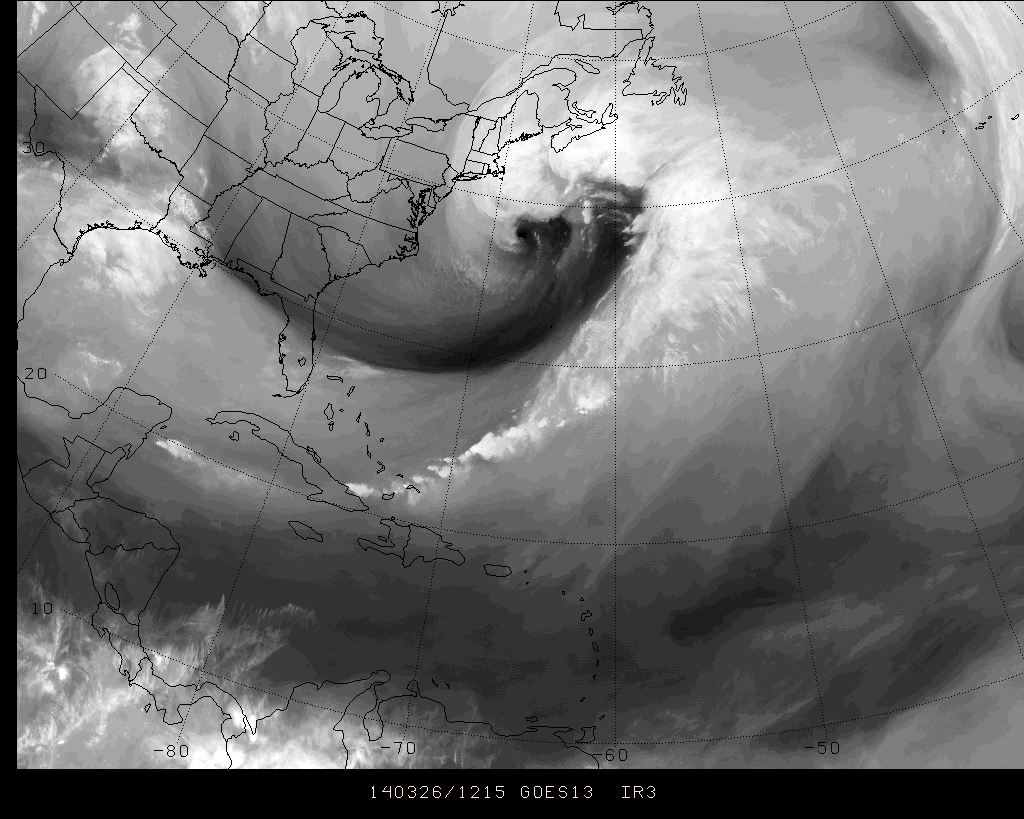
What may eventually be the strongest Nor’Easter in the past 20 years or more is currently developing to the south and east of New England, deepening rapidly to some of the lowest pressures observed in a non-tropical storm system in the Northwest Atlantic on record. Although the storm system spared our area major impacts, parts of Cape Cod and especially Nantucket are feeling the brunt of the developing low pressure system. We’ll follow along today and post some of the latest images, information and news as it comes through.
Water Vapor satellite imagery showing massive storm system in the Northwest Atlantic
A high impact storm system will affect the area beginning later Wednesday evening, and continuing throughout much of Thursday. Significant amounts of snow, periods of rain and sleet, gusty winds and coastal flooding are all expected hazards. Wednesday night a strong storm system will develop off the Carolina coast, owing to a powerful mid and upper level trough and shortwave. Phasing disturbances aloft will eventually reach the East Coast, which will help shift the coastal system north and eventually northeastward from the Mid Atlantic to the shores of New England.
With significant impacts expected, we have opened up our live blog for discussion throughout the overnight period beginning at 7:00pm February 12th, 2014. Throughout this time, our meteorologists will check in and continue to update the live blog (and the website products, of course) with information. Even better, the live blog will feature our staff’s thoughts on the event as it is unfolding. This way, you’re never in the dark when it comes to the forecast or the storm which is evolving. Keep it right here tonight and during the storm on Thursday. We have included some handy links to our recently issued products below, followed by the live blog below that. Note: We are using a brand new software, so bear with us if there are any kinks (and let us know, if you can). If we have any significant problems, we will revert to our basic text update system. (Click read more if you are on the homepage to see the live blog)
Colder, but more tranquil weather has settled into the forecast area to end the holiday week. After some light snow showers associated with a weak front and coastal system on Thursday, pleasant weather is expected on Friday and Saturday. Additionally, there will even be a bit of a warming trend both days, as high temperatures reach into the 40’s. The arctic air which stepped into the area earlier in the week won’t have any reinforcement until early next week, and so airmass modification will allow for temperatures to push warmer on both Friday and Saturday especially as the surface high pressure slips off the East Coast.
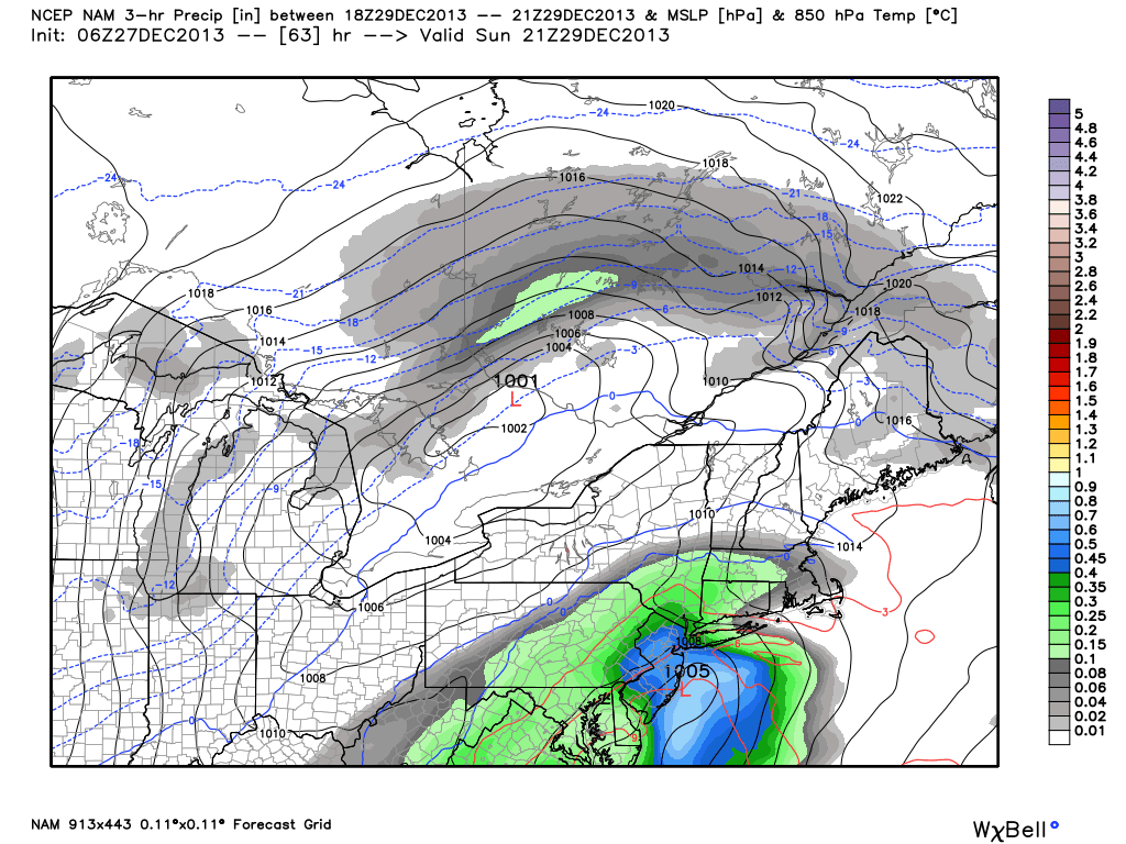
By Sunday, the weather becomes more active as a southern stream disturbance will slingshot up the coast. The system will ride on the eastern periphery of an incoming trough over the Central United States which, in its own right, will carry a ton of cold air with it. This means a few things, however. First, the system looks to be progressive despite its deepening off the coast. Second, the system will have plenty of warm air with it — and the cold air will have already modified out of the Northeast US. The aforementioned antecedent airmass won’t hold much potential for wintry precipitation. As such, the main concerns for this weekends system are a period of heavy rain and some gusty winds.
NAM model forecasting a coastal storm system on Sunday, providing the area with heavy rain.
https://www.nymetroweather.com/wp-content/uploads/2024/02/Empire-2000-x-300-px-2.png00John Homenukhttps://www.nymetroweather.com/wp-content/uploads/2024/02/Empire-2000-x-300-px-2.pngJohn Homenuk2013-12-27 08:54:072013-12-27 08:54:07Tranquil weather will give way to weekend nor’easter
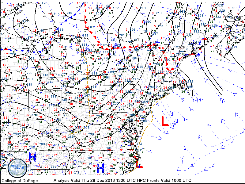
This holiday week has generally been characterized by the return of colder air (after quite a warm start from the tail end of the weekend) and chances for light snow. Much of the same will continue on Thursday, as temperatures in the 20’s to near 30 will be common during the afternoon and a weak disturbance passing through aloft will spark the development of snow showers throughout the area. The weak low pressure system forming offshore and the relative lack of moisture means that precipitation will be spotty at best — but nevertheless, some flakes should fly especially across New Jersey and much of the interior. Accumulations are expected to be extremely light.
Another cold night is expected from late Thursday into Friday, as the aforementioned developing low pressure system pulls down one more reinforcing shot of cold air. Low temperatures in the teens and 20’s should be rather common by early Friday morning. Despite the light snow over the past several days, the weather pattern has been generally quiet. But beginning with a storm system late this weekend, the activity looks to kick up once again as we make our way into January.
Northeast US surface analysis on December 26, 2013 showing a weak coastal low forming offshore.
https://www.nymetroweather.com/wp-content/uploads/2024/02/Empire-2000-x-300-px-2.png00John Homenukhttps://www.nymetroweather.com/wp-content/uploads/2024/02/Empire-2000-x-300-px-2.pngJohn Homenuk2013-12-26 09:25:152013-12-26 09:25:15Cold air, snow showers to close out the week
Hi friends! Our website uses cookies to provide an optimal browsing experience for you. New "Cookie Consent" laws mandate us to inform you of this. As long as you're cool with it, just hit OK. You'll only see this message once.
We may request cookies to be set on your device. We use cookies to let us know when you visit our websites, how you interact with us, to enrich your user experience, and to customize your relationship with our website.
Click on the different category headings to find out more. You can also change some of your preferences. Note that blocking some types of cookies may impact your experience on our websites and the services we are able to offer.
Essential Website Cookies
These cookies are strictly necessary to provide you with services available through our website and to use some of its features.
Because these cookies are strictly necessary to deliver the website, refusing them will have impact how our site functions. You always can block or delete cookies by changing your browser settings and force blocking all cookies on this website. But this will always prompt you to accept/refuse cookies when revisiting our site.
We fully respect if you want to refuse cookies but to avoid asking you again and again kindly allow us to store a cookie for that. You are free to opt out any time or opt in for other cookies to get a better experience. If you refuse cookies we will remove all set cookies in our domain.
We provide you with a list of stored cookies on your computer in our domain so you can check what we stored. Due to security reasons we are not able to show or modify cookies from other domains. You can check these in your browser security settings.
Other external services
We also use different external services like Google Webfonts, Google Maps, and external Video providers. Since these providers may collect personal data like your IP address we allow you to block them here. Please be aware that this might heavily reduce the functionality and appearance of our site. Changes will take effect once you reload the page.
-2")