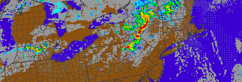
A complex atmospheric pattern is expected to unfold on Saturday, and the evolution may lead to the potential for strong to severe thunderstorms in the Northeast states. As a mid level ridge builds toward the area from Friday Night into Saturday, a disturbance associated with a thunderstorm complex in the Northern Midwest states will ride over the top of this ridge, eventually diving southeast from Southeast Canada into the Northeast on Saturday. But, as you can imagine, forecast models are struggling with the exact details of its movement through the area.
Convection, inherently, is difficult to forecast. Models are likely to struggle with this disturbance as thunderstorms develop today over the Northern Midwest and head toward parts of the Great Lakes. More importantly, this disturbance will move northeastward into Southeast Canada, along the periphery of a mid level ridge, and then dive southeastward into our area later Saturday — and the timing of its approach becomes critical to the forecast.
https://www.nymetroweather.com/wp-content/uploads/2016/06/Screen-Shot-2016-06-10-at-1.57.07-PM.png284834John Homenukhttps://www.nymetroweather.com/wp-content/uploads/2024/02/Empire-2000-x-300-px-2.pngJohn Homenuk2016-06-10 13:59:112016-06-10 13:59:11Strong storms possible Saturday, but uncertainty remains high
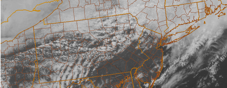
A warm front, associated with a wave of low pressure system over Northeast PA, has situated itself across the area this afternoon. Warmer temperatures exist to the south of the front, over Southern and Central New Jersey, where temperatures have already surged into the middle to upper 70’s. Farther northeast, colder marine air remains in place where temperatures are in the 50’s over New England. This warm front will serve as a focal point for the development of storms later today, as an upper level disturbance approaches the area.
Some of these thunderstorms may be strong to severe this afternoon, especially over Central and Southern New Jersey where stronger instability will develop. The Storm Prediction Center has issued a Slight Risk of severe thunderstorms for those areas. Meteorologically, this threat is supported by both kinematic and thermodynamic evolutions. Instability, on the order of 500-1000 j/kg of mixed layer cape, will support storm development once the upper level disturbance approaches. Mid level lapse rates may limit the threat of widespread severe weather (between 6.0 and 7.0 C), but steeper low level lapse rates in Central and Southern New Jersey, juxtaposed with favorable 0-6km bulk and speed shear may lead to some organized storms. The main threat with these storms, which will drop southeast through NJ and NY later today, will be damaging winds and hail. A weak tornado isn’t impossible, especially near the warm front with backing low level winds.
https://www.nymetroweather.com/wp-content/uploads/2016/04/headertho.png303782Miguel Pierrehttps://www.nymetroweather.com/wp-content/uploads/2024/02/Empire-2000-x-300-px-2.pngMiguel Pierre2016-04-26 13:13:182016-04-26 13:13:18Thunderstorms this afternoon may be strong with gusty winds
An approaching mid level disturbance will aid in the development of a low pressure system today, which will track from Pennsylvania to Southeast New York during the afternoon hours. Southeasterly winds at the surface will help to advect in warmer, more moist and unstable air during the afternoon hours. Near the coast, this low level wind flow will bring in a marine layer that will keep the air more stable. So, naturally, as the disturbance approaches the best chance for severe weather will be away from the coast and west of New York City. In those areas, from Pennsylvania to New Jersey, strong to severe thunderstorms will be possible. We’ve included some details and information below, but stay tuned for an updated article later today if any watches or warnings are issued:
Hot and humid once again today. Highs approach the upper 80’s after a cloudy start. Southerly winds will draw in a more moist and humid airmass, with more clouds along the coast and near the area beaches and local waters.
A disturbance approaching the area will bring the potential for strong to severe thunderstorms, mainly west of New York City. These storms will be capable of producing strong winds, lightning, flooding rains and possibly an isolated tornado.
A period of heavy rain is likely during the evening hours, even in New York City and near the coast. As the storms weaken and spread east, localized flooding will be possible with heavy rains.
Much nicer conditions are expected for Friday and into the weekend, as high pressure settles in. Temperatures will remain warm with plenty of sun and a very minimal chance of any precipitation.
https://www.nymetroweather.com/wp-content/uploads/2015/07/forthetop.png210750John Homenukhttps://www.nymetroweather.com/wp-content/uploads/2024/02/Empire-2000-x-300-px-2.pngJohn Homenuk2015-07-09 08:00:322015-07-09 08:35:42Morning Overview: Strong storms possible this evening
12:30pm: This morning, we initially had a strong area of showers and rumbles of thunder in Pennsylvania that was moving toward our area. if it hit us, the atmosphere would have stabilized and the severe threat for thunderstorms would have significantly gone down.
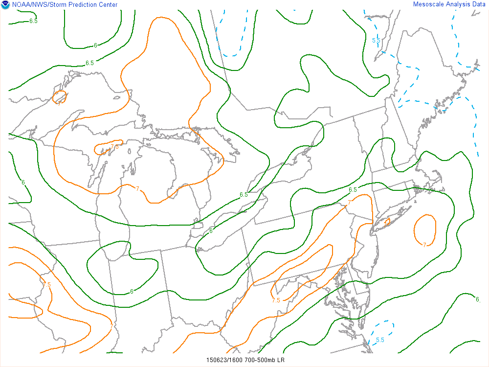
Current SPC Mesoanalysis as of noon shows an area of mid-level lapse rates in excess of 7C/KM in our area. This is very significant, as it leads to plenty of instability in the middle of the atmosphere, as well as providing a capping inversion below it that weakens any weak convection and keeps us sunny and unstable.
However, the EML we discussed yesterday was able to work its way into the region and provide a capping area that completely disintegrated this area of showers. This means that clouds will quickly be disintegrating, and we will quickly be able to destabilize the atmosphere, making it very ripe for severe weather.
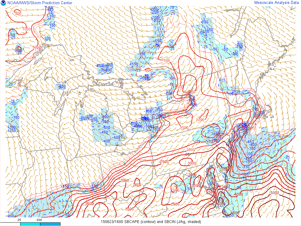
Current Mesoanalysis from the SPC shows already building values of surface-based CAPE.
In fact, surface-based CAPE values are already in excess of 3,000 J/KG in many areas, which is actually ahead of schedule. When this is combined with the strong mid-level lapse rates and strong wind shear, severe weather is expected to hit a decent chunk of our area later this afternoon. The primary threat will be damaging wind gusts and vivid lightning, but large hail is also a threat, and a tornado threat is non-zero.
—–
An energetic mid level disturbance, impressive wind shear, and moderate to significant atmospheric instability will combine to create an enhanced threat for organized severe thunderstorms in the Northeast US on Tuesday. While some uncertainties still exist in regards to exactly how the event will unfold, confidence is rising in the heightened threat for severe thunderstorms — even in the NJ and NYC Metro Area. While not everyone will experience a severe storm, the threat for organized thunderstorms is much higher than normal today.
Thunderstorms are forecast to develop over Northern Pennsylvania and New York State, and begin progressing southeastward throughout the day. Meanwhile, atmospheric destabilization will occur over much of New England, the NYC Metro, New Jersey, and the Mid Atlantic. Instability parameters are expected to be quite high, especially by Northeast US standards. With more than adequate wind shear for thunderstorm organization, these storms are expected to spread southeast toward the coast during the late afternoon and evening.
This post will serve as a Live Blog throughout the day for updates and information on the latest analysis as well as a relay point for Watches and Warnings from the Storm Prediction Center and Local NWS offices. A de-brief on the threat is below:
https://www.nymetroweather.com/wp-content/uploads/2015/06/Screen-Shot-2015-06-22-at-11.25.00-PM.png240756John Homenukhttps://www.nymetroweather.com/wp-content/uploads/2024/02/Empire-2000-x-300-px-2.pngJohn Homenuk2015-06-23 07:20:112015-06-23 12:38:35Severe thunderstorms possible this afternoon and evening
Hi friends! Our website uses cookies to provide an optimal browsing experience for you. New "Cookie Consent" laws mandate us to inform you of this. As long as you're cool with it, just hit OK. You'll only see this message once.
We may request cookies to be set on your device. We use cookies to let us know when you visit our websites, how you interact with us, to enrich your user experience, and to customize your relationship with our website.
Click on the different category headings to find out more. You can also change some of your preferences. Note that blocking some types of cookies may impact your experience on our websites and the services we are able to offer.
Essential Website Cookies
These cookies are strictly necessary to provide you with services available through our website and to use some of its features.
Because these cookies are strictly necessary to deliver the website, refusing them will have impact how our site functions. You always can block or delete cookies by changing your browser settings and force blocking all cookies on this website. But this will always prompt you to accept/refuse cookies when revisiting our site.
We fully respect if you want to refuse cookies but to avoid asking you again and again kindly allow us to store a cookie for that. You are free to opt out any time or opt in for other cookies to get a better experience. If you refuse cookies we will remove all set cookies in our domain.
We provide you with a list of stored cookies on your computer in our domain so you can check what we stored. Due to security reasons we are not able to show or modify cookies from other domains. You can check these in your browser security settings.
Other external services
We also use different external services like Google Webfonts, Google Maps, and external Video providers. Since these providers may collect personal data like your IP address we allow you to block them here. Please be aware that this might heavily reduce the functionality and appearance of our site. Changes will take effect once you reload the page.
-2")