Forecast: Unsettled week lies ahead

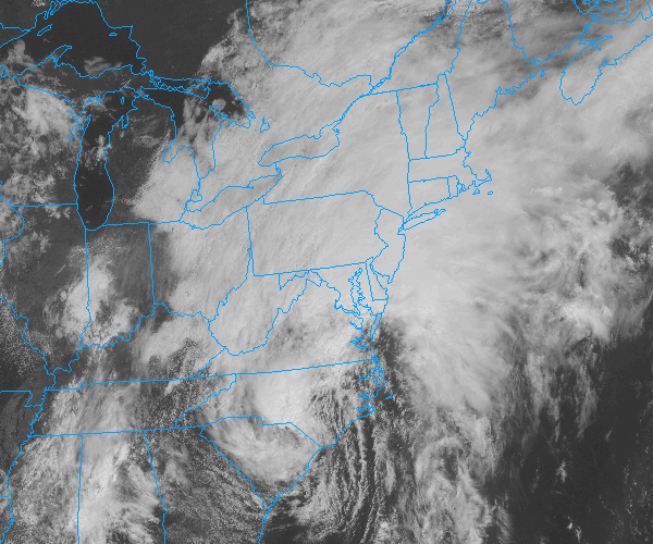
Unsettled weather has gripped the areas weather pattern once again, after the remnants of Tropical Storm Andrea provided the area with 4-5 inches of rainfall. Multiple perturbations and individual disturbances will move through the Northeast US over the next several days, providing the chance for unsettled weather essentially throughout the week. After a prolonged period of clouds and showers on Monday, some clearing is expected on Tuesday with temperatures warming into the upper 70’s to near 80. By the afternoon, however, scattered showers and storms will return to the forecast. There could be a break in the action by midweek (Wednesday most likely), before chances of more steady rain return by Thursday and Friday.

Visible satellite imagery from the afternoon of June 10th, 2013 showing clouds and unsettled weather throughout the Northeast US.

Rest of Today (Monday): Cloudy with showers. Rain could be heavy at times. Highs in the lower 70’s. East winds around 10 miles per hour. Chance of precipitation 100%.

Monday Night: Cloudy with showers likely. Some thunder is also possible. Low temperatures falling into the mid 60’s. Southeast winds around 10 miles per hour. Chance of precipitation 100%.

Tuesday: Partly cloudy early and warmer with highs in the upper 70’s to lower 80’s. Showers and thunderstorms developing by afternoon. West winds around 10 miles per hour. Chance of precipitation 60%.

A look ahead: A break in the unsettled weather is possible around the middle of the week (Wednesday). But as another disturbance moves towards the Northeast/Mid Atlantic states by Thursday and Friday — the likelihood of showers and storms will increase once again. Behind this disturbance, early indications are that next weekend will feature dry but cooler than normal conditions.

Tropical rains continue, messy PM commute likely

[alert type=”error”]Flash Flood Watch in effect through Saturday | Hazardous Weather Briefing for T.S Andrea is now available. [/alert]

Tropical Storm Andrea, which still had maximum sustained winds of 40 miles per hour and was located over South Carolina as of 11am, was bringing widespread tropical moisture and rainfall to much of the East Coast early this afternoon. As she continues to move north and east (and eventually become post tropical) the center of the low pressure will pass off the Mid-Atlantic coast and then over or near Cape Cod on Saturday. To the northwest of the surface low, heavy tropical rains are expected — which places our area in a high probability for a prolonged heavy rain event.

Tropical Storm Andrea, as seen on visible satellite June 7th, 2013. Andrea was moving northeast and continued to pack maximum sustained winds of 40 miles per hour.

Tropical Storm Andrea, as seen on visible satellite June 7th, 2013. Andrea was moving northeast and continued to pack maximum sustained winds of 40 miles per hour.

Through Tonight: Heavy rain likely, especially after 2pm. A thunderstorm is also possible. Temperatures topping out in the upper 60’s this afternoon, but only falling into the low 60’s overnight. East winds around 15 miles per hour. A washout — bring an umbrella and a rain coat if you have to head out.

Friday PM commute will be a messy one: With a few inches of rain already recorded in the area, and the heaviest rain expected to begin around the evening commute on Friday, you can expect delays (some major) on roads that do not handle the rain well. Flooding is expected on low lying roads and poor drainage roads. Drive carefully in the heavy rain as well, as visibilities will be reduced especially on highways.

Looking ahead: The forecast remains wet through Saturday morning, but some clearing is possible by Saturday afternoon as the system moves out of the area fairly rapidly. Showers and maybe a thunderstorm are still possible through Saturday evening. Sunday looks to be the winner of the weekend, with highs in the upper 70’s to low 80’s and partly cloudy skies.

Increasing clouds, tropical rains late week

[alert type=”error”]Hazardous Weather Briefing for T.S Andrea is now available. [/alert]

Tropical Storm Andrea formed last night in the Eastern Gulf of Mexico, and has strengthened into a system with maximum sustained winds of 60 miles per hour. Andrea is forecast to head northward, making landfall on the Florida Gulf Coast later today. More importantly for our area, she will then scoot north and east to a point off the Mid-Atlantic Coast late Friday Night into early Saturday morning. As she is absorbed into a mid level trough which will be scooting across the Ohio Valley, the surface low pressure associated with Andrea will likely feature the potential for heavy tropical rains on the west side of it.

After a good start to Thursday, we are expecting the potential for rain to increase — with mid and high clouds building into the area. Friday and Saturday could both feature periods of heavy tropical rains, with plenty of moisture and humidity and the potential for some thunderstorms as well.

Thursday: Partly cloudy early, becoming mostly cloudy late. Highs in the lower 70’s. Southeast wind around 10 miles per hour. E njoy the sun while you can!

Thursday Night: Cloudy with rain likely, becoming heavy at times late. Lows near 60. East wind around 10 to 15 miles per hour. Bring a rain coat, but you won’t be too chilly — the humidity will increase.

Friday: Heavy rain likely, with a high near 71. East winds around 10 miles per hour. A washout of a day for sure . Bring an umbrella and a rain coat — it will be a soaker.

Read more

PM Update: Pleasant evening, clouds on the increase

A gorgeous Wednesday is wrapping up throughout the NYC Area with temperatures in the middle 70’s and light southerly winds — a true gem of a day which featured low humidity and enjoyable conditions for early June. The pleasant weather is on the way out by later this week, however, with clouds increasing on Thursday and chances for rain increasing as well. Periods of steady rain are possible with tropical moisture surging into the area this weekend.

Rest of Tonight: Pleasant evening, with temperatures in the middle 70’s, falling into the upper 50’s. A bit cooler, as usual, near the shore and in the suburbs. Clouds could increase by later in the overnight period towards early morning.

Thursday: Partly to mostly cloudy in the morning with some breaks in the clouds during the afternoon. The showers should hold off until late — so it appears that Thursday could be salvaged. Highs in the lower 70’s throughout the area with a southeast breeze. It will be a little cooler near the shore.

Tropical Storm Andrea forms, remnants likely to impact the area: NWS Recon planes found Tropical Storm force winds and a closed center in a tropical entity in the Gulf of Mexico this evening — and will begin issuing advisories on Tropical Storm Andrea tonight. More importantly for our area, the tropical system will be scooped up by a progressive trough over the Ohio Valley late this week.

Forecast models are in good agreement on the fact that a surface low will eventually make its way up the east coast — with periods of heavy rain likely near and to the west of the surface low. The exact track of the surface low remains somewhat uncertain, and will determine where the heaviest rain falls. Regardless, it looks like a cloudy and rainy forecast from Thursday Night through Saturday.

Cicadas peaking in the suburbs: Just three weeks after they first appeared, the 17 year Brood II Magiciadas are causing a dramatic ruckus in the suburbs of NYC including New Jersey, Southeast NY and Connecticut. Many areas in Northeast NJ (specifically Union. Morris and Essex counties) have reported millions per square mile. The sound of the cicadas mating call is one of the loudest sounds in nature.

The cicadas will make a ton of noise over the next few days — but after mating will begin to die off as quickly as they came. After the females lay eggs in the branches, the cicadas will die off completely. The nymphs will hatch from the branches later this summer, and drop to the ground. Soon after they will bury underground, and won’t be seen again for another 17 years.

GOES 13 will return tomorrow: The “broken” weather satellite GOES-13 is expected to return to service on June 6th, 2013. The satellite has been out of service since May 22nd, 2013 after suffering from an unknown disturbance. Our friends at Climate Central have all the details.