After the first snowfall of the season on Tuesday, low temperatures fell into the single digits and teens throughout the area by early Wednesday morning. The arctic airmass settling into the area on Wednesday will stick around through the second half of the week, bringing high temperatures down into the upper 20’s and lower 30’s on Thursday. Although there won’t be any harsh biting winds, the snowpack over the interior will make it feel especially cold and will help with radiational cooling during the overnight hours. 850mb temperatures will fall to near -20 C on Thursday afternoon, and temperatures in the teens should be common each morning towards the end of this week.
The calm weather pattern will come as a bit of relief after several days of active weather with a front near the area. Owing to a dominant high pressure over the Northeast US, plenty of sun is likely on each day as we roll towards the weekend. But by the forthcoming weekend, intrigue will again increase as another mid and upper level disturbance tracks from the Central United States towards the Northeast and Mid Atlantic. As a result of this disturbance, a low pressure system is forecast to initially track towards the Ohio Valley. Eventually, a secondary low pressure will redevelop to the east, forced to do so by a strong high pressure to the north and cold air holding firm over New England. The devil is in the details with this system, as the uncertainties suggest potential for a winter weather event, but incredibly low confidence.
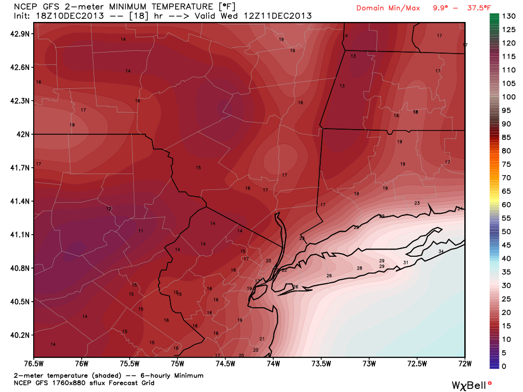
NAM model showing low temperatures in the teens on Friday morning.
https://www.nymetroweather.com/wp-content/uploads/2024/02/Empire-2000-x-300-px-2.png00John Homenukhttps://www.nymetroweather.com/wp-content/uploads/2024/02/Empire-2000-x-300-px-2.pngJohn Homenuk2013-12-11 11:42:272013-12-11 11:42:27Cold, dry weather through weeks end
The first snowstorm of the year blanketed much of New Jersey and New York with a few inches of snow on Tuesday, leaving a wintry scene behind. Forecast snowfall totals were fairly accurate — with the general 2-4″ forecast throughout the area serving as a good indicator of what was to come. A brief burst of heavy snow early on Tuesday morning began the event which continued until the middle of the afternoon, before wrapping up as scattered snow showers. Some notable snowfall reports (still preliminary) include: Newark (2.2″), Kennedy Airport (2.0″), and Central Park (1.3″), all daily records for their locations.
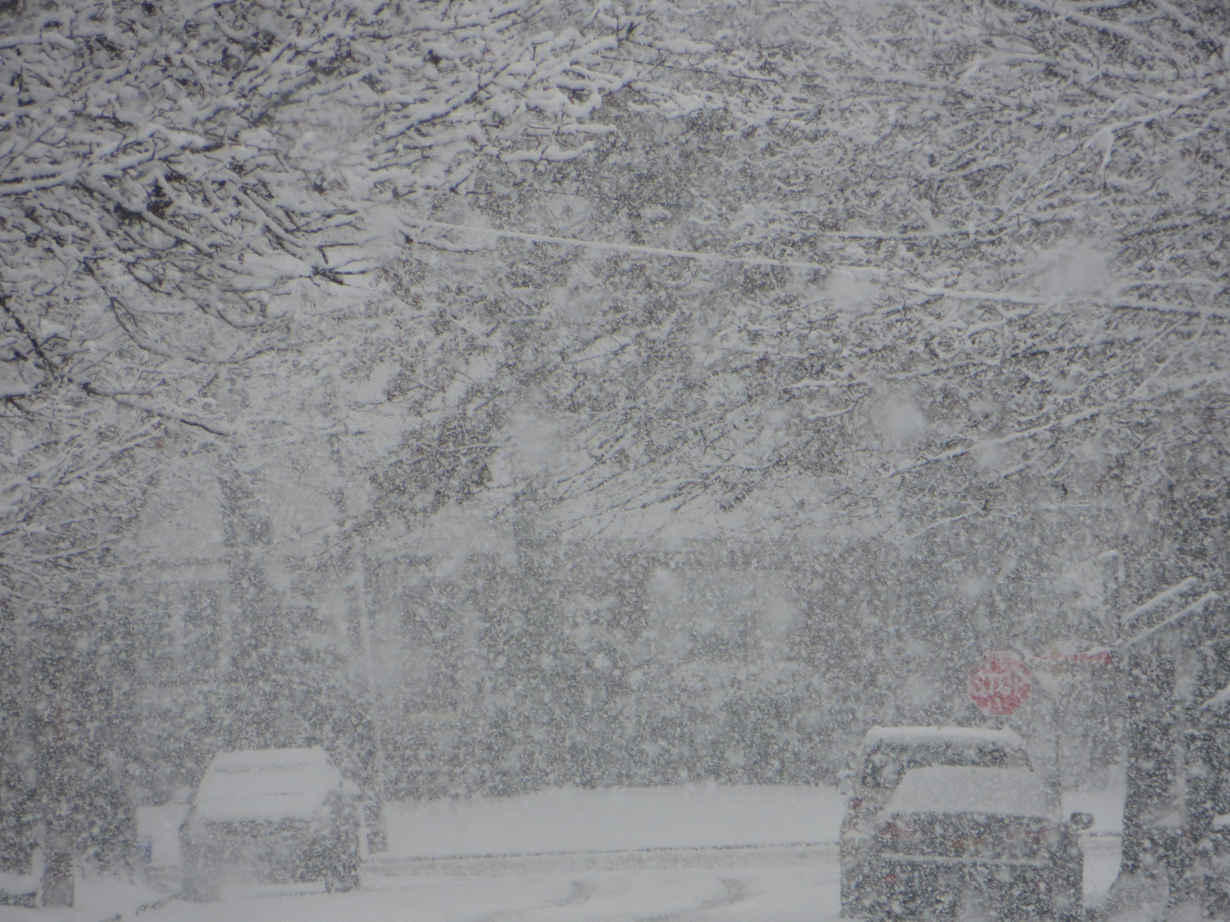
A photo taken by Doug Simonian during the heavy snow burst at 10:30am in Rockville Centre, NY.
We will post a separate article sometime tonight or tomorrow recapping the event which will have final snowfall totals, a photo gallery, and a brief analysis as far as what went right and wrong with the forecast. Although for the most part, the snowfall forecast verified, a few spots did not receive as much snow as they could have, due to surface temperatures hovering between 32 and 34 degrees, rather than in the upper 20s to around 30.
Tonight, as the storm system exits stage right, some serious cold air will begin to funnel into the area. Temperatures, both aloft and at the surface, will respond to this changing airmass and arctic intrusion — and the snow cover will help low temperatures plummet tonight. Overnight lows will fall into the teens across much of the interior and real-feel temperatures will fall into the teens in the city as well. Be aware of black ice potential on area roads, as any standing water may quickly freeze over. Wednesday morning will certainly be a shock to the system, and will feel quite wintry!
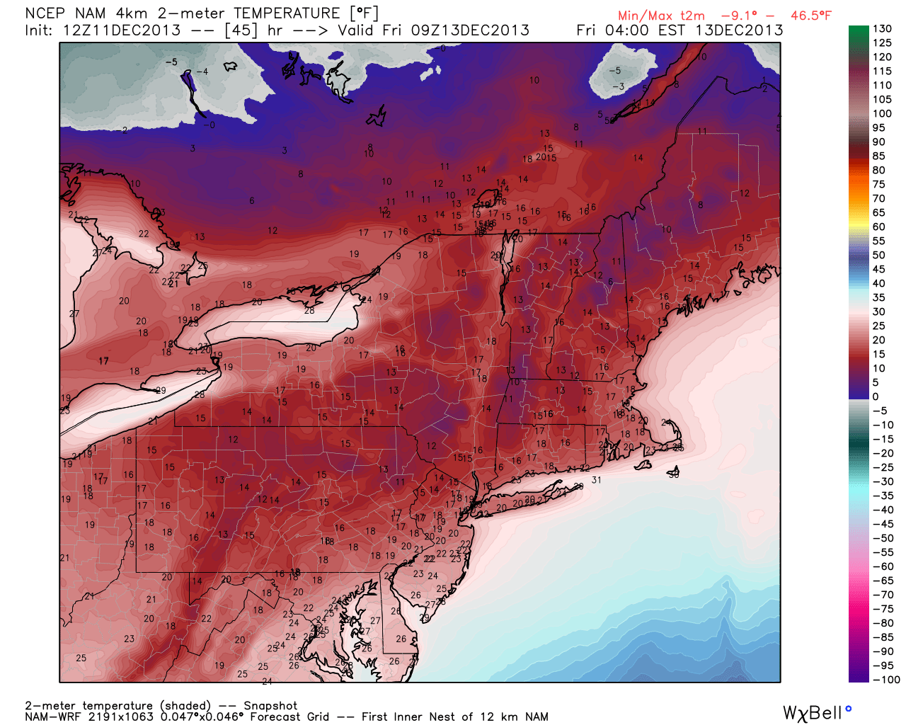
Today’s 18z GFS valid for tomorrow morning shows low temperatures primarily falling in the teens in the interior, and low 20s in the city. Temperatures on Long Island will be a bit colder than what this model is showing — probably in the low 20s as well. Image credit goes to weatherbell.com.
11:30am Update: There is a bit of a lull right now as the initial band has moved to our east, and lots of precipitation as expected missed us offshore.
But now that the system is interacting with a mid-level disturbance to our west, snow has blossomed again in E PA, and especially in SW Jersey near Philly, and head NE. The core of that heavy band may just miss NYC, but the NYC area will still see some more moderate snow within the hour and perhaps another inch or so of accumulation.
That band will probably head from I-95 and just south and east, hitting most of Middlesex county, probably clip Union county, hit Monmouth county, and then head towards Long Island, where probably another 1-2″ will fall.
There has been some melting during the lull in the action, as surface temperatures have been hovering right around freezing, and rose just above freezing during the lull in some spots. -DS
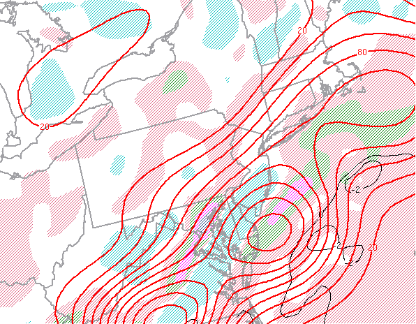
10:00am Update: Ingredients continue to lineup for heavy bands of snow in the region, particularly around the I-95 corridor or just south of it.
SPC mesoanalysis shows favorable ingredients for snowfall banding located on the I-95 corridor, or just south of it.
The image above shows a mesoscale snowfall banding parameter called EPVg. We won’t get overly technical, but it’s basically an index that tells us if we can expect slantwise convection, which is a much stronger type of lifting mechanism for snow bands than just straight convection. The values are more impressive as one heads southeastward, so lots of precipitation will blossom in S NJ and head just offshore, but there is certainly enough of this for heavy bands to traverse I-95, and especially southeast of there, particularly from 10:00am through noon. 1-2″ of snow per-hour can be expected in some of these bands, with around 1/2″ of snow per hour outside of the bands.
The storm is moving quite quickly, so even in the heaviest banding, 6″ will probably not be exceeded. A general 3-5″ snowfall is still expected, with maybe a tad less further NW of I-95 — though even there, slightly higher snow to liquid ratios due to colder temperatures may make up for the lack of precipitation. -DS
9:10am Update: Took this photo about 10 minutes ago in Rockville Centre, NY — shows that even along the coast, the roads became white right away. Be safe out there! -DS
9:00am Update: Heaviest band of snow has formed in a SW to NE zone from Trenton, through Middlesex, NW Monmouth, Staten Island, NYC, and western Long Island, where 1-2″ of snow per hour can be expected. The ideal snow growth on the models has been realized, as large, fluffy dendrites are falling.
I’m in SW Nassau County, and even here, temperatures quickly fell once the snow started, and it is now accumulating everywhere. Do not let the initial slightly above freezing temperatures fool you if you are along the coast — temperatures fall very quickly once the heavy snow arrives.
Give yourself some extra time on this morning commute. -DS
8:50am Update: Banding and areas of heavy snow have continued to develop and expand some as anticipated. A bit of warmer boundary layer (near surface) temperatures near the immediate coast will melt the initial snow (may even be a rain/snow mix) upon contact, but as snow rates increase the accumulations should begin. Not many other changes otherwise since the last update. Heavy snow is expected to continue, especially across much of New Jersey into New York City, over the next few hours.
Snowfall total forecasts also remain unchanged (you can view it in our previous article). We are expecting generally 2-5″ throughout the majority of the area (lesser end north, higher end south) with isolated higher totals in areas that sit under banding for prolonged periods of time.
Regional radar imagery as of 8:50am showing blossoming area of moderate to heavy snow throughout the area.
https://www.nymetroweather.com/wp-content/uploads/2024/02/Empire-2000-x-300-px-2.png00John Homenukhttps://www.nymetroweather.com/wp-content/uploads/2024/02/Empire-2000-x-300-px-2.pngJohn Homenuk2013-12-10 07:54:042013-12-10 11:39:47Live Blog: First winter storm of the season begins in NYC
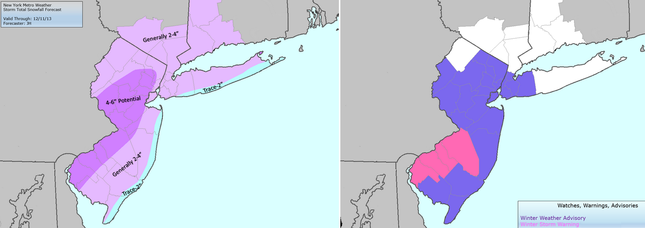
The National Weather Service issued Winter Storm Warnings and Winter Weather Advisories for the entire area on Monday evening, in advance of a light to moderate snowstorm which is expected to impact the area on Tuesday. The Winter Storm Warnings, in effect through 6pm on Tuesday evening, cover much of Southwestern and Central New Jersey as well as the major cities of Philadelphia and Trenton. Elsewhere, Winter Weather Advisories are in effect for the rest of New Jersey, New York City, Southwest Connecticut and Southeast New York. The advisories currently do not include Eastern Long Island or interior New York State.
The watches and advisories were issued in advance of a forecast snowstorm, which will approach the area on Tuesday. A mid level disturbance sliding eastward, and a frontal boundary providing the focal point for enhanced lift and development of precipitation, will set the stage for the event. A band of moderate to heavy snow is forecast to develop by late Tuesday morning, but forecast models have been struggling with the exact placement of the band. Regardless of that bands eventual position, 1-3″ of snow seems increasingly likely throughout the majority of the region. But the heavy snow band, and enhanced forcing within it, provides extra intrigue for potential higher amounts. We break down Tuesday snowfall event with timing, snowfall totals, and hazards information below.
Storm total snowfall forecast (left) and NWS Watches, Warnings and Advisories (right).
Hi friends! Our website uses cookies to provide an optimal browsing experience for you. New "Cookie Consent" laws mandate us to inform you of this. As long as you're cool with it, just hit OK. You'll only see this message once.
We may request cookies to be set on your device. We use cookies to let us know when you visit our websites, how you interact with us, to enrich your user experience, and to customize your relationship with our website.
Click on the different category headings to find out more. You can also change some of your preferences. Note that blocking some types of cookies may impact your experience on our websites and the services we are able to offer.
Essential Website Cookies
These cookies are strictly necessary to provide you with services available through our website and to use some of its features.
Because these cookies are strictly necessary to deliver the website, refusing them will have impact how our site functions. You always can block or delete cookies by changing your browser settings and force blocking all cookies on this website. But this will always prompt you to accept/refuse cookies when revisiting our site.
We fully respect if you want to refuse cookies but to avoid asking you again and again kindly allow us to store a cookie for that. You are free to opt out any time or opt in for other cookies to get a better experience. If you refuse cookies we will remove all set cookies in our domain.
We provide you with a list of stored cookies on your computer in our domain so you can check what we stored. Due to security reasons we are not able to show or modify cookies from other domains. You can check these in your browser security settings.
Other external services
We also use different external services like Google Webfonts, Google Maps, and external Video providers. Since these providers may collect personal data like your IP address we allow you to block them here. Please be aware that this might heavily reduce the functionality and appearance of our site. Changes will take effect once you reload the page.
-2")
![IMG_5441[1]](http://www.nymetroweather.com/wp-content/uploads/2013/12/IMG_54411.jpg)