The Storm Prediction Center has used the same risk categories for a large part of most of our meteorological careers. Although they have adjusted the probabilities, percentages, and yes even the colors — the categorical risk areas have remained the same. In Spring 2014, that will change. The Storm Prediction Center currently uses a simple categorical risk system which highlights the potential for severe thunderstorms across the country. The risk areas of Slight, Moderate and High are triggered by percentage chance of a type of severe weather within 25 miles of any point. And while the newer outlooks also highlight the potential for general non-severe thunderstorms across the country, Spring 2014 will mark a dramatic change in the outlooks.
The main change will be the addition of two risk levels, both falling on opposite sides of the “Slight” risk of severe thunderstorms. “Marginal”, a new risk category, will highlight the potential for severe thunderstorms that includes a 5-10″ chance of wind and hail and a 2-5% chance of tornadoes — but does not trigger a slight risk. “Enhanced” falls on the other side of “Slight”; in other words the risk levels are enhanced (30-45% risk) but not organized or widespread enough to trigger a Moderate Risk. Below, the Storm Prediction Center has released a new probability to categorical description table to help understand the changes.
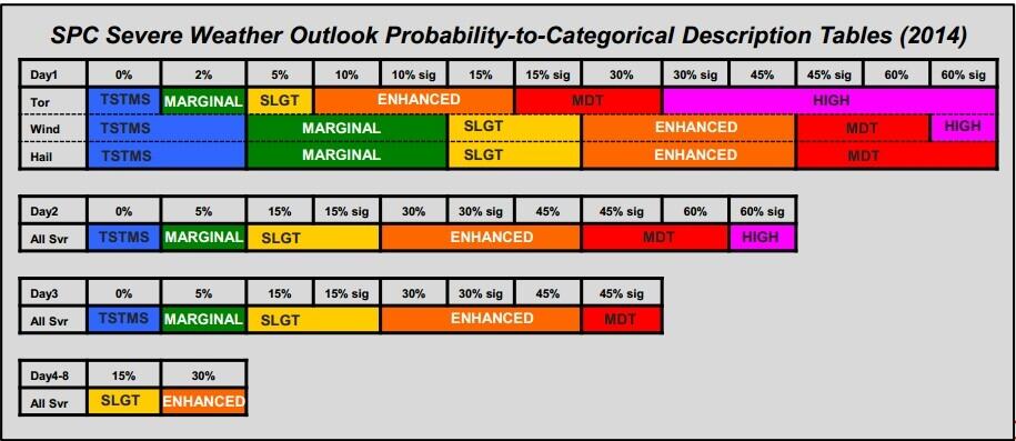
The new SPC risk categories expected to be implemented in 2014.
https://www.nymetroweather.com/wp-content/uploads/2024/02/Empire-2000-x-300-px-2.png00John Homenukhttps://www.nymetroweather.com/wp-content/uploads/2024/02/Empire-2000-x-300-px-2.pngJohn Homenuk2014-01-14 22:04:572014-01-14 22:04:57SPC set to add two new risk categories in 2014
As we are currently in the midst of a January thaw, many people are looking ahead to find out when this thaw will end and when snow chances will begin. Some rumors had been spreading about a snowfall event on Wednesday/Thursday, and again around Saturday, but both of these threats appear unlikely to produce much in the way of snow. It is not until next week and beyond when we expect the pattern to become more favorable for snow.
Taking look at the threat, or lack-there-of, for Wednesday into Thursday, the main problems stem from a progressive pattern and one that is still in flux.
Today’s 12z European model shows an unfavorable look for a snowstorm on Wednesday night with a very progressive pattern. Image credit goes to the WSI Model Lab.
The above image is the 500mb pattern and vorticity that is forecast by the European model for Wednesday night. There is a large area of vorticity in the southeast states, but notice how it is very elongated and not consolidated. Also notice how there is another disturbance right on its heels in the Northern Plains and Midwest. This leads to shortwave ridging in the Ohio and Tennessee Valley, which penetrates the trough and forces it to be very narrow and progressive. Also working against the potential for a bigger system is the lack Atlantic blocking to help the pattern to buckle. Instead, the entire country has a NW to SE axis to the heights, instead of a more meridional north to south flow. Thus, there is no room for the trough to grow and amplify. So this disturbance slides out to sea, and does not impact the area. There may not be any precipitation at all in the Wednesday night into Thursday time period.
The same general theme holds true for the threat on Saturday.
Today’s 12z European Model valid for Friday night shows a slightly improved pattern for snowfall, but still not one that ultimately supports a snow event. Image credit goes to the WSI Model Lab.
Moving forward to Friday night, we can notice a few important features. First of all, there is still a strong PNA ridge out west, which promotes a tough in the East, and could theoretically favor snowstorm chances. That being said, the Atlantic and Arctic blocking are still nowhere to be found, so the trough cannot buckle. It’s still a progressive pattern — one with a NW to SE height orientation throughout most of the country, which leaves no room for major trough amplification. We have a trough in the East, but once again, the vorticity is relatively disjointed and the trough is being pushed eastward. There is another disturbance right on its heels again in Minnesota, which forces weak shortwave ridging in Illinois, further preventing major amplification of any trough. By the time the trough is finally able to amplify and consolidate, it is already out to sea, with maybe a few passing snow showers. Eastern New England could potentially receive a couple of inches of snow, however.
https://www.nymetroweather.com/wp-content/uploads/2024/02/Empire-2000-x-300-px-2.png00Doug Simonianhttps://www.nymetroweather.com/wp-content/uploads/2024/02/Empire-2000-x-300-px-2.pngDoug Simonian2014-01-14 15:19:562014-01-14 21:06:01Chances for cold and snow are significantly increasing to close the month
It’s almost as if “roller coaster” has become an insufficient way to describe the pattern changes that our area has observed over the past several weeks. This past 5-7 day period was no different, as we transitioned from the Polar Vortex with sub-zero wind chills to a strong southerly flow and temperatures in the 60’s. After a cold frontal passage on Saturday evening, however, things have settled down a bit. Monday will end up relatively benign with temperatures slightly above average — and minimal precipitation.
The changes begin by late Monday, however, as increasingly thick clouds will begin to stream into the area from the southwest. A mid level disturbance approaching the area from the Mississippi Valley will be moving quickly off to the northeast, and minimal amplification is expected with no significant low pressure system. Nevertheless, unsettled weather with clouds and showers will grab the reigns of the forecast from Monday Night into Tuesday. Above normal temperatures will eventually be shunted east of the area once again as more wintry air moves in behind the system by midweek.
NAM model showing the development of widespread showers and clouds throughout the area late Monday Night into Tuesday.
Warm, humid air with showers and thunderstorms were the main characteristics of the airmass on Saturday — but a distinct cold front moved through the area later on Saturday evening and the airmass has changed dramatically since then. Winds shifted from southerly to west-northwesterly by late Saturday evening into Sunday morning, and temperatures in the mid levels will drop even more considerably Sunday morning. Although overnight temperatures won’ t be frigid (especially in comparison to what we were dealing with 5 days ago), highs on Sunday will only reach into the mid 40’s, considerably cooler than Saturday.
Fair weather will be the main weather story through early week, despite the potential for a few showers on Monday. Sunday looks quiet, with around average temperatures and a westerly breeze. With no precipitation or hazards expected, it will be a sufficient close to a weekend which had only featured unsettled and dreary conditions to this point.
NAM model forecasting high temperatures in the mid 40’s on Sunday afternoon.
Hi friends! Our website uses cookies to provide an optimal browsing experience for you. New "Cookie Consent" laws mandate us to inform you of this. As long as you're cool with it, just hit OK. You'll only see this message once.
We may request cookies to be set on your device. We use cookies to let us know when you visit our websites, how you interact with us, to enrich your user experience, and to customize your relationship with our website.
Click on the different category headings to find out more. You can also change some of your preferences. Note that blocking some types of cookies may impact your experience on our websites and the services we are able to offer.
Essential Website Cookies
These cookies are strictly necessary to provide you with services available through our website and to use some of its features.
Because these cookies are strictly necessary to deliver the website, refusing them will have impact how our site functions. You always can block or delete cookies by changing your browser settings and force blocking all cookies on this website. But this will always prompt you to accept/refuse cookies when revisiting our site.
We fully respect if you want to refuse cookies but to avoid asking you again and again kindly allow us to store a cookie for that. You are free to opt out any time or opt in for other cookies to get a better experience. If you refuse cookies we will remove all set cookies in our domain.
We provide you with a list of stored cookies on your computer in our domain so you can check what we stored. Due to security reasons we are not able to show or modify cookies from other domains. You can check these in your browser security settings.
Other external services
We also use different external services like Google Webfonts, Google Maps, and external Video providers. Since these providers may collect personal data like your IP address we allow you to block them here. Please be aware that this might heavily reduce the functionality and appearance of our site. Changes will take effect once you reload the page.