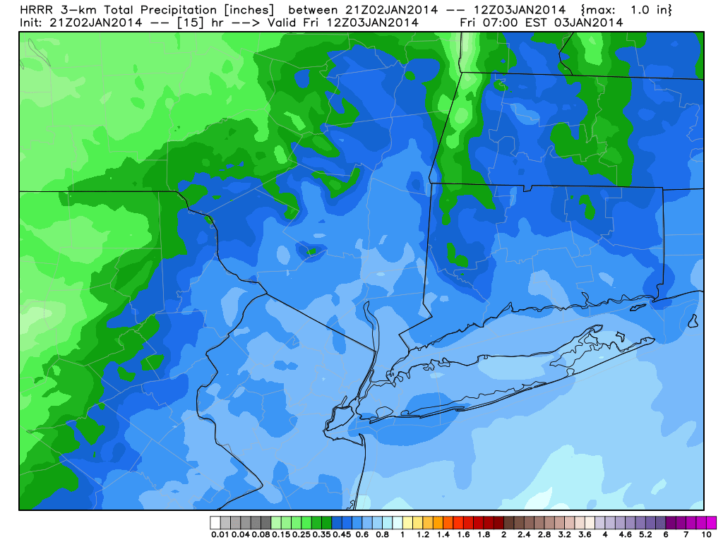
After a significant winter storm blanketed the area overnight (snowfall totals and maps forthcoming later today once we gather more data), some snow still lingered across the area early this morning. The snow was falling mainly along the New Jersey shore and Long Island as a result of an inverted trough, or an area of lower pressure and forcing which extends away from the main low pressure system. In this case, the main surface low pressure is well east of our area, but the inverted trough extending westward towards the coast is allowing for some continued precipitation.
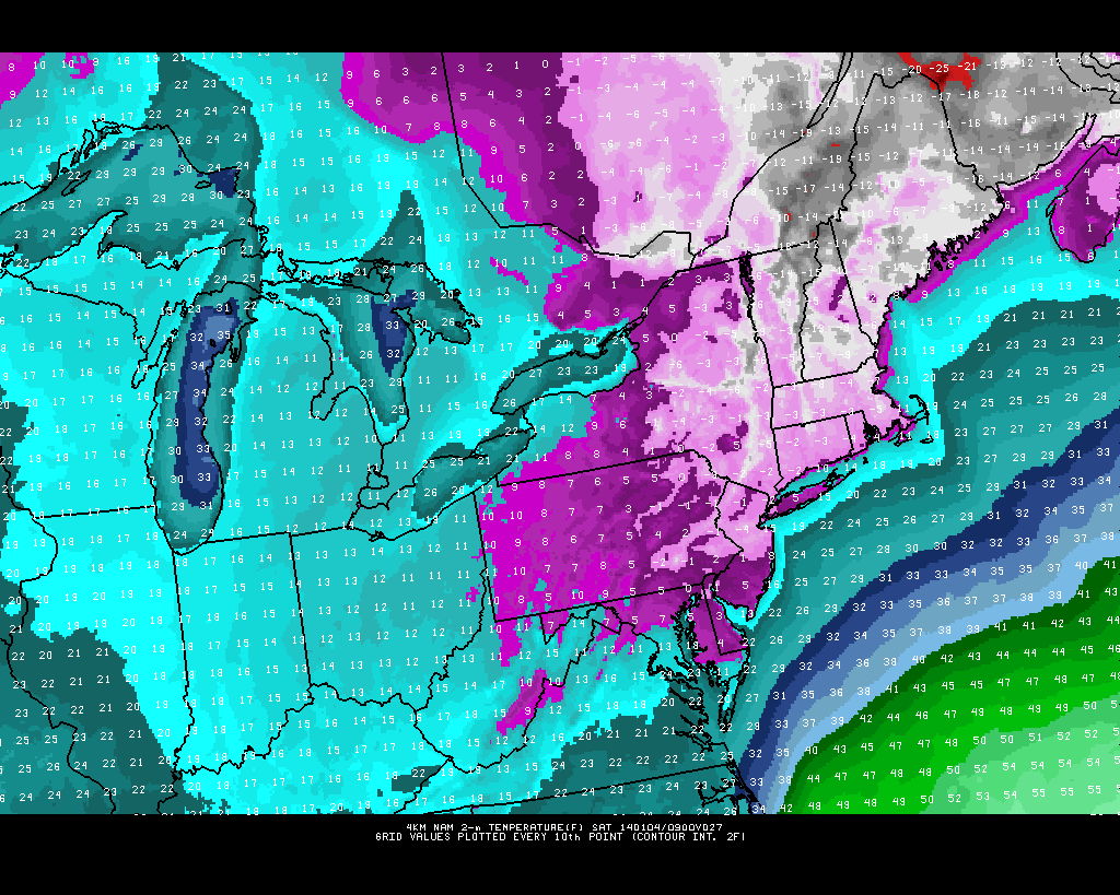
Filtered sun will give way to clearing by later this afternoon throughout much of the area as the storm system finally pulls away. But by tonight, cold air will become the dominant story. Forecast models are in good agreement on a very cold airmass and classic northerly winds settling into the area — but with the new snow pack, temperatures could take a historic tumble. Forecast guidance is indicative of low temperatures dropping below 0 F during the overnight from Friday into Saturday, putting some low temperature records in jeopardy. The air will feel even colder due to the aforementioned winds, with wind chill values well below zero through the entire area.
NAM model forecasting low temperatures below zero through much of NJ and NYC tonight.
https://www.nymetroweather.com/wp-content/uploads/2024/02/Empire-2000-x-300-px-2.png00John Homenukhttps://www.nymetroweather.com/wp-content/uploads/2024/02/Empire-2000-x-300-px-2.pngJohn Homenuk2014-01-03 09:26:342014-01-03 09:26:34Snow lingers, but cold air becomes main story
The National Weather Service issued Blizzard Warnings and Winter Storm Warnings for Long Island and New York City respectively on Wednesday, in advance of an approaching winter storm. Confidence is rising in the potential for moderate to high snow amounts, along with gusty winds and bitterly cold temperatures which are expected to follow the storm system. If you missed our Storm Overview Post, check it out for the latest information on hazards, timing and concerns. Throughout the day, we will be updating the live blog below with the latest information and imagery from our forecasters. Check back for the latest with updates every hour, or more frequently depending on the abundance of new information or the amount of hazardous weather ongoing.
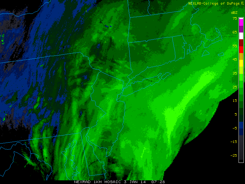
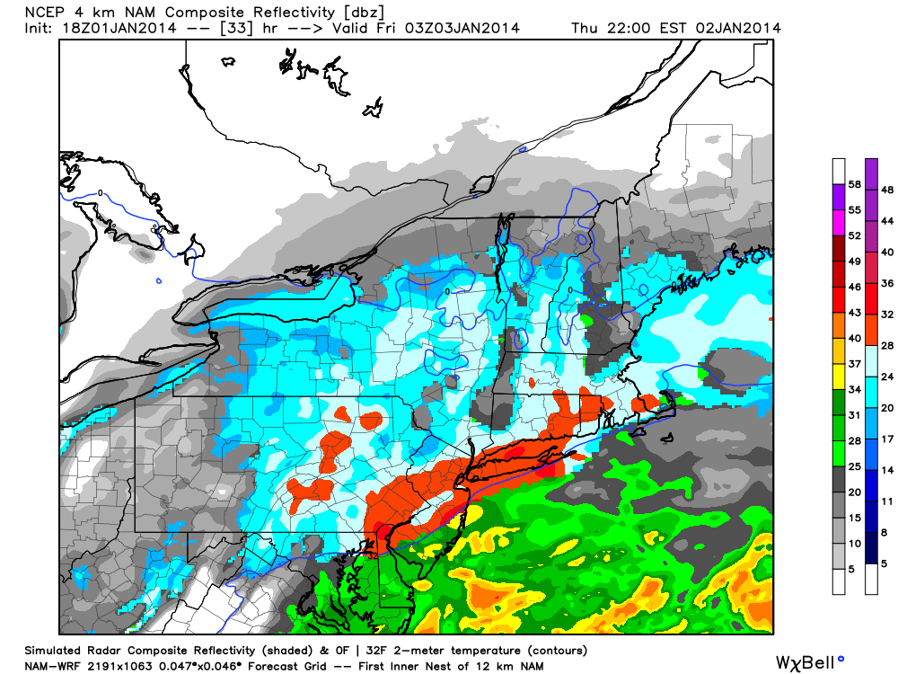
3:00am Update: The inverted trough portion of the storm continues to take shape, as moderate to at times heavy bands of snow continue to form, pivot, and back-build, prolonging the duration of the snow, bringing many locations their heaviest snow of the night. Most locations still have another 6 hours of solid snow left, which could add another 2 to as much as 5″ of additional accumulation. Current radar shows a heavier band of snow forming in SW Jersey, streaming from SW to NE all through most of NJ and into NYC, SW CT, and Long Island, which will have 1″/hour snowfall rates at times, with 1/2″ per hour rates outside of heavier banding. However, any 2″/hour precipitation rates should remain offshore.
Temperatures also continue to plummet, as NYC recorded an observation of 12 degrees, with heavy snow and 1/4 mile visiblities.
Snow has also back-built into Baltimore and D.C. again, where snow had previously ended. This is an indicator of our storm strengthening, as stronger counter-clockwise motion takes place in the presence of a deeper low pressure system. -DS
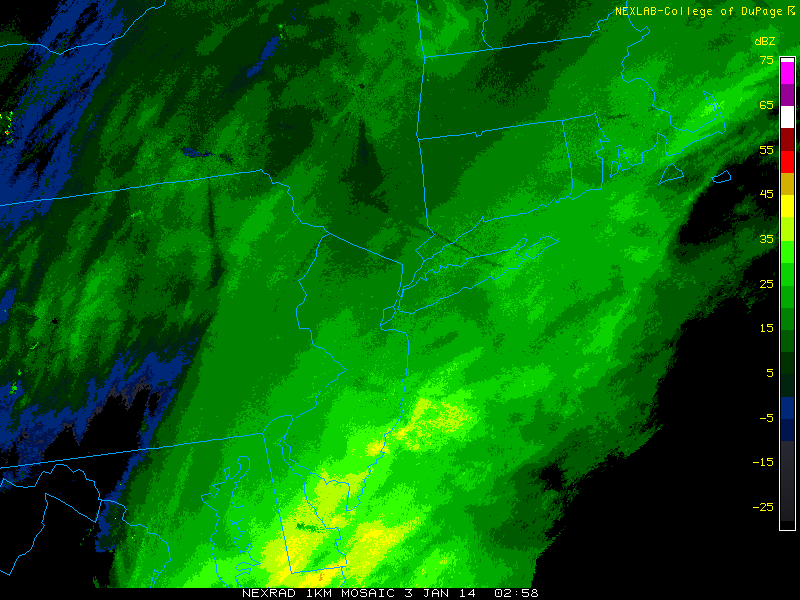
10:15pm Update: Snow is primarily light in North Jersey, light to moderate in NYC and Long Island, but moderate to at times heavy in Central and South Jersey. There was a bit of dry air that has lingered a bit longer in North Jersey — plus the fact that the storm is still a bit to the south of the area leads heavier precipitation to fall further south.
Current radar imagery shows heavier precipitation near the Delmarva. A lot of that heaviest precipitation will slide out to sea, but some moderate to heavy snow will still pivot into the area over the next several hours.
The lowest surface pressures are east of southern Virginia, so the best lifting for precipitation is naturally still to the south. However, some of that precipitation near Delaware is rain and sleet, which is why it’s more impressive on radar. Additionally, as the storm tracks northeastward, the mid and upper level trough will begin to mature and obtain a negative tilt. A negatively tilted trough is one that lines up from northwest to southeast, instead of southwest to northeast. That helps to slow down moisture advancement and gets it to pivot and blossom. The ultimate further south and east track of the surface low will prevent widespread 2″/hour snowfall rates, but steady and occasionally heavy snow of 1″/hour can still be expected at times.
Models are also signaling an inverted trough feature that will develop in association with the negatively tilted trough. This will help for light snow to linger through the early morning hours, with temperatures around 10 degrees. Although snow may be light, the snow to liquid ratios may be at least 15:1 at that point, leading to potentially another couple of inches of snow. The best chance for significant inverted trough enhancement will be in Monmouth and Ocean Counties. -DS
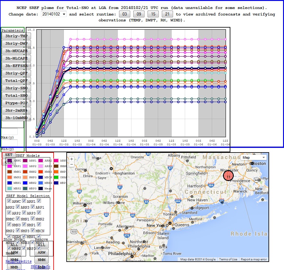
9:45pm Update: Short-term model data continues to show an increase in snowfall totals. The latest SREF plumes show a mean of 9.66″ of snow for LaGuardia Airport. Each line represents an individual SREF member, and the black line represents the mean:
Additionally, the storm continues to get organized. It has already overperformed in Washington, D.C. suburbs, where a few to several inches of snow have fallen, when little was forecast. The storm is taking on a classic comma-head shape and heavier bands of snow will pivot into the area as time goes on. Temperatures are continuing to drop as well through the lower 20s and into the teens, helping the snow become very light and powdery.
At times, radar returns may be pretty weak. However, because of how light and fine the snow is, it will not have as high of returns on radar, so snow will still come down moderately even if the radar does not seem all that impressive. -DS
6:00pm Update: New high resolution and mesoscale model data continues the theme of the forecast which we updated this afternoon. A general consensus on .5 to .75″ of liquid throughout the area, with some higher amounts farther to the east. Snow is overspreading the region at this hour and will become steady through 8pm. Accumulations are expected to begin rather quickly, and roads will become slick and snowy. Heavy snow is then forecast to overspread the area tonight. Our forecast for 7-10″ throughout the area remains the same, with some local variations possible.
Falling temperatures, gusty winds, and steady snow will create very hazardous driving and traveling conditions tonight. We strongly discourage traveling unless completely necessary.
New Jersey and New York have declared states of emergency through Friday and all New Jersey government offices are closed. In addition, there are several major road closures expected including the NY State Thruway south of Albany and the Long Island Expressway from Queens to Riverdale. -JH
HRRR model forecasting total precipitation amounts of 0.7 to 0.8″, which equates roughly to 8-10″ of snow based on ratios.
Forecast models have come into better agreement on a more organized snowstorm impacting the region primarily from tomorrow evening through Friday morning. Uncertainties still remain regarding specific details and whether the storm will track closer to the coast than modeled, but we have laid out some of the essential details in a public overview below.
Potential Hazards: Significant snow, with a general 6-10″ of snow expected across the region. There is the potential for snowfall amounts of 12″ or higher in the Hudson Valley, southern CT, and eastern Long Island. The cold temperatures will lead to a powdery snow, and combined with northerly winds around 20mph with gusts to near 40mph, will lead to blizzard conditions at times, particularly closer to the coast. Roadways will become quite slick, and wind chills will be in the single digits and even below zero at times during the storm. If you are out, make sure to bundle up with several layers. Travel is likely to become very difficult at times.
NAM model showing heavy snow throughout the area on Thursday night into Friday morning.
Hi friends! Our website uses cookies to provide an optimal browsing experience for you. New "Cookie Consent" laws mandate us to inform you of this. As long as you're cool with it, just hit OK. You'll only see this message once.
We may request cookies to be set on your device. We use cookies to let us know when you visit our websites, how you interact with us, to enrich your user experience, and to customize your relationship with our website.
Click on the different category headings to find out more. You can also change some of your preferences. Note that blocking some types of cookies may impact your experience on our websites and the services we are able to offer.
Essential Website Cookies
These cookies are strictly necessary to provide you with services available through our website and to use some of its features.
Because these cookies are strictly necessary to deliver the website, refusing them will have impact how our site functions. You always can block or delete cookies by changing your browser settings and force blocking all cookies on this website. But this will always prompt you to accept/refuse cookies when revisiting our site.
We fully respect if you want to refuse cookies but to avoid asking you again and again kindly allow us to store a cookie for that. You are free to opt out any time or opt in for other cookies to get a better experience. If you refuse cookies we will remove all set cookies in our domain.
We provide you with a list of stored cookies on your computer in our domain so you can check what we stored. Due to security reasons we are not able to show or modify cookies from other domains. You can check these in your browser security settings.
Other external services
We also use different external services like Google Webfonts, Google Maps, and external Video providers. Since these providers may collect personal data like your IP address we allow you to block them here. Please be aware that this might heavily reduce the functionality and appearance of our site. Changes will take effect once you reload the page.
-2")