It was a wonderful Saturday. High temperatures in the 50’s, plenty of sun and no precipitation to speak of. The first “winner” of a day in several weeks, in fact. The unfortunate news is that it won’t last long, and in fact the weather from Saturday will become a distant memory by the middle of the upcoming work week. The winter pattern, which dominated for the last month or two, will return — and remain relatively relentless.
Colder temperatures will begin filtering into the area by Sunday, as a frontal boundary nears the area. All won’t be lost, still, as high temperatures will reach back into the 40’s and 50’s just ahead of the front. But as the front nears, temperatures will begin to drop — and winds turn to a much cooler direction. By late Sunday Night into Monday, forecast models are in agreement that light precipitation will begin to develop just behind the cold front, beginning as rain and likely ending as snow in some locations away from the coast.
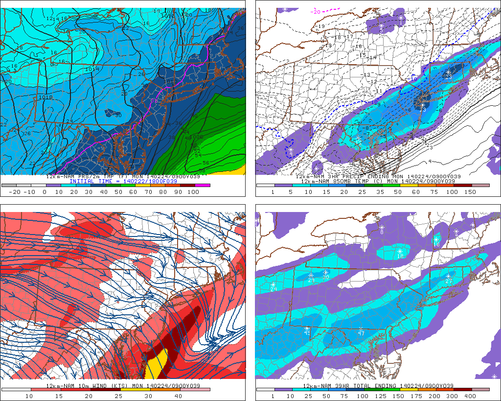
NAM model forecasting precipitation along a frontal boundary on Monday morning.
https://www.nymetroweather.com/wp-content/uploads/2024/02/Empire-2000-x-300-px-2.png00John Homenukhttps://www.nymetroweather.com/wp-content/uploads/2024/02/Empire-2000-x-300-px-2.pngJohn Homenuk2014-02-22 17:11:252014-02-22 17:11:25Colder, more wintry weather set to return
A relentlessly active pattern continues as we make our way into the latter half of February. Despite warmer air moving into the area on Thursday and Friday, a significant storm system in the Central United States will move northeastward towards the Great Lakes and drag a cold front through the area later on Friday. The weather on Thursday, in sensible terms, will be much milder than usual with temperatures both aloft and at the surface increasing and plenty of sun expected. We’ll consider it a bit of a consolation prize for the volatility of the pattern over the last several weeks. High temperatures are expected to reach close to 50 degrees in many locations (although cooler near the shore, as usual for this time of year) which will feel almost balmy compared to what we’ve become accustomed to.
Friday, however, looks to be another active weather day in the area with multiple hazards. First and foremost, the Storm Prediction Center has placed parts of Central and Southern NJ in a Slight Risk for severe thunderstorms. As mentioned above, a cold front will move through the area later on Friday. Increased forcing/lift along this front will act as an impressive trigger for storms — and southerly flow ahead of the front will likely provide adequate instability for at least elevated thunderstorms in those areas. A very impressive mid and low level jet just above our heads provides the potential for strong winds to mix down to the surface in any thunderstorms. Although widespread strong/damaging winds aren’t expected, a few severe gusts seem likely but will remain isolated. The threat drops off farther north where instability is less, although rumbles of thunder and heavy rain are still likely along the front.
https://www.nymetroweather.com/wp-content/uploads/2024/02/Empire-2000-x-300-px-2.png00John Homenukhttps://www.nymetroweather.com/wp-content/uploads/2024/02/Empire-2000-x-300-px-2.pngJohn Homenuk2014-02-20 09:22:522014-02-20 09:23:16Milder air will give way to rain, storm threat
The transient relaxation in the energizer bunny winter of 2013-14 is occurring this week, with temperatures liable to soar through the 40s and possibly 50s for Friday. However, like all warm periods this winter, we have been able to see the beginning of the next cold outbreak as the warmth moves in. And so the coming 10 day period is a microcosm of our winter’s progression to date, one which featured strong polar/arctic outbreaks interspersed with sharp yet temporary spells of mild weather.
The reload is actually occurring during the thaw, as global indicators once again resume their base state of the winter. Those who were hoping for the current shot of warmer temps to carry over into spring will be disappointed, but don’t fret, spring will come eventually (the question is when exactly). Since November, the EPO has been strongly negative, and we’ve seen the results of that with a powerful Alaskan block which effectively shuts-off the Pacific-maritime flow into the CONUS. As discussed from earlier in the season, the negative EPO would provide the impetus for driving Siberian air into North America regardless of the magnitude of blocking (lack thereof) on the Atlantic side. We’ve clearly seen how the EPO has been able to dominate the pattern even with a +NAO, much like we saw in 1993-94, 2008-09, and 1983-84, a few of the main analog years for this winter.
Going forward, there is strong model consensus on a tanking EPO by February 25th. Every time we’ve seen a significant dip in EPO values to -2 to -3 standard deviations or greater, an arctic outbreak ensues for the USA. This case will be no different. Over the next 5 days during our thaw, the mid level ridge in the north pacific will burgeon northeastward into the NW Territories of Canada, building atmospheric pressure there, and initiating the process of seeding southern Canada with bitterly cold air. That air is poised to enter the CONUS this weekend, and by early next week, will encompass the entire northern USA. That arctic air will set the stage for potential short waves to eject and attack the airmass (by mid to late next week).
https://www.nymetroweather.com/wp-content/uploads/2024/02/Empire-2000-x-300-px-2.png00Tom Stavolahttps://www.nymetroweather.com/wp-content/uploads/2024/02/Empire-2000-x-300-px-2.pngTom Stavola2014-02-19 19:57:112014-02-20 09:04:06Active Pattern To Reload For Late February and Continue Into March…
Sounds dramatic. The response to the title of this article, from some, will likely be: “Well, obviously.” But when you take a second to consider that we actually did live through one of the snowiest periods in the history of observed weather at New York City, it becomes fairly remarkable. The past 30 days or so have been nothing short of anomalous, with colder than normal temperatures (including a visit from an unusually impressive Polar Vortex) and well above normal snowfall throughout a vast majority of the forecast area.
The statistics don’t only confirm what we’ve known all along, they bring to the surface the reality of just how impressive the past month or so has actually been. The entire winter, in a certain sense, has been a giant anomaly — and it has been relentless. Things came to a bit of a head over the last 30 days, however, and our stats will focus on just how impressive the past month or so has actually been.
Snowfall by season in NYC, including 2013-2014 to date. Image courtesy Yehuda Hyman.
https://www.nymetroweather.com/wp-content/uploads/2024/02/Empire-2000-x-300-px-2.png00John Homenukhttps://www.nymetroweather.com/wp-content/uploads/2024/02/Empire-2000-x-300-px-2.pngJohn Homenuk2014-02-19 06:59:192014-02-19 06:59:39You just lived through one of the snowiest periods in NYC’s history
Hi friends! Our website uses cookies to provide an optimal browsing experience for you. New "Cookie Consent" laws mandate us to inform you of this. As long as you're cool with it, just hit OK. You'll only see this message once.
We may request cookies to be set on your device. We use cookies to let us know when you visit our websites, how you interact with us, to enrich your user experience, and to customize your relationship with our website.
Click on the different category headings to find out more. You can also change some of your preferences. Note that blocking some types of cookies may impact your experience on our websites and the services we are able to offer.
Essential Website Cookies
These cookies are strictly necessary to provide you with services available through our website and to use some of its features.
Because these cookies are strictly necessary to deliver the website, refusing them will have impact how our site functions. You always can block or delete cookies by changing your browser settings and force blocking all cookies on this website. But this will always prompt you to accept/refuse cookies when revisiting our site.
We fully respect if you want to refuse cookies but to avoid asking you again and again kindly allow us to store a cookie for that. You are free to opt out any time or opt in for other cookies to get a better experience. If you refuse cookies we will remove all set cookies in our domain.
We provide you with a list of stored cookies on your computer in our domain so you can check what we stored. Due to security reasons we are not able to show or modify cookies from other domains. You can check these in your browser security settings.
Other external services
We also use different external services like Google Webfonts, Google Maps, and external Video providers. Since these providers may collect personal data like your IP address we allow you to block them here. Please be aware that this might heavily reduce the functionality and appearance of our site. Changes will take effect once you reload the page.