Calm weather has settled into the area during the middle part of this week in the wake of a cold front, but gusty winds have ramped up over the last 12 to 24 hours with a tightening pressure gradient over the area. Blustery northwest winds led in a surface high pressure on Wednesday Night, as a low pressure system deepened well off to our north and east. The northwest winds and very low humidity are leading to concern for brush fire spread throughout the area. Subsequently, the National Weather Service has issued a Red Flag Warning for much of the area — save for Long Island, where higher humidity values are present near the coasts.
A Red Flag Warning is issued by the National Weather Service when high winds and low humidity are expected to make conditions favorable for dangerous and rapid spread of brush fires if ignition occurs. Despite the concern for fire spread, pleasant weather will continue — albeit a bit cool of this time of year. Highs in the lower 60’s will be common on Thursday and Friday before a disturbance approaches with a period of rain expected Friday Night.
Very low dew points and gusty winds could cause rapid fire spread today.
https://www.nymetroweather.com/wp-content/uploads/2024/02/Empire-2000-x-300-px-2.png00John Homenukhttps://www.nymetroweather.com/wp-content/uploads/2024/02/Empire-2000-x-300-px-2.pngJohn Homenuk2014-04-24 09:23:012014-04-24 09:23:01Pleasant, but fire danger through Friday
Today was another one of those classic days where inland areas soared into the upper 70s, and coastal areas had trouble exceeding 60 degrees, with plenty of wind.
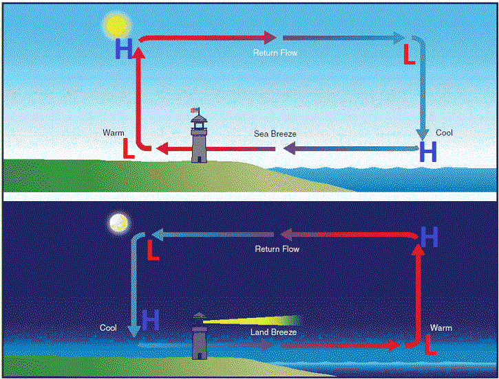
The explanation for this is the sea breeze. Whenever we have a warm, springtime airmass, the temperatures over the land warm up quickly. However, the sea is still relatively cold this time of year, especially considering how cold of a winter we had. The ocean has a high specific heat capacity, which means that it can absorb the same amount of heat as the land does, but will not warm up nearly as much as the land. Thus, during the day, the land will often be much warmer than the ocean.
The sea breeze circulation (top) and land breeze circulation (bottom). (Free Online Pilot Ground School).
Once the land heats up, thermodynamics dictate that the warm air must rise, since it is less dense. However, the relatively cold ocean does not have this same heat, as it is more dense, so the air does not rise. The rising air over the land creates a slightly lower surface pressure, since the air is escaping the surface, rather than exerting a force on it. The lack of rising air over the sea thus creates a slightly higher surface pressure, relative to the land. The atmosphere always wants to balance itself out, so to compensate for the air over the land escaping the surface, air from higher pressure has to flow towards it. This air happens to be coming from the colder ocean, which helps to create colder temperatures and windier conditions along the coast.
The circulation gets reinforced because when the air over the land rises, it creates an area of higher pressure at the upper levels of the atmosphere, since lots of air is rushing towards the upper levels. However, over the sea, there is no air rising into the upper levels, so the pressure is relatively lower there. The air with higher pressure aloft on the land thus flows towards the area with lower pressure above the sea. Now that this air is above the sea — where air at the surface is already heading towards the land — the air has to sink to replace the air that is leaving the sea. This sinking air towards the sea surface reinforces the high pressure, which reinforces the source of air that is blowing towards the land, which reinforces the sea breeze.
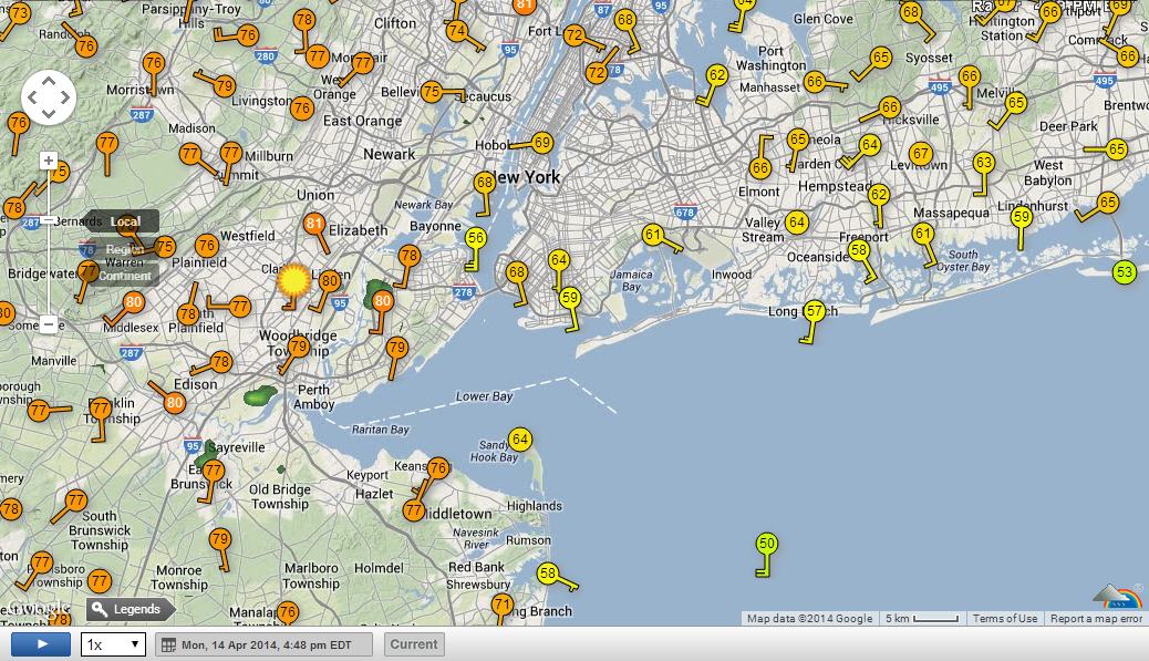
Temperature and wind observations taken from Monday (4/14/14) afternoon at 4:48pm. Notice temperatures approaching 80 in New Jersey with relatively light winds, yet much cooler and windier conditions on Long Island. Also notice how in some areas, the southerly winds are stronger on Long Island compared to areas further west (Weather Underground).
https://www.nymetroweather.com/wp-content/uploads/2024/02/Empire-2000-x-300-px-2.png00Doug Simonianhttps://www.nymetroweather.com/wp-content/uploads/2024/02/Empire-2000-x-300-px-2.pngDoug Simonian2014-04-22 16:49:512014-04-22 16:51:04The sea breeze and its cooling effect along the coast
The Storm Prediction Center has used the same risk categories for a large part of most of our meteorological careers. Although they have adjusted the probabilities, percentages, and yes even the colors — the categorical risk areas have remained the same. In Spring 2014, that will change. The Storm Prediction Center currently uses a simple categorical risk system which highlights the potential for severe thunderstorms across the country. The risk areas of Slight, Moderate and High are triggered by percentage chance of a type of severe weather within 25 miles of any point. And while the newer outlooks also highlight the potential for general non-severe thunderstorms across the country, Spring 2014 will mark a dramatic change in the outlooks.
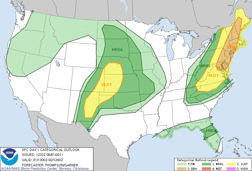
The main change will be the addition of two risk levels, both falling on opposite sides of the “Slight” risk of severe thunderstorms. “Marginal”, a new risk category, will highlight the potential for severe thunderstorms that includes a 5-10″ chance of wind and hail and a 2-5% chance of tornadoes — but does not trigger a slight risk. “Enhanced” falls on the other side of “Slight”; in other words the risk levels are enhanced (30-45% risk) but not organized or widespread enough to trigger a Moderate Risk. Below, the Storm Prediction Center has released an example of the changes in the outlooks using an example in the Northeast US from 2011. You can visualize the new outlook area with an “ENH” or Enhanced risk running throughout the majority of our forecast area. Previously, the outlooks would only show this area as “Slight”despite there being an enhanced percentage of severe weather within that slight risk.
An example of proposed changes to the Storm Prediction Center’s categorical outlook and graphics.
https://www.nymetroweather.com/wp-content/uploads/2024/02/Empire-2000-x-300-px-2.png00John Homenukhttps://www.nymetroweather.com/wp-content/uploads/2024/02/Empire-2000-x-300-px-2.pngJohn Homenuk2014-04-22 13:10:572014-04-22 13:10:57Storm Prediction Center releases details on outlook changes
After a chilly wakeup this morning, temperatures should for the most part rebound nicely across of the area, as a high pressure system remains in-place. It will keep our skies sunny throughout the day, with temperatures generally in the mid 60s. However, coastal regions will experience yet another slightly chillier day, as easterly winds off the cold ocean will prevent temperatures from exceeding 60 degrees.
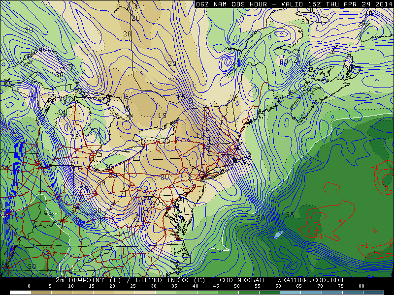
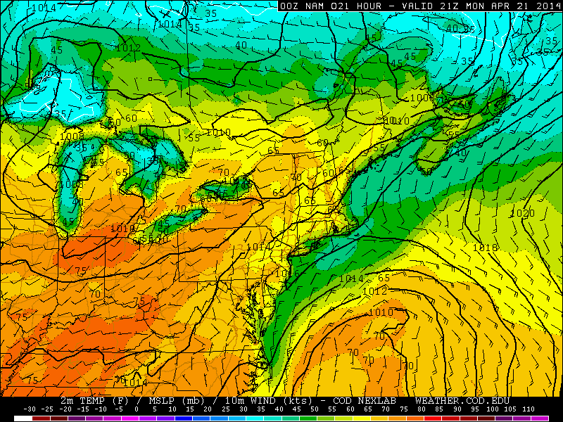
Last night’s 00z NAM model run shows temperatures well into the 60s for this afternoon in inland locations, but hovering in the 50s along the coast (weather.cod.edu).
The gradually departing high pressure system, and the low pressure system offshore are combining to generate easterly winds for this afternoon, as shown above. The pressure systems are relatively weak and are departing, which means the winds will be light — this will allow the cold, marine influence to not penetrate as far inland as they did on Easter Sunday. The lighter winds will allow temperatures to be about 5 degrees warmer than yesterday along the coast (upper 50s to around 60 as opposed to low to mid 50s), yet up to 10 degrees warmer than yesterday in areas west of the city, where temperatures in the mid 60s to upper 60s will be common. If those winds lighten up even more, we would not be at all surprised if some spots touched 70 degrees, since 850mb temperatures are a few degrees above freezing.
As that high pressure system continues to move eastward, it will give way to a low pressure system that will pass to our north on Tuesday. This will increase our high clouds a bit for Monday night, which will keep temperatures a bit warmer than they have been the past several nights.
Although most of the storm’s associated precipitation will stay to our north, it will be dragging a cold front to its south, and potentially give us some showers or even a rumble of thunder sometime late Tuesday afternoon, through Tuesday night. Read more
https://www.nymetroweather.com/wp-content/uploads/2024/02/Empire-2000-x-300-px-2.png00Doug Simonianhttps://www.nymetroweather.com/wp-content/uploads/2024/02/Empire-2000-x-300-px-2.pngDoug Simonian2014-04-21 07:00:022014-04-21 03:55:27Typical spring week in store
Hi friends! Our website uses cookies to provide an optimal browsing experience for you. New "Cookie Consent" laws mandate us to inform you of this. As long as you're cool with it, just hit OK. You'll only see this message once.
We may request cookies to be set on your device. We use cookies to let us know when you visit our websites, how you interact with us, to enrich your user experience, and to customize your relationship with our website.
Click on the different category headings to find out more. You can also change some of your preferences. Note that blocking some types of cookies may impact your experience on our websites and the services we are able to offer.
Essential Website Cookies
These cookies are strictly necessary to provide you with services available through our website and to use some of its features.
Because these cookies are strictly necessary to deliver the website, refusing them will have impact how our site functions. You always can block or delete cookies by changing your browser settings and force blocking all cookies on this website. But this will always prompt you to accept/refuse cookies when revisiting our site.
We fully respect if you want to refuse cookies but to avoid asking you again and again kindly allow us to store a cookie for that. You are free to opt out any time or opt in for other cookies to get a better experience. If you refuse cookies we will remove all set cookies in our domain.
We provide you with a list of stored cookies on your computer in our domain so you can check what we stored. Due to security reasons we are not able to show or modify cookies from other domains. You can check these in your browser security settings.
Other external services
We also use different external services like Google Webfonts, Google Maps, and external Video providers. Since these providers may collect personal data like your IP address we allow you to block them here. Please be aware that this might heavily reduce the functionality and appearance of our site. Changes will take effect once you reload the page.
-2")