-2")
Moderate to strong El Nino becoming increasingly likely
While our area has been enjoying a stretch of pleasant and warmer weather, many meteorologists and weather hobbyists alike have been analyzing interesting data in the Equatorial Pacific: signs of a developing El Nino. An El Nino is generally defined as a trimonthly period where waters in the Equatorial Pacific — from 160 Degrees East to 80 Degrees West Longitude — are warmer than normal. This tends to have effects on the general atmospheric circulation, which will be detailed in this article. The Climate Prediction Center breaks this area into four different Nino regions, since warm anomalies in different regions of the Equatorial Pacific can lead to subtle, yet important changes in how the El Nino behaves.
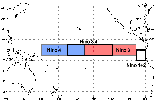
The four El Nino regions (NCDC).
The region used to officially define an El Nino event is Nino 3.4, which spans from about 170 Degrees West to 120 Degrees West. That is not to say that the other regions are not important; they are just not used in the official calculation. Let’s take a look at an example of an El Nino event:
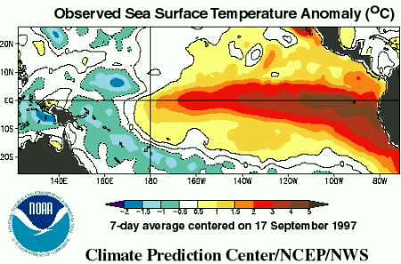
The strong El Nino event of 1997-1998. Notice how warm the waters are in the eastern Equatorial Pacific (CPC).
The El Nino of 1997-1998 was the strongest on record, as it had temperature anomalies between +2C and +5C across the eastern Equatorial Pacific. Also notice how the warmest anomalies were east of Nino region 3.4, which is a classic strong El Nino phenomenon. Let’s see how the forecast from one of our climate models compares to the 1997-1998 event.

The latest CFS model run shows an El Nino emerging (CPC).
The values on the left are anomalies in Kelvin, which can also be represented by degrees Celsius, since the incremental increases are the same for Kelvin and degrees Celsius. On the bottom, we see tri-monthly periods. The wavy black line shows what had previously been happening — generally, there was no anomaly at all, indicating no El Nino, nor its counterpart, a La Nina. However, moving forward in time, notice how all of the lines, which represent forecasting members, show a pretty fast increase in the anomaly through the coming months. Another interesting point is how the red lines are the earlier members, and the blue lines are the latest members — and there appear to be more blue members hedging towards the warmer side of the mean than the red lines — which is perhaps an indicator of a further warming trend.
The threshold for a strong El Nino is an anomaly of +1.5C or higher, which certainly seems attainable according to the CFS. While not nearly as strong as the 1997-1998 El Nino, it would certainly still be pretty strong, and the fact that the latest members look warmer than the mean indicates that the El Nino could verify warmer than the forecast mean.
Now that we know what an El Nino is, as well as how strong it is forecast to become, let’s examine what causes an El Nino, and what effects it has on our weather pattern. Read more