Period of heavy rain likely Monday, nice week ahead

The morning began in a bit of a haze — literally — as smoke from a brush fire in Southern New Jersey billowed north/northeastward toward much of New Jersey and the 5 boros of New York City. So if you’re smelling the smoke and seeing the haze this morning, in all likelihood you do not need to be alarmed. Temperatures, on the other hand, started out seasonably today in the 30’s and 40’s and will rebound a bit more into the 50’s by the afternoon hours. But an approaching storm system will end up bringing an end to any pleasant weather by this afternoon.

A low pressure system shifting through the Ohio Valley will bring a warm front and area of enhanced lift for heavy precipitation with it later today. Showers are expected to shift northward towards Southern and Central NJ by late morning, and then into Northern NJ and NYC by early to mid afternoon. If you’re headed out to the Yankees home opener this afternoon, bring an umbrella and rain gear. Although the first pitch and ceremonies likely won’t be a washout, the increasing likelihood of showers and steady rain by mid to later innings suggests things could get a little dicey in terms of potential rain delays or even postponement.

HRRR model showing heavy rain in the area this evening.

HRRR model showing heavy rain in the area this evening.

Read more

Backdoor cold front season is here, what’s the deal?

Each spring we emerge from a long cold winter with aspirations of 70 degree temperatures, a cool breeze and plenty of sun.  It rarely works out that way. Whether it be an upper level low, a stalled cold front, or a backdoor frontal boundary there are plenty of meteorological events that could be to blame for a colder and damp spring in this area. The fact of the matter is, our location during a transition season (fall, spring) is a difficult place to be. The changing and morphing wavelengths of the mid and upper level ridges and troughs mean the potential for cutoff lows, and the colder ocean waters this time of year especially will wreak havoc on any warmup.

This time around, we have a significant low pressure system moving through the Central United States. Meteorology tells us that a warm front should be surging north from the Mid Atlantic states into New England as this low pressure moves towards the Great Lakes, with southerly winds ramping up warm air south of the warm front. But where is the warm front, and why hasn’t it made progress north? The answer lies in the setup both aloft and at the surface, and it leads to the development of a backdoor front which pushed the warm air back to our south. While maybe not a classic backdoor cold front, which often sweeps out very warm air and brings low clouds and fog with it, the warm front at the end of this week is stuck well back to our south as cold, marine air is entrenched over New England.

An illustration of a backdoor cold front, showing the colder marine air moving southwest from New England.

An illustration of a backdoor cold front, showing the colder marine air moving southwest from New England.

Read more

Late week weather takes a hit with backdoor front

As clouds and showers move away from the area this afternoon, we expect some late afternoon and early evening clearing, leading to late-afternoon highs near 60 in some areas. Tomorrow, we expect to have southerly winds ahead of a strong frontal system, in association with a storm system producing severe weather in the Plains, Missouri Valley, and Tennessee Valley, where storms could become quite strong today and especially for tomorrow, with large hail and tornadoes possible.

Although we certainly will not be seeing any severe weather of that sort, the front is strong enough to induce plenty of lift for clouds well out ahead of it. Thus, despite the lack of rain forecast, a decent amount of cloud cover should prevent the area from having high temperatures exceeding 60 degrees tomorrow. Still, though, tomorrow will not be a bad day, with highs in the upper 50s and mostly cloudy skies.

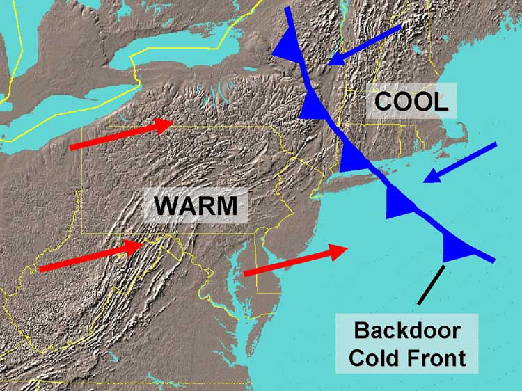
It’s Thursday night through Saturday morning that we are concerned about, with the approach of a backdoor cold front. What happens often this time of year is that when a large storm system forms well to our west, we get counterclockwise flow from that system. If you are far enough east of the low, the winds start to turn easterly (off the ocean) as opposed to southerly.

Today's 12z NAM valid for Friday afternoon shows a prominent backdoor frontal system pushing to our south, leaving us on the cold side of the boundary (NEXLAB).

Today’s 12z NAM valid for Friday afternoon shows a prominent backdoor frontal system pushing to our south, leaving us on the cold side of the boundary. Notice the cold, easterly winds pushing into our area off the Ocean, thanks to higher pressures t our north. Also notice the warmth to our south and southwest. (NEXLAB).

What also happens is that due to the strong ridging out ahead of the cold front, a high pressure system develops to our north. The clockwise flow from the high pressure to our north, which also forces easterly winds to hit our area, perhaps even more-so than the storm system did. It is the boundary where one is influenced by the high pressure to the north (cold, easterly winds) and being far enough southwest to miss this influence, but have southerly winds from the low pressure and cold front where this backdoor cold front develops.

This time of year, backdoor cold fronts are often strong, happen frequently, and push relatively far south (south of us) because the Ocean temperatures in early-spring are still quite cold, especially given the cold winter we have had. Additionally, early-spring also sees more warmth to our southwest, which makes these boundaries stronger.

Because of this front, temperatures should drop into the low 40s on Thursday night and Friday, with plenty of clouds and potentially some rain around. The higher pressures to the north may put a lid on more organized lifting in the atmosphere, so heavy rain is not initially expected, but the boundary will be enough to trigger some showers.

On Friday night and Saturday morning, the cold front to the west will eventually push through, potentially leading to a brief period of moderate to heavy rain, before gradually clearing during the day on Saturday. Although we will be on the cold side of the cold front, the high pressure to the north getting pushed away will help lessen the colder marine influence, and temperatures should not be too cool this weekend — highs in the upper 50s can be expected on both Saturday and Sunday.

However, another storm system with chilly and unsettled weather can be expected early next week. Unfortunately, sustained spring-like warmth is not in the cards anytime soon.

April off to a wonderful start with warming trend

Maybe it’s best that we just forget about March as a whole. The only people who would’ve enjoyed March 2014 are those who enjoy cold temperatures and no snow — a rare breed — and so most were lift disappointed and chilly. Spring got off to a slow start, with temperatures running 4 to 6 degrees below average during the month of March. And there was almost no snow to speak of in New York City despite multiple chances for accumulating snowfall. April, on the contrary, will get off to a great start. Temperatures in the mid 50’s to near 60 on Tuesday will mark the beginning of a warming trend which will continue into the middle of the work week.

High temperatures by Wednesday should eclipse the lower 60’s in many locations, as westerly winds and warming mid level temperatures with full sunshine allow for the warm air currently over the Tennessee and Ohio Valleys to advect eastward. Par for the course this time of year, things will be a bit cooler near the area beaches and shores. Despite the westerly winds, cold ocean waters make it very difficult for coastal locations to stay warm throughout the day in April. By the end of the week, the forecast gets a little bit more dicey with an approaching warm front and the potential for some backdoor-front action from New England.

HRRR model showing high temperatures exceeding 60 degrees west of NYC on Tuesday.

HRRR model showing high temperatures exceeding 60 degrees west of NYC on Tuesday.

Read more