Live Blog: Very heavy rain, thunderstorms tonight
Our live blog (below) will be updated throughout the night by our meteorologists as we track the expected heavy rain and thunderstorms. If you’re on our front page, click “read more” to view it.
-2")
Our live blog (below) will be updated throughout the night by our meteorologists as we track the expected heavy rain and thunderstorms. If you’re on our front page, click “read more” to view it.
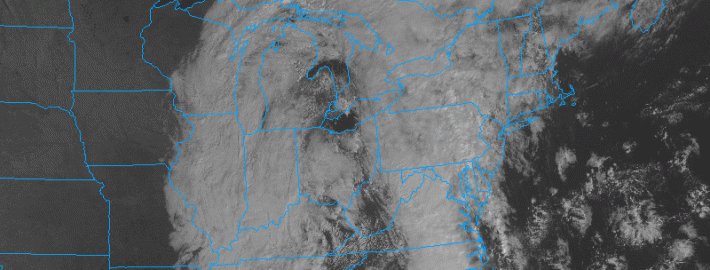
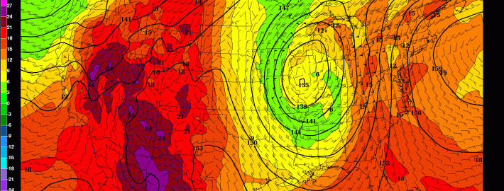
An approaching strong cold front, and associated mid and upper level disturbance, will bring heightened chances for rain into the area from tonight into Thursday morning. However, the event will be made more significant by a plume of moisture, surging northward along and ahead of the frontal boundary. Forecast models indicate a strengthening low level jet stream and transport of this moisture. Precipitable water values (the amount of water in the atmosphere) will be high — in the 95th percentile for October.
The moisture will begin surging northward later this afternoon and evening. Forecast models indicate the best lift for precipitation will remain to our west until the latter part of the afternoon. At that point, from west to east, chances for showers and thunderstorms will increase. Initially, downpours will be scattered. But over time tonight, the support for heavy rain will expand and moisture will continue surging northward. Rain will develop from southeast to northwest, with widespread heavy rain likely throughout the area overnight.
The week began with clouds and drizzle, signaling the arrival of a warmer airmass which has been pushing northward from the Southeast and Mid Atlantic states. But the dreary and drizzly weather won’t take over the forecast on Tuesday. Southerly winds will push some drier air northward, helping to lift the low clouds and fog in place throughout the area. Warmer air will settle in by Tuesday afternoon, with highs reaching the mid 70’s. This will feel noticeably warmer than the past several days, especially considering the cooler than normal air and then drizzle/foggy weather which was in place.
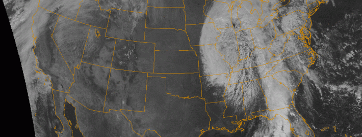
The warmer weather won’t last long. An approaching storm system, currently bringing severe weather to the Central and Southeast United States, will shift northeastward toward our area later this week. With it will come a major cold front, and a surge of moisture aiding in the development of heavy rain and thunderstorms. Although forecast models are still a bit inconsistent, the general idea is that a period of heavy rain will race through the area on Thursday. Rainfall totals of 1-2″ could be widespread, with an onshore flow providing not only hazardous marine conditions but also some coastal flooding.
The previously chilly airmass this weekend has moved out of the area and has been replaced by much warmer and humid conditions. This is in response to an area of high pressure moving out to sea, giving us southerly winds on its back side. Additionally, a storm system is developing in the Plains, which is also forcing warmer air out ahead of it. Fortunately, most of that rain should hold off until Thursday. Until then, temperatures will continue to warm well into the 70s this week.
With the abundance of southerly flow, a good amount of moisture has propelled into the area, helping to generate clouds. There is still no large-scale storm-system, so we do not expect rain the rest of today and tonight — except for a few patches of drizzle here and there. With the cloud cover, temperatures will be much warmer tonight, as they will hover around 60 degrees. A potential hazard is that patchy fog will be developing this evening and tonight, so it may be good to take some extra time for any commute tonight.