Plummeting AO could offer some winter hints

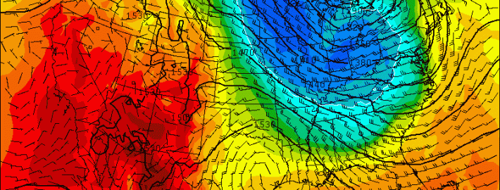
As we’ve spoken about several times already this Autumn, our winter forecast doesn’t typically come out until the first week of November. Although some will bark at us for this — we’ve been hearing it already this Autumn — there are reasons for it. Mainly, our forecasters have recognized the importance of analyzing the pattern during October and the ideas moving into November. The recognition of the pattern during the next few weeks will be immensely important to understanding how things will shake down this winter. And our first “hint” could be offered during the next several days, as the AO — or Arctic Oscillation — is forecast to take a nose-dive.

The Arctic Oscillation is a large scale monitor of climate variability, also referred to as the Northern Hemisphere Annual mode. More simply, it’s a climate pattern characterized by winds circulating counterclockwise around the Arctic — typically at around 55°N latitude. In even more simple terms — the negative phase of the AO typically displaces cold air farther south in North America, while the positive phase keeps the colder air farther north, nearer to the poles and arctic regions. Forecast models are in good agreement that the AO will nosedive over the next several days — and not surprisingly, a major shot of below-normal temperatures is expected late this weekend into early next week. 

Read more

Here comes the Autumns first big cold front

Right on cue. We spoke about this potential a few days ago when we noted the medium range forecast models suggesting the presence of high latitude ridging and blocking. These some models now agree that a significant cold front will shift from the Great Lakes and Central United States through the Northeastern United States this weekend; plowing through our area from Saturday Night into Sunday. Showers and some thunderstorms are possible with its passage, right on the periphery of a major mid and upper level trough.

The temperature different won’t really be felt on Saturday despite the fronts passage. Initially warmer air, streaming in with a southerly flow ahead of the front, will keep temperatures in the 60’s and 70’s on Saturday. After some showers and maybe an isolated storm with gusty winds, the difference will become noticeable as winds shift to west-northwesterly and much, much cooler air begins moving in aloft.

Read more

PM Update: Cloudy, damp behind backdoor front

Ah, that phrase again. Backdoor cold fronts often manifest themselves in New England and the Mid Atlantic during the transition seasons of Autumn and Spring. This year, of course, is no exception. We had plenty of them in the Spring, and this is our first of Autumn. We even wrote a detailed breakdown of how they work, and why they affect our area. Regardless, a backdoor front associated with a mid level disturbance overhead slipped past the region yesterday, and we’re feeling the full effects of it today with cloudy and damp weather.

A weak low pressure system off the coast is bringing enhanced rainfall to parts of Southern New England, Eastern Long Island and Connecticut tonight. The best forcing and lift for rain will remain to the east of the areas, but periods of more steady rain and showers are possible through tonight and into Thursday. Tonight, as a result, will remain quite cool and damp. We suggest bringing a jacket if you’re headed out. You may want to carry an umbrella along, too, just to be safe.

Read more

HRRR model goes operational at NOAA

Our forecasters have used and reference the HRRR model for a number of years now. You’ve likely seen it referenced in our posts, displayed on our graphics, and shared on our social media accounts. Our forecasters have used it for near-term forecasting, even in mesoscale events such as thunderstorms and heavy snow bands. Yesterday, NOAA finally let the HRRR out of its box with the model becoming officially operational. The model will run hourly on the NOAA server from now on, with faster graphic and product production. The model is expected to become a tremendous source of information not only for forecasters, but for hobbyists and public alike.

Known formerly as the High Resolution Rapid Refresh model, the model runs every hour and produces forecasts at 15 minute intervals, extending out to 15 hours. A tremendous amount of forecast products are produced, ranging from simulated radar to frontogenic forcing at multiple levels. The model also is a significant upgrade in resolution when compared to the more popular NAM model, and even increases resolution by four times over it’s closest companion, the Rapid Refresh (RAP) model, which had been the NOAA’s only hourly high resolution model running until yesterday.

Read more