Significant Nor’Easter becoming increasingly likely next week

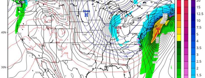
Forecast models have come into better agreement in regards to the evolution of a mid and upper level pattern during the upcoming week which will eventually lead to the development of a significant Nor’Easter on Wednesday. Although specific details, in regards to the storms track and intensity (as well as the resulting precipitation type and amounts in our area) remain uncertain, confidence is increasing fairly quickly that the significant storm will in fact develop. This means there is a high likelihood that travel will be significantly impacted by hazardous weather — on the busiest travel day(s) of the year.

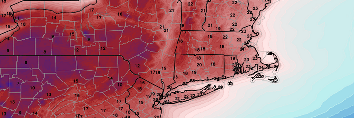
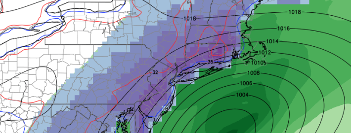
While it is too early to speak about precipitation totals, accumulations, and timing, the likelihood of the storm system impacting the area with multiple facets of hazardous weather means that it is prudent to prepare and adjust your travel plans adequately. And, despite the increased confidence in the storm system, the evolution of the pattern and disturbances that are working to develop the storm system remains extremely intricate — with the forecast prone to major changes over the next few days.

Read more

Weather rollercoaster could end with Thanksgiving Nor’Easter

As most of you could probably tell by simply walking outside, another mid-winter airmass has filtered into the region today, and will set up another very cold night tonight. As high pressure settles into the region this evening and tonight, winds will subside to nearly calm levels. When this is combined with clear skies and a very dry atmosphere, ideal conditions for radiational cooling will be generated. This leads to lows in the upper teens in the interior, and lower 20s near the coast, with perhaps mid 20s in the warmest urban areas.

Afterward, the trend will be for moderation. This is because the high pressure will be sliding off the coast, giving way to a ridge and a return southwest flow. This will help to significantly warm temperatures aloft, but surface temperatures may be a bit more stubborn to warm up due to the presence of high pressure wedging the colder air. Still, though, the shift in wind direction and the ridge will be enough for temperatures to warm to around 40 or the low 40s tomorrow afternoon.

It won’t be until a warm front crosses the area tomorrow night that the weather will start to get a lot more interesting.

Read more

Arctic air topples temperature records in NYC

Well, we can officially declare that this arctic airmass was not “hype”. In fact, it was very much the exact opposite. Low temperature records for the day were broken on Wednesday morning in and around New York City. LaGuardia (22 F) and Kennedy Airports (23 F) set new record low temperatures, as did Bridgeport (23 F) and Islip (22 F). Temperatures in the upper teens were common throughout the area. Making matters worse, west-northwest winds kept wind chill values from the single digits into the lower teens especially inland.

The cold wasn’t localized to our local area, either. As we discussed in a post yesterday, Tuesday was the coldest November morning across the average of the entire United States since 1976. The average temperature at 12z was only 19.4 F in the United States, breaking the 19.9 F record from November 30th, 1976. A whopping 85% of the United States was below freezing at that time on Tuesday morning, and more than 58% was below 20 F. Additional records may be broken on Wednesday afternoon, where the lowest high temperature records around the area airports sit near 35 F.

Read more

NWS forecasting 5-6 feet of lake effect snow in New York

As an arctic airmass shifts throughout the United States, the Lake Effect snow “machine” will be turned on for the first time this season. And it’s coming in with a bang. The combination of extremely cold air aloft, the surge of cold air advection, and warmer air/moisture along the Great Lakes is leading to the potential for epic amounts of snow. Extremely heavy bands of snow sat south of Buffalo and near Watertown, New York this morning producing snowfall rates of 3-5″ per hour . The bands were visualized on regional radar, barely moving but fluctuating somewhat from north to south.

Meanwhile, the National Weather Service is forecasting bands to persist over the next day. Instability within the bands of heavy snow is allowing for lightning and thundersnow — a rare phenomena which actually does occur in New York City from time to time as well. But the National Weather Service in Buffalo has much bigger problems to deal with — some areas have already seen 36″ of snow accumulate from the band of heavy snow, and it isn’t expected to move a great distance until later tonight when a mid level trough swings through and changes the flow orientation. By that point, the potential exists for some areas to receive up to 70 inches of snow. That’s right — seventy inches.

Read more