Light snow today, near zero temperatures Thursday

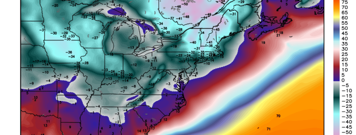
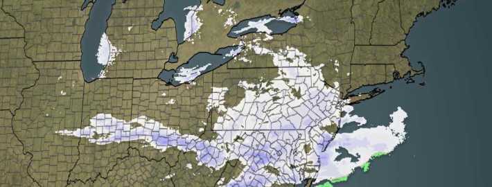
For the winter lovers out there, the only thing currently missing on the checklist is a solid snow pack. Light snow will fall during the remainder of the morning and afternoon on Tuesday, bringing light accumulations to the majority of the area. As a clipper system shifts eastward, the snow will eventually wrap up from west to east Tuesday afternoon and evening — but not before snow squalls move through the area as well. This will leave a bittery cold and somewhat snowy scene throughout the area. Temperatures Tuesday evening will fall into the teens — and highs on Tuesday afternoon will only be in the lower 20’s.

While accumulations are expected to be light, roads may still become slick and slippery. The snow will accumulate fairly easily. We anticipate some travel delays due to this, so leave some extra time if you’re going to be commuting this morning or even this afternoon and evening. The main story, after the snow wraps up, will become the bitter cold which will surge into the area during the middle part of this week.

Read more

Clipper on Tuesday to be followed by Arctic Blast

Is winter finally arriving? The 50-degree weather and rain we’re currently having certainly doesn’t signify that, but the weather will be turning much more wintry starting tomorrow and potentially lasting for one week or longer. On the back side of the current storm system, a cold front has formed and will be approaching us this afternoon. Southwesterly winds will be increasing and temperatures will generally be in the mid 50s. There is the chance of another downpour during the mid-afternoon, before the cold front crosses this evening, creating a dramatic shift to our weather.

Winds will shift to the northwest from 15-20mph and will gust to around 30mph at times. Temperatures will plummet into the upper 20s and low 30s tonight, with Wind Chills in the low 20s. The continued cold air advection tomorrow will not allow temperatures to get out of the mid to upper 30s tomorrow afternoon. That in itself is certainly not brutal, but it’s a huge change from what we’re seeing today. On the bright side (no pun intended), there will be sunshine tomorrow.

The next feature to watch will be a weak Alberta Clipper for Tuesday. On Monday night, a cold high pressure system will be building in, bringing in a reinforcing shot of cold air, with low temperatures in the upper teens to lower twenties. This will allow temperatures at the surface, and particularly aloft, to be plenty cold for snow.

Read more