What we know about Monday’s potential snowstorm

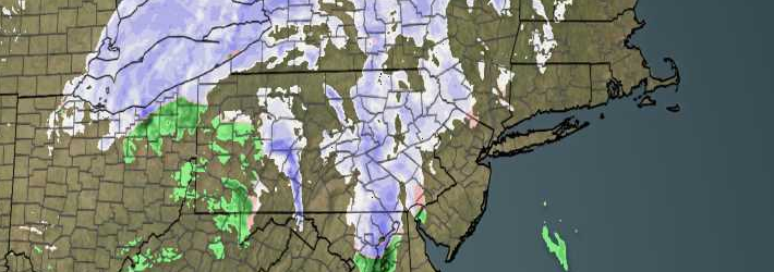
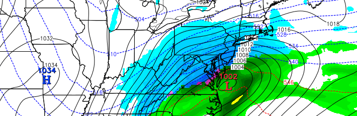
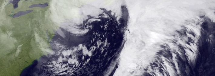
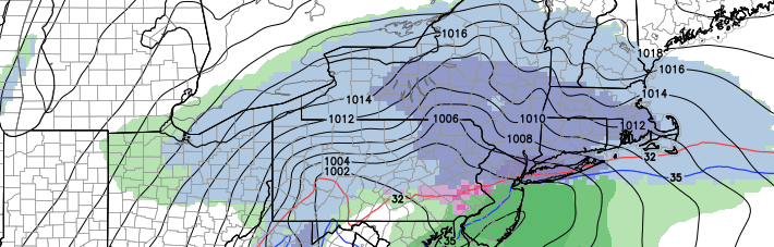
On the heels of a low pressure system which brought light snowfall to the area on Friday, a shortwave will drive southward through the Plains states on Saturday. Coming over the top of a mid and upper level ridge on the West Coast of the United States, the shortwave is forecast to amplify southward from the Plains states through the Mississippi and Ohio Valleys by Sunday. As a result, a surface low pressure will form and move from the Mid Atlantic States to a position off the Northeast Coast by Monday morning and afternoon.

Forecast models have been struggling to pin down details in regards to the mid and upper level features which will characterize the storm system. Earlier this week, models were in good agreement that the storm system would take a more southerly track. With the surface low moving from the Mississippi Valley to the Southern Mid Atlantic Coast, the main concern for our area would be precipitation staying too far south for meaningful snowfall. But in the past 24 hours, a noticeable trend toward a more amplified solution has emerged. Forecast models now track the system off the coast of New Jersey — raising concerns that precipitation type may change to sleet or rain across portions of the area on Monday.

Read more

PM Update: Periods of snow, light accumulations tonight

A quick blitz of snow will approach the area over the next several hours, especially across northern sections of the forecast area. Precipitation could briefly mix with sleet and rain in some areas, especially further south and near the coast. The precipitation comes out ahead of a low pressure system which is driving southeastward through Southeast Canada. Mid level energy will eventually force the low pressure system to redevelop in the Gulf of Maine, as a stronger low pressure system which could bring several inches of snow to the Maine Coast.

Closer to home,snow and mixed precipitation will lead to an increased risk of hazardous travel tonight. Although not a significant winter weather event by any means, briefly moderate snow could cover roads — especially those that are untreated. The precipitation is expected to pick up in intensity after dinner time and continue into the middle hours of the evening.

Read more

Cold, active winter pattern will continue

Whether your area got hammered or only moderately brushed by the Blizzard of 2015, it is clear that the pattern has finally truly shifted towards a cold and snowy regime. This month has generally featured -3F temperature departures with above average to much above average snowfall for the region. While it is not a lock that a lot more snow is in the immediate future, the cold and active weather will continue. This means that there will be a few chances of snow, but does not guarantee anything.

The main feature that has continually supplied our cold air this month is a large amount of ridging over the Pacific. The location of this ridging has ranged from  Alaska to British Columbia including the west coast/western half of the US. These help to favor troughing downstream, or in the Eastern US. Particularly, when the ridging extends far enough north to poke through the British Columbia and into Alaska, you can somewhat displace the Polar Vortex to the south, which creates a nice cold air source to our north for winter storms. This was part of the pattern that preceded the Blizzard, and this part of the pattern looks to generally continue.

Read more

It’s Tuesday Morning: What the hell happened?

I think we’re best to start off by saying this: Today is a really, really tough day for meteorologists. As everybody wakes up and steps to their window, they’re going to be disappointed in the amount of snow that has fallen. The exception will be over interior Connecticut, Long Island and New England — where the Blizzard of 2015 did bring the anticipated snowfall accumulation. Elsewhere, disappointment will be widespread as snow totals only added up to those of a moderate to significant snowstorm. The prolific snowfall amounts, seeded somewhat by hype but then backed up by our best computer models just mere hours before the storm, did not and will not come to fruition. Which leaves us only with one question: What the hell happened?

Back on Sunday evening, in our post breaking down the potential event, we included this very important piece of information: ” Very heavy snow will spread northwestward from the Western Atlantic to the NJ Coasts and Long Island by late Monday Night into the wee hours of Tuesday Morning. The westward extent of this precipitation shield is currently extremely uncertain — and will determine whether the storm is significant to major, or historic. In this heavy banding, snowfall rates of 2-4” per hour at times are likely.”

Read more