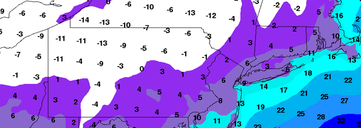
Multi-wave winter weather event possible next week

A multi-wave winter weather event is increasingly likely to unfold during the early to middle part of next week across a large majority of the Northern 1/3 of the United States, initially in the Great Lakes and then northeastward into New England. The exact area where this winter weather potential sets up obviously remains highly uncertain. Forecast models have been extremely inconsistent in handling mid and upper level features which will eventually have major impacts on the sensible weather experienced by many. But in this case, there are clues in the meteorological pattern that point to the answers to some of our questions. Instead of looking specifically at forecast models and their trends, we can begin to look for answers to our questions in the hemispheric pattern. 

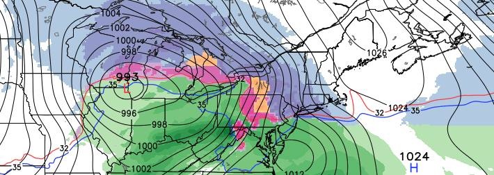
The winter weather threat traces its roots back to the total degradation of the West Coast ridge and positive PNA on along the West Coast of the United States into British Columbia. Inherently, this is a bad sign for snow lovers on the East Coast Any time we degrade a PNA ridge there is a positive mid and upper level height field response to the east of that over the Southeastern United States. In fact, the collapse of a PNA ridge can bring a response all the way into the Western Atlantic. As the amplified pattern out west collapses, the mid level jet collapses east into the Untied States and allows for the flow to enhance further to the east. So not only does the Southeast Ridge suddenly gain amplitude, but the pattern becomes more progressive over the Great Lakes and Southeast Canada — working against snow chances in the East. 

Read more

Nantucket now has awesome slush waves

It’s so cold, the ocean is freezing over! No, not really. But parts of it are, especially shallower areas and the top layer of the water near the beaches of Nantucket. This phenomena hasn’t been seen in many years since, well, it hasn’t been this cold in many years. But the prolonged record breaking cold air which settled over the Northeast US over the past 30 days has brought some incredible sights. The Hudson River has large masses of ice floating down it, and now the beaches of Nantucket have “slushy waves” crashing onto the shore.

These waves are the same as any other ocean wave, except for the fact that the surface of the ocean is covered with slushy ice. The top layer of the ocean waters are very close to freezing over — but the temperature of the water isn’t quite supportive of that especially given continued water movement and the waters depth. So what you get is a layer of slush and pockets of icy water on the top, creating an amazing scene as the waves crash ashore. These are known in the area as “slushy” or “slurpee” waves.

Read more

PM Update: More cold, but what about snow?

After another Arctic day yesterday, today feels tropical in comparison with temperatures in the mid 30s. Is this a sign that winter is losing its grip? Not quite yet.

Several more low temperature records were broken yesterday. For more perspective on how cold it has been, check out the article we published this morning. While widespread record cold is likely done, we may have another night or two left of single digit cold, which is still truly remarkable for this time of year. Overall, below average temperatures and chances for snow will continue for the next 7-10 days.

The first chance for snow comes tomorrow. A snowstorm is developing in the deep south, and is expected to give parts of North Carolina and Virginia up to a foot of snow. Usually, snowstorms of this variety do not come far enough to hit our area, and this is expected to be the case. Having said that, storms that develop near the Gulf  tend to come in a bit further north than forecast (see the cold, 3-5″ of fluffy snow we got last Monday night into Tuesday). These southern waves tend to pump up a lot of heat and moisture which give a feedback effect to amplify the pattern for them to come a bit further north than they normally would.

Read more

A flicker of light at the end of the tunnel

The ice still crunches on your way out the door as brutal arctic cold hits your face. A hard reminder of the fact that we still are, truly, in the heart of a historic winter. The audible sounds of spring so far, while increasingly present, have been muted by the noise of one of the harshest winters in recent memory. The cold wind still blows, ice scrapers are still heard on car windshields, and the distant intermittent beeping of a snow-plow in reverse still serves as a background to each morning. But, if one were to listen closely, there are sounds of change in the air. Beyond the sounds of the winter are the increasingly audible chirping of seasonal birds, the dripping of melting snow, and the sounds of water on the area roads from melted thick ice.

The change continues to build, and it is not limited to sensible meteorology effects. Playoff hockey is only months away, pitchers and catchers are pitching and catching in Tampa, radio shows are discussing whether the Mets will finish last or second to last in the National League East this season. Our seemingly weekly “Winter Storm Possible” post hasn’t gone up this week, because there is no need for it yet. The sun angle is changing, and sunsets are later — almost to 5:45 now. In just one month, the sun won’t go below the horizon until 7:20pm.

Read more