We’re shipping up to…Provincetown

Call us crazy. But we’re heading up to Provincetown, the northern tip of Cape Cod, for the upcoming Nor’Easter this weekend into Presidents Day. And while this may seem somewhat insane to you given the degree of snowfall in New England and the predicted power of this Nor’Easter, look on the bright side: You’ll get to experience the wrath of the Nor’Easter through our website. For us, this is likely to be the thrill of a lifetime. Don’t worry — we’re still fully staffed for the storm in New Jersey, New York City, and Long Island.

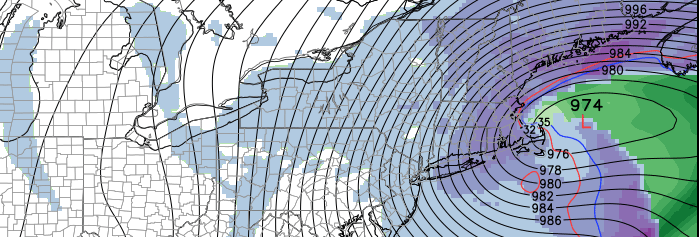
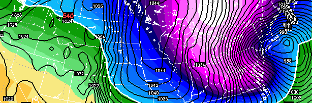
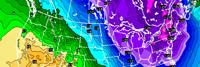
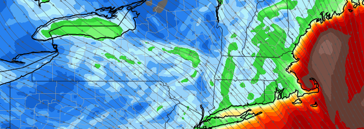
Forecast models are in good agreement on the track of the Nor’Easter — which will move from the Northeast States to a position off the coast of New Jersey and eventually southeast of Cape Cod and into the Gulf of Maine. Meanwhile, a mid level center will shift south of Long Island and Southeast of Cape Cod, with impressive mid and upper level dynamics driving the potential for heavy precipitation. Snow is expected to develop later Saturday and continue into Sunday, when it will be heavy at times.

Read more

Snow, cold, strong winds possible this weekend

Forecast models have come into much better agreement on the eventual track and intensity of a powerful storm system, which will develop from the Great Lakes off the Northeast Coast on Sunday. The track of the storm is quite unusual, with the surface low tracking from Southeast Canada to a position off the New Jersey Coast and eventually into the Gulf of Maine. A powerhouse mid and upper level low will amplify eastward from the Great Lakes, underneath Long Island, and eventually to a position just south and east of Cape Cod, aiding the strengthen an already powerful storm system.

The result will be the potential for snow from Sunday into Monday, with moderate snowfall accumulations and the potential for higher amounts farther east. But in addition to the snow will come strong, damaging wind potential as the system deepens offshore. Finally, behind the storm, a polar airmass will move southward — possibly the coldest in many years — and the coldest air of the season will sink into the area on Monday when temperatures may struggle to get out of the single digits.

Read more

Significant storm possible this weekend, details uncertain

Here we are again. Over the last day or so, forecast models have begun to come into agreement on a potentially significant Nor’Easter developing late this weekend into early next week. With a polar upper level low and associated shortwave energy dropping southward from Canada into the Great Lakes, a storm system will develop off the Northeast Coast of the United States on Sunday. But the devil, as always, is in the details. The exact positioning, orientation, and intensity of the mid level energy as it moves toward the coast will have significant impacts on where the coastal storm develops and how strong it is.

Not surprisingly, forecast models have been struggling to pin down the exact track and location of the aforementioned coastal low. Once it develops off the Northeast coast, there is good agreement on one thing: The storm will deepen rapidly. But the location where this occurs depends greatly on the track of the mid and upper level atmospheric energy. Some forecast models take this energy farther north, through New England, and develop the surface low too far north to affect our area. But others track it farther south, allowing the low to develop off the coast of New Jersey and bring snowfall to our area Sunday into Monday.

Read more

Arctic cold, multiple chances for snow through next week

We don’t have it as bad as Boston. Yet, multiple freezing rain and winter weather events have made their way through our region over the past several weeks just the same. Freezing rain, sleet and snow have become mainstay’s in the weekly weather. And the repetitive pattern has many wondering when winter will finally end. Unfortunately, that does not look to be any time soon. While not everything in our current weather pattern screams in support of a major snowstorm, there are widespread indications that arctic cold and multiple chances for Nor’Easters will show their face from late this week into next week.

Both time periods will be evolving remarkably similarly aloft. Over the next few days, a large mid and upper level ridge will begin amplifying on the west coast of the United States, and  powerful shortwaves with potent energy will be diving down from Canada on the eastern periphery of that ridging. The first potential event, this coming Thursday into Friday, looks likely to remain progressive enough for our area to avoid significant snowfall. While the pattern is amplified in the mid levels, it remains slightly progressive — without any high latitude blocking to slow things down. As a result, the developing surface low looks likely to slip just far enough east.

Read more