Prolonged period of wintry weather to start the week

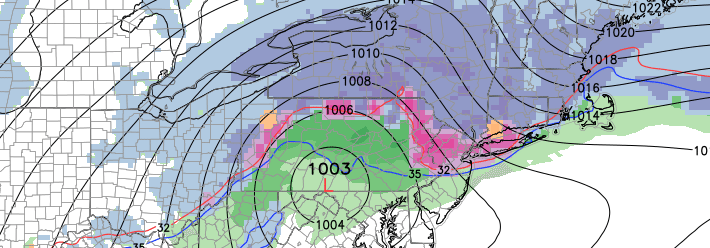
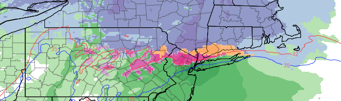
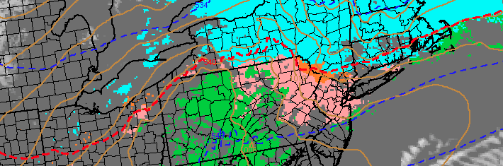
A winter storm affecting the Northeast United States will begin as early as Sunday throughout the area, as lift for precipitation develops along a baroclinic zone and thermal gradient near the area. The forecast in terms of precipitation type and amounts, however, is not as cut and dry as it may seem. The thermal gradient both at the surface and aloft will differ in location, creating widespread differences in precipitation type and a very sharp gradient in potential snowfall and winter weather impacts.

In the mid levels, warming will occur between 850-900mb (above our heads, but not very far up in the atmosphere). This warm layer will push northward to a position near New York City on Monday. What this means, is that any snowflake which forms farther up in the atmosphere will fall through a layer of air that is above freezing. Essentially, it will melt. But our problems don’t stop there — the surface layer of the atmosphere (where we are) is very cold. And that means any precipitation which falls as liquid is going to re-freeze on the surface.

Read more

Monday’s snow threat trends north, still a concern

The winter weather potential for late this weekend into early next week has been well advertised. A low pressure system is forecast to develop from the Ohio Valley into the Northeast states late this weekend, along a thermal gradient otherwise known as a baroclinic zone, and force the development of precipitation in the Northeast States. Forecast models, however, had been displaying tremendous uncertainty with the positioning of that thermal gradient — uncertainties which were well documented. The past 48 hours have seen forecast models trend farther north with the thermal gradient, changing the complexion of the storm threat completely.

What this means for our area, is that precipitation type and amounts become less certain. The thermal gradient, essentially, is a boundary where there is a large temperature gradient over a short distance. Along and just north of this zone, enhanced lift for precipitation can occur as the development of a low pressure system is promoted near or just south of it. With this gradient trending north, forecast models have introduced warmer temperatures in the mid levels, and have shifted precipitation northward into New England.

Read more

Multiple winter weather threats to begin February

On the heels of two (arguably three) major winter weather events in the Northeast United States, many are wondering just when the pattern will slow down. The answer: Not soon. Medium and long range forecast models are in good agreement that  an active pattern will continue in the foreseeable future as the Pacific Jet continues to send multiple disturbances into the United States. Fluctuating amplitude of both a ridge on the West Coast and high latitude blocking over the Arctic regions will keep things from getting downright snowy and cold for a prolonged period, but the potential for winter weather events for at least the first few weeks of February looks to be heightened.

The first threat will come as early as the tail end of this week — small, but nonetheless noteworthy as it comes on the heels of an arctic front. Short term forecast models are in agreement that a wave of low pressure will develop along this frontal boundary on Thursday, with moisture streaming north/northeastward along it. The best support for heavy precipitation will remain well offshore. But enough moisture looks to stream along the front within a coupled jet structure aloft to allow for steady precipitation to push eastward from Pennsylvania through New England and the Northern Mid Atlantic.

Read more

Why Monday’s storm will disappoint NYC snow lovers

Much has been made over the past few days about a potential winter weather event in New York City on Monday morning. Vindication, they’ve called it. After the Blizzard of 2015 barely skirted our area and brought historic snowfall to New England, this Monday’s event was seen by snow lovers as the makeup-call to our blown chance last week. But, we say, not so fast. Despite what forecast models have hinted at over the past few days, there are meteorological elements to this storm system which not only argue against significant snowfall in New York City — but in fact, argue for a few inches of snow followed by sleet and then plain rain. A snow lovers nightmare.

For those who aren’t enamored by snowfall in New York, this article will serve as a bit of detail and an opportunity for understanding some atmospheric processes which are going to be occurring on Sunday Night into Monday Morning. There is a method to the madness of meteorologists, despite what the public opinion may have been on Tuesday morning when most woke up to much less snow than they anticipated.

Read more