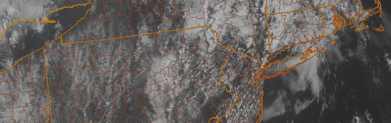
Yankees Forecast: Again dodging showers and storms

We’re excited to bring you weather forecast information on the days of Yankees, Mets, and other outdoor sports team home games in New York City. If any inclement weather is anticipated, this forecast will include a breakdown of the hazards and timing. If delays or postponement appear possible, details will be provided.

Showers and thunderstorms will again be possible this afternoon and early evening, developing from the west and moving east/northeast. Periods of heavy rain are possible as they move through the area.

Read more

Afternoon roundup: More humid, still unsettled

Rounds of clouds associated with increasing low level moisture surged into the area today, and they have broken up in coverage a bit this afternoon as daytime heating has increased. This daytime heating is, however, a bit of a blessing in disguise. Increasing atmospheric instability as a result of more sunshine will help to touch off additional storms this afternoon within a very moist environment. These showers and storms aren’t expected to be severe, but they could bring a period of unsettled weather to parts of New Jersey and New York City. These storms will eventually slip east/northeast of our area tonight, with some clearing expected. The unsettled weather will continue as a frontal boundary approaches the area Wednesday morning. Here’s a roundup of news and information from the meteorological community today:

  • Unsettled weather will continue in our area, with a round of showers and storms this afternoon. They aren’t expected to be severe, with the Storm Prediction Center only indicating a chance of general thunder and no organized strong or severe storms. Still, a period of heavy rain and possibly a few lightning strikes are possible as they move through.
  • Forecast models are fluctuating with the potential for a more organized area of showers and storms on Thursday Night and Friday morning. If it does move through, a period of steady or heavy rain would be possible. Some models bring it through our area, others track the system farther south.
  • Unsettled weather will finally depart for the weekend. Models are in good agreement that a high pressure system will build in, with highs in the upper 80’s and partly cloudy conditions. Lower humidity a calmer conditions aloft will limit the chance for showers and storms.

Yankees Forecast: Humid, dodging a few storms

We’re excited to bring you weather forecast information on the days of Yankees, Mets, and other outdoor sports team home games in New York City. If any inclement weather is anticipated, this forecast will include a breakdown of the hazards and timing. If delays or postponement appear possible, details will be provided.

Showers and thunderstorms will be possible this afternoon and early evening, developing from the west and moving east/northeast. These storms are not expected to be severe, but may bring periods of moderate to heavy rain.

Read more

Warmer, muggier to start the week

Regardless of clouds and isolated showers, this weekend ended up being quite pleasant. The sun was out slightly more than anticipated, and heavy/steady rain generally stayed away from the area. So did the big time heat and humidity, and unfortunately the latter will return to the forecast during this week. Humidity values have already noticeably increased as of Monday afternoon, and rising temperatures will make the air feel uncomfortable this afternoon. Scattered showers and storms will be around, but won’t be widespread.

These showers and storms, a function of a transient mid level atmospheric disturbance, will essentially hang around in the forecast for most of the week. While temperatures won’t be “hot” by any means (they’ll top out in the 80’s for the most part), the general airmass will feel uncomfortable and the weather will remain unsettled. Scattered showers and storms will be possible each afternoon within the humid and slightly unstable airmass in place.

Read more