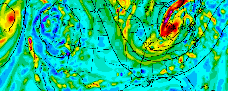
High pressure will gradually shift to the northeast Friday night and Saturday. Clouds will increase on Friday night. An amplifying ridge over the Western United States will cause shortwave energy to dig and form into a closed upper-level low over the Ohio Valley/Great Lakes. This will cause a double-barrel surface low-pressure system to organize over the Eastern US on Saturday. A deep southerly flow will transport a plume of moisture from the Gulf of Mexico and the Atlantic into our area. Most of the model guidance agrees on a widespread heavy rainfall throughout the area starting on Saturday and continuing into Saturday night.
Saturday will feature mostly cloudy skies with some intermittent rain and drizzle breaking out from southwest to northeast across the region. This will gradually occur during the morning and early-afternoon hours. A strengthening southerly low-level jet and precipitable water values approaching two inches will cause rain to become steadier and heavier at times, late in the afternoon and early Saturday night for the region.
https://www.nymetroweather.com/wp-content/uploads/2015/06/12znamUS_500_avort_063.gif600800Miguel Pierrehttps://www.nymetroweather.com/wp-content/uploads/2024/02/Empire-2000-x-300-px-2.pngMiguel Pierre2015-06-25 09:48:182015-06-25 16:06:11Weekend Outlook: Heavy Rainfall Late Saturday, Better Weather on Sunday
Some have told us that last nights sunset was the “best they’ve ever seen”. While that certainly is a variable statement, the sunset which cast New York City and New Jersey in orange and red hues after Tuesday’s storm was certainly one of the best in recent memory.
After strong and severe thunderstorms brought tornado warnings, hail, wind, and dangerous lightning to much of the area, clouds began to thin out in the wake of a cold front. The result was multiple quick moving cloud decks. Mid level clouds created a beautiful layer as low clouds swept by, and the departing Suns red and orange Rays were able to shine off both of them.
The resulting photos were both phenomenal and captivating with their colors; exposing both the beautiful colors and amazing landscape we are fortunate enough to be able to experience. We have included some of our favorites below. If you have some of your own, reply or email them to us!
Wow, what a day! Tuesday was one of the more active severe weather days in recent memory. Tornado warnings, destructive winds and downbursts, dangerous lightning, and hail were all a part of the forecast. A tremendous amount of damage reports were received (we’re still sifting through them) and post-analysis will begin very shortly. The good news? The frontal system has moved offshore, and Wednesday will feature much more pleasant — and most importantly, calm — conditions.
Highs will still reach into the 80’s, so it won’t exactly be blustery or chilly out there. But the heat and humidity which gripped the region on Tuesday ahead of the severe thunderstorms will be washed out. The result will be much more comfortable feeling air. Northwest winds will keep things fresh, and the full sun will keep the air warm.
12:30pm: This morning, we initially had a strong area of showers and rumbles of thunder in Pennsylvania that was moving toward our area. if it hit us, the atmosphere would have stabilized and the severe threat for thunderstorms would have significantly gone down.
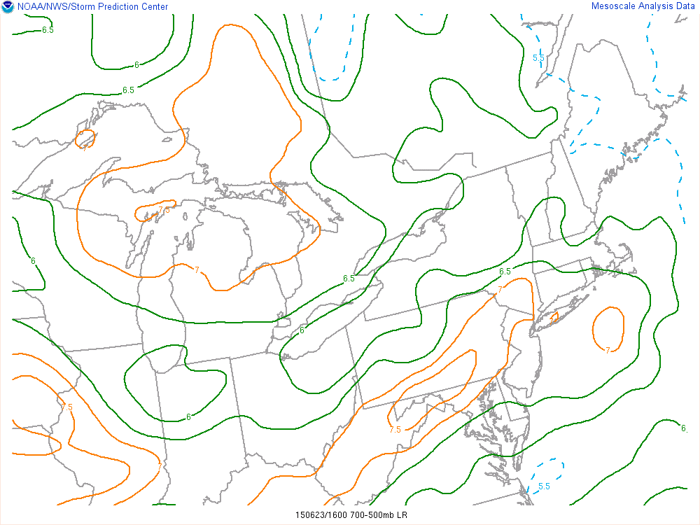
Current SPC Mesoanalysis as of noon shows an area of mid-level lapse rates in excess of 7C/KM in our area. This is very significant, as it leads to plenty of instability in the middle of the atmosphere, as well as providing a capping inversion below it that weakens any weak convection and keeps us sunny and unstable.
However, the EML we discussed yesterday was able to work its way into the region and provide a capping area that completely disintegrated this area of showers. This means that clouds will quickly be disintegrating, and we will quickly be able to destabilize the atmosphere, making it very ripe for severe weather.
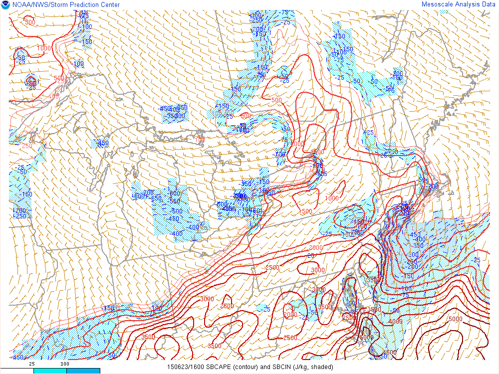
Current Mesoanalysis from the SPC shows already building values of surface-based CAPE.
In fact, surface-based CAPE values are already in excess of 3,000 J/KG in many areas, which is actually ahead of schedule. When this is combined with the strong mid-level lapse rates and strong wind shear, severe weather is expected to hit a decent chunk of our area later this afternoon. The primary threat will be damaging wind gusts and vivid lightning, but large hail is also a threat, and a tornado threat is non-zero.
—–
An energetic mid level disturbance, impressive wind shear, and moderate to significant atmospheric instability will combine to create an enhanced threat for organized severe thunderstorms in the Northeast US on Tuesday. While some uncertainties still exist in regards to exactly how the event will unfold, confidence is rising in the heightened threat for severe thunderstorms — even in the NJ and NYC Metro Area. While not everyone will experience a severe storm, the threat for organized thunderstorms is much higher than normal today.
Thunderstorms are forecast to develop over Northern Pennsylvania and New York State, and begin progressing southeastward throughout the day. Meanwhile, atmospheric destabilization will occur over much of New England, the NYC Metro, New Jersey, and the Mid Atlantic. Instability parameters are expected to be quite high, especially by Northeast US standards. With more than adequate wind shear for thunderstorm organization, these storms are expected to spread southeast toward the coast during the late afternoon and evening.
This post will serve as a Live Blog throughout the day for updates and information on the latest analysis as well as a relay point for Watches and Warnings from the Storm Prediction Center and Local NWS offices. A de-brief on the threat is below:
https://www.nymetroweather.com/wp-content/uploads/2015/06/Screen-Shot-2015-06-22-at-11.25.00-PM.png240756John Homenukhttps://www.nymetroweather.com/wp-content/uploads/2024/02/Empire-2000-x-300-px-2.pngJohn Homenuk2015-06-23 07:20:112015-06-23 12:38:35Severe thunderstorms possible this afternoon and evening
Hi friends! Our website uses cookies to provide an optimal browsing experience for you. New "Cookie Consent" laws mandate us to inform you of this. As long as you're cool with it, just hit OK. You'll only see this message once.
We may request cookies to be set on your device. We use cookies to let us know when you visit our websites, how you interact with us, to enrich your user experience, and to customize your relationship with our website.
Click on the different category headings to find out more. You can also change some of your preferences. Note that blocking some types of cookies may impact your experience on our websites and the services we are able to offer.
Essential Website Cookies
These cookies are strictly necessary to provide you with services available through our website and to use some of its features.
Because these cookies are strictly necessary to deliver the website, refusing them will have impact how our site functions. You always can block or delete cookies by changing your browser settings and force blocking all cookies on this website. But this will always prompt you to accept/refuse cookies when revisiting our site.
We fully respect if you want to refuse cookies but to avoid asking you again and again kindly allow us to store a cookie for that. You are free to opt out any time or opt in for other cookies to get a better experience. If you refuse cookies we will remove all set cookies in our domain.
We provide you with a list of stored cookies on your computer in our domain so you can check what we stored. Due to security reasons we are not able to show or modify cookies from other domains. You can check these in your browser security settings.
Other external services
We also use different external services like Google Webfonts, Google Maps, and external Video providers. Since these providers may collect personal data like your IP address we allow you to block them here. Please be aware that this might heavily reduce the functionality and appearance of our site. Changes will take effect once you reload the page.
-2")