(Premium) Will Warmer Weather Return Next Week?

After much warmer than normal temperatures during March, April has averaged cooler than normal so far, with some unseasonable cold weather for some days. This weather might seem bit ironic since we’re moving further into the Spring season. Some major league baseball games have to been postponed due to more unseasonably cold weather and even wintry precipitation in Northern parts of the nation. There are signs of a warming trend going into this weekend and early next week. But there are signs that this may be interrupted again due largely to high-latitude blocking.

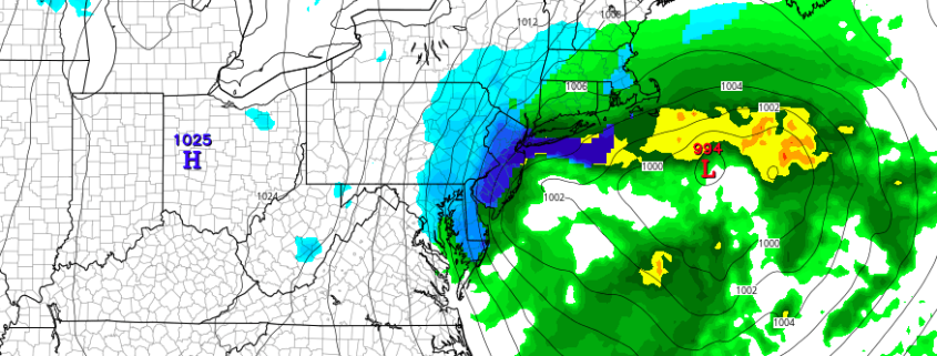
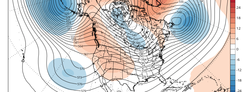
Later this week, a large, deep cut-off low over the Rockies will cause a strong ridge to build over the Great Lakes and Ohio Valley regions. Another cut-off low will form on the downstream side of the ridge, off the East Coast. Initially, model guidance showed this cut-off low backing towards the region and affecting our weather this weekend. But high-latitude blocking weakening this week allows this low to remain farther offshore.

Read more

Monday Musings: Warmer, unsettled, cutoff low

So far, Spring 2016 has been absent, despite calendar arguing otherwise. The trend looks to continue this week, and as we look forward into the medium range, forecast models suggest it may continue even further into next weekend. While we aren’t quite looking at snow, the weather looks likely to be cooler than normal — all thanks to an unsettled pattern through midweek, and then a cutoff low which may impact the area thereafter. The story begins on Monday, as a southwesterly flow brings increasing clouds and the potential for showers.

A frontal system will swing through the area on Tuesday, with a period of steady rain possible along the frontal boundary. While the end of the week may be warmer and drier, the potential for a cutoff low exists later this weekend. This idea gains credence given the presence of high latitude blocking, extending essentially from Greenland into the Western Atlantic Ocean, acting like a “wall” to prevent any disturbances from escaping. But, more on that later. Here are the highlights to start the week:

Read more

(Premium) Dynamic cooling may bring snow to some on Saturday

While the calendar has pointed to Spring for several days, the weather pattern has not cooperated. This weekend will be no exception. Forecast models have come into better agreement over the past few days regarding the eventual development of a low pressure system off the Mid Atlantic coast, which will form as a result of a powerful mid level atmospheric disturbance dropping southward from Canada into the Great Lakes and Northeast.

A low pressure system is likely to develop from the Ohio Valley into the Mid Atlantic and off the coast of New Jersey. Precipitation is likely to develop on the northern end of the storm system, as moisture pushes northward from the low pressure area. This will allow for bands of precipitation to develop towards our area, likely falling as rain. The antecedent airmass is quite warm, and likely supports rain over any frozen precipitation, with melting of snowflakes occurring in the lower levels of the atmosphere. However, there is one main caveat in the setup: The potential for intense banding and dynamic cooling, producing heavy snow over some areas.

Read more

Friday overview: No signs of spring, other than baseball

Cold air has returned to the area this morning, which you’ve probably already noticed. This airmass will continue pushing into the area over the next several hours as west-northwesterly winds usher in the drier and colder airmass. A few scattered showers are possible today, but should remain generally un-impactful. The main story over the next day or two will be the potential for snow (yes, you read that correctly) on Saturday with a system developing off the coast of New Jersey.

Models are in agreement that a strong shortwave and atmospheric disturbance will drop southeastward from Canada into the Great Lakes and eventually underneath the Mid Atlantic states on Saturday. This is a pattern that is much more typical in January of February — not in April. Nevertheless, the storm system is well signaled on all models. The question, over the next several hours, will be pinning down when and where heavy precipitation will occur. Essentially, while most areas will experience rain with this storm, heavier precipitation rates can allow for “dynamic cooling” in the atmosphere, allowing precipitation in heavier bands to fall as snow.

Read more