Thursday Overview: Unsettled start, nicer finish

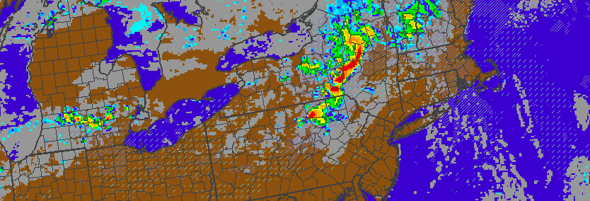
The long stretch of sunshine and pleasant weather has ended! Well, sort of. A disturbance passing by this morning will bring periods of rain to the area, especially areas south and west of New York City. While clouds and showers will stick around for parts of the morning, clearing is expected as the day progresses.

Forecast models show the cloud deck meandering near the city itself, with partly to mostly cloudy conditions over Long Island and Connecticut. Meanwhile, much of Central and Southern NJ will battle showers until the late morning or afternoon hours. Once this disturbances slides seaward, however, clearing is expected throughout the area.

Read more

Strong storms possible Saturday, but uncertainty remains high

A complex atmospheric pattern is expected to unfold on Saturday, and the evolution may lead to the potential for strong to severe thunderstorms in the Northeast states. As a mid level ridge builds toward the area from Friday Night into Saturday, a disturbance associated with a thunderstorm complex in the Northern Midwest states will ride over the top of this ridge, eventually diving southeast from Southeast Canada into the Northeast on Saturday. But, as you can imagine, forecast models are struggling with the exact details of its movement through the area.

Convection, inherently, is difficult to forecast. Models are likely to struggle with this disturbance as thunderstorms develop today over the Northern Midwest and head toward parts of the Great Lakes. More importantly, this disturbance will move northeastward into Southeast Canada, along the periphery of a mid level ridge, and then dive southeastward into our area later Saturday — and the timing of its approach becomes critical to the forecast.

Read more

Premium Weekly Outlook 6/06 – 6/12: Anomalous ULL dominates the week

Much of this week will be dominated by a large anomalously cold upper-level low moving eastward into the Hudson Bay and Southeast Canada. After a dry day today, a couple of disturbance rotating underneath this upper-level low will be moving across the region on Tuesday and Wednesday. This could give us more clouds and chance for a few showers or thunderstorms each day. Then high pressure will settle in for more fair weather late in the week. But some troughiness will still linger over Southeast Canada and the Northeast through this weekend, with another shower and thunderstorm threat. A more technical discussion for this week is below.

For the rest of this afternoon, temperatures will remain in the lower the middle 80s for much of the region with west to southwest winds and plenty of sunshine. A sea-breeze could develop near the shore and bring temperatures down a few degrees. Mostly clear skies will continue into this evening, then some clouds will be increasing during the overnight hours. These clouds will be from a disturbance passing north of the region, and also streaming northward from Tropical Storm Colin, which will track into the Southeast US later tonight and then out to sea later on Tuesday. Temperatures will drop into the upper 60s to lower 70s. 

Read more

Localized severe thunderstorm event possible Sunday

A complex weather system will shift toward the area from late Saturday into Sunday, with tropical moisture surging northward as it moves into parts of the Northeast United States. The main surface low pressure area will track into Southeast Canada, while a secondary low pressure area will dip southward into New York State and New England. This will help draw in more southerly winds with moist, unstable air making its way toward the area as Sunday goes on.

At the surface, a warm front will move northward from the Mid Atlantic states towards Central New Jersey by Sunday afternoon. As it does so initially, showers with embedded thunder will likely shift northeastward through the area. Occasionally torrential downpours are anticipated as it does so. The main story, however, will come during the afternoon as the warm front sets up shop near Central New Jersey on a west to east axis.

Read more