Weekend Overview: Excessive Heat & Scattered T-Storms for Saturday and Sunday

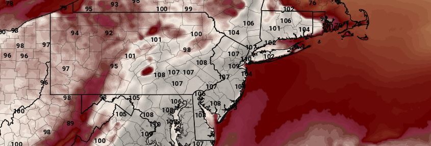
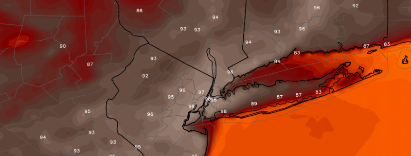
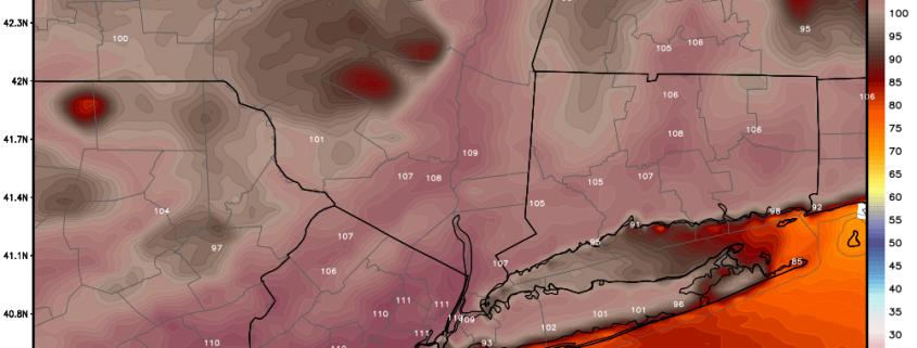
Oppressive heat and humidity will continue through Sunday with a strong upper-level ridge over region.  Temperatures are already approaching the upper 80s or lower 90s late this morning. High temperatures will be middle to upper 90s both Saturday and Sunday, over much of the region. Heat index values will be between 105F to 110F this afternoon. Therefore the National Weather Service now has excessive heat warnings for most of the region through Sunday. Take precautions to stay well-hydrated, while outdoors this weekend.

Some scattered showers and thunderstorms are possible during the afternoon and evening hours today and Sunday. A lack of deep layer shear and large scale forcing will likely inhibit more organized or widespread severe weather threats in the region. But with extreme levels of instability and moisture in the atmosphere, a few thunderstorms could become strong or severe with gusty winds, torrential downpours and frequent cloud to ground lightning. Some other highlights.

Read more

Oppressive combination of heat and humidity this weekend

We have all experienced high temperatures before. In fact, most of us sat underneath a large ridge of high pressure earlier this summer which brought us temperatures in the upper 90’s. This weekend, however, temperatures will again surge into the upper 90’s — and combine with dew points in the middle to upper 70’s to bring Heat Index values near 110 F for periods of time each afternoon. This air, not surprisingly, will feel overly oppressive.

The culprit? The positioning of the aforementioned ridge in the mid levels of the atmosphere. Earlier in July, our area experienced a prolonged period of heat. But the ridge axis was centered in the Plains States. A clockwise flow around that ridge axis brought the heat into our area from the Northwest, meaning dew points were lower and the heat was of the “drier” variety. This time, the ridge is centered off the Southeast US Coast, with the clockwise flow around the high pressure bringing the heat into our area from the southwest.

Read more

Thursday Overview: More heat builds through Saturday with scattered t-storms possible

More heat will build through Saturday with a strong ridge over region. More sunshine is expected to mix with clouds this afternoon. This will help temperatures reach into the lower to middle 90s today over much of the area today. But with surface dewpoints in the 70s, heat index values alone will be in the middle to upper 90s. The National Weather Service has heat advisory for NYC for today through Saturday. Excessive heat warnings are also in effect for the Philadelphia metro region through Saturday.

Due to the unstable, hot and muggy airmass, some widely scattered showers and thunderstorms are possible over the next few days, especially during the afternoon and evening hours. The main threat will be some torrential downpours and frequent lightning with weak shear and tropical moisture. Otherwise it will be mainly dry with more sunshine.  Some other highlights over next few days.

Read more

La Nina Update: Moderate or Strong Event Unlikely This Year

While we had been tracking heat and severe thunderstorms over the first few months of the summer, the atmosphere was still undergoing a major transition away from El Nino and towards a La Nina. This transition has already resulted in sensible weather changes across much of the country, with a huge heat ridge building in the Central US last month — typical of a La Nina. However, to the despair of some long range forecasters, certain aspects of the transition have not gone as smoothly, and more recent forecast models have trended weaker with the eventual strength of the La Nina over the next few months.

During last year’s El Nino conditions, the trade winds in the Equatorial Pacific were strongly weakened, allowing warm water near Australia to pool eastward. Those trade winds have strengthened over the last few months, which pushed that warm water back to the west, and allowed cooler water to upwell towards the surface. However, climatology favors trade winds remaining a persistent feature — in other words, we are supposed to have east-to-west trade winds blowing warm water towards Australia keeping cooler water near Peru. We can only have a La Nina when those trade winds are consistently stronger than average, and that has yet to be the case this year. For more background on what causes El Nino, La Nina, and the demise of an El Nino, refer to our article from late April.

Read more