2016 Summer Forecast

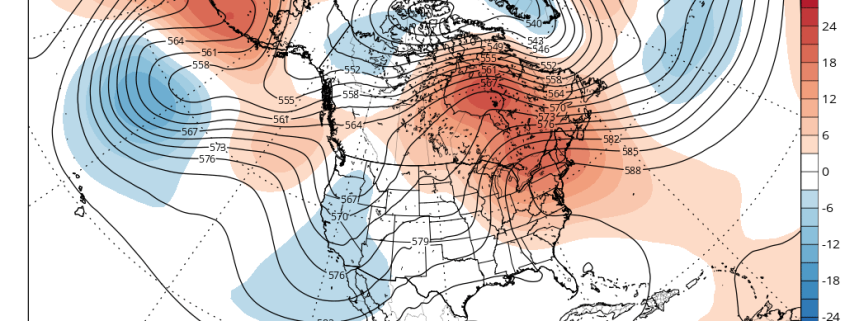
Over the past several months, our forecasters have monitored several extremely important variables, indices, and the trends in their behavior. We will be utilizing those variables and indices throughout our summer forecast. These variables reflect the atmospheric circulation patterns for certain geographical areas. For example, the AO refers to patterns within the Arctic Circle. The NAO refers to pattern characteristics in the North Atlantic, the PNA in the western part of North America, the PDO in the Pacific Ocean, and the EPO in the Northern and Eastern Pacific Ocean.

Typically, negative AO, NAO and EPO values correlate to enhanced high latitude blocking and high pressure to our north while lower pressure areas and troughs usually form underneath that high latitude ridging in the middle latitudes. In contrast, positive AO, NAO and EPO values generally yield lower pressure and less blocking to our north, while higher pressure and more ridging tends to build into the middle latitudes.

Read more

Premium Weekly Outlook 5/23 – 5/29: 80+ Degree Temperatures by Wednesday…More T-Storm Chances?

Some unsettled weather will start off this week with a cut-off low tracking in the region. But much warmer and drier conditions will finally arrive with temperatures soaring well into the 80s away from the shore by Wednesday and Thursday. The main question remains: will this warming trend to continue into the Memorial Day weekend, or is more cooler/ unsettled weather with showers and thunderstorms in store? We discuss more technical details and thoughts with the upcoming weather this weekly period.

So far — Monday began with plenty of sunshine as weak high pressure temporarily built into the region.  Despite a northeast flow, deep mixing will help temperatures today to rise in the middle to upper 70s.  This brings our temperatures to slightly above average for late May. Closer to the south-facing shores,  temperatures will be cooler with sea-breezes developing and pushing inland later this afternoon.

Read more

Coastal storm further south, some showers still possible

Most of the region is under overcast skies this afternoon with low pressure organizing along the Virginia or North Carolina coast.. We had anticipated a closer track to region with this storm with more rainfall today.. However latest models have this low tracking further south and east of the area. A balloon launched sounding over Brookhaven, NY this morning also showed very dry air and subsidence in lower to middle levels. This is causing rain from the southwest to evaporate or fall apart before reaching New York City metro area.

Clouds will still dominate rest of the day. Some showers are still possible with this afternoon and through tonight with the shortwave energy with the 500mb trough swing through region and coastal storm brushing the area. But heavy rainfall is no longer anticipated for the most of the region. For Mets fans, Mets vs Brewers game at Citifield later today should go with only a slight chance of rain delay from a shower. Visit our Sportcast page for more information.

Read more

Premium: Intricate phase will determine magnitude of coastal storm

The details of a phase between a mid level disturbance over the Ohio Valley, one with surprising vigor, and a second disturbance dropping southward from Southeast Canada into the Northeast, will have significant impacts on the eventual evolution of a coastal storm system this weekend. The atmospheric evolution in the mid and upper levels is actually quite complex, and reminiscent of some of the storm systems that impact our area in the winter season.

The pattern actually begins becoming amplified and energetic today (Friday), as a large trough in the Western United States amplifies. This will force a large ridge axis to build to its east, over the Central Plains states. This ridge drives northward, amplifying into Central Canada. This sets the stage for a large and amplifying trough over the Eastern United States this weekend.

Read more