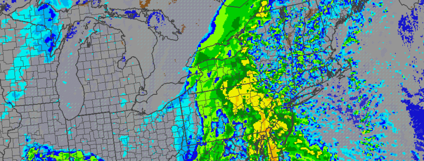
After bitter and record-breaking cold this weekend, attention turns to another storm for tomorrow. This will be a large, complex storm system that will impact the region starting at around Noon. Low pressure will organize over the Southeast United States on Monday, as high pressure slides out to sea. This combination will push a warm front northward through the Mid-Atlantic region during the day tomorrow. Light snow is likely to spread from southwest to northeast during the afternoon hours.
https://www.nymetroweather.com/wp-content/uploads/2016/02/18z4kmNAMradarTuesdayPM.png8191024Miguel Pierrehttps://www.nymetroweather.com/wp-content/uploads/2024/02/Empire-2000-x-300-px-2.pngMiguel Pierre2016-02-14 20:22:542016-02-17 10:20:46Large, Complex Storm Shaping up for Monday and Tuesday
The big debate among weather enthusiasts and meteorologists alike is whether NYC (Central Park) will hit zero or below tonight. This has not happened since 1994, and common opinion is that climate change along with the Urban Heat Island Effect would prevent NYC from ever going below zero again. While that thought process is not necessarily without merit, tonight is definitely the best shot NYC has had to go zero or below since 1994 — and perhaps should be even colder than the Arctic outbreaks from the past two seasons.
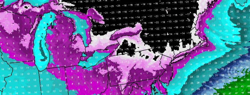
On February 20th, 2015, NYC got down to +2F, and on January 7th, 2014, NYC got down to +4F. There are certain criteria we look for to see how cold it can get in NYC: 1) 850mb temperatures, as they are a good indicator of the airmass, 2) Timing and degree of cold air advection — NYC due to the Urban Heat Island Effect does not cool off very much from radiational cooling, so they are very reliant on cold air advection, 3) Wind direction — generally a more northerly flow can more efficiently draw trapped colder surface air from the valleys, whereas a more westerly component has the tendency to downslope off the Appalachians and thus moderate somewhat when it hits us, and 4) Degree of mixing — if the surface air “mixes” with the airmass aloft, not as much cold air will be trapped at the surface, making it hard to truly go below zero.
https://www.nymetroweather.com/wp-content/uploads/2016/02/coldnyc7png.png8191024Doug Simonianhttps://www.nymetroweather.com/wp-content/uploads/2024/02/Empire-2000-x-300-px-2.pngDoug Simonian2016-02-13 17:52:592016-02-13 18:04:09(Premium) Comparing This Arctic Blast to 2014 and 2015
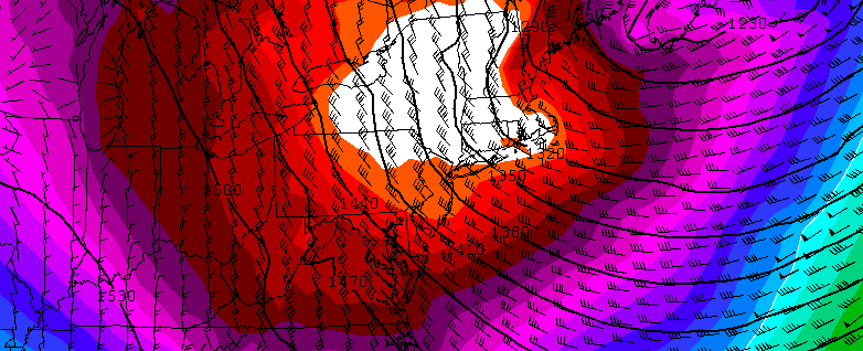
A piece or lobe of the Polar Vortex will swing south over the Great Lakes and Northeast. This supports an Arctic front passing through Friday night. Some snow showers or snow squalls are possible again tomorrow night with this front. Behind this front will be a potentially historic cold airmass for parts of Northeast. Saturday will see temperatures fall from the lower 20s to teens and single digits during the afternoon hours. Winds will also be increasing, as wind gusts between 30mph to 40mph are possible during the day. Thus, windchills will drop to near or below zero and may approach dangerous levels by Saturday evening.
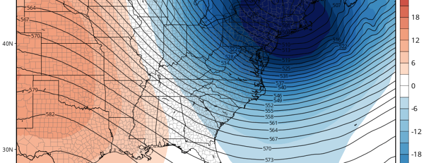
https://www.nymetroweather.com/wp-content/uploads/2016/02/gfs_z500a_eus_10-e1455211712126.png609800Miguel Pierrehttps://www.nymetroweather.com/wp-content/uploads/2024/02/Empire-2000-x-300-px-2.pngMiguel Pierre2016-02-11 13:13:112016-02-14 09:28:36(Premium) Record Breaking Cold Possible Sunday Morning… Another Storm Next Week?
A large arctic airmass, owing to a piece of the polar vortex, will drop southward late this week and weekend from Canada into the Great Lakes and Northeast United States. With it will come the coldest air of the winter — and the coldest air in quite some time, especially aloft. Temperatures at 850mb, or roughly 5000 feet, will drop to nearly -30 degrees celsius, challenging some records for temperatures at that level in the Northeast US for the date.
https://www.nymetroweather.com/wp-content/uploads/2016/02/Screen-Shot-2016-02-10-at-9.31.20-AM.png318782John Homenukhttps://www.nymetroweather.com/wp-content/uploads/2024/02/Empire-2000-x-300-px-2.pngJohn Homenuk2016-02-10 09:38:422016-02-10 09:38:42Coldest air of winter to arrive this weekend
Hi friends! Our website uses cookies to provide an optimal browsing experience for you. New "Cookie Consent" laws mandate us to inform you of this. As long as you're cool with it, just hit OK. You'll only see this message once.
We may request cookies to be set on your device. We use cookies to let us know when you visit our websites, how you interact with us, to enrich your user experience, and to customize your relationship with our website.
Click on the different category headings to find out more. You can also change some of your preferences. Note that blocking some types of cookies may impact your experience on our websites and the services we are able to offer.
Essential Website Cookies
These cookies are strictly necessary to provide you with services available through our website and to use some of its features.
Because these cookies are strictly necessary to deliver the website, refusing them will have impact how our site functions. You always can block or delete cookies by changing your browser settings and force blocking all cookies on this website. But this will always prompt you to accept/refuse cookies when revisiting our site.
We fully respect if you want to refuse cookies but to avoid asking you again and again kindly allow us to store a cookie for that. You are free to opt out any time or opt in for other cookies to get a better experience. If you refuse cookies we will remove all set cookies in our domain.
We provide you with a list of stored cookies on your computer in our domain so you can check what we stored. Due to security reasons we are not able to show or modify cookies from other domains. You can check these in your browser security settings.
Other external services
We also use different external services like Google Webfonts, Google Maps, and external Video providers. Since these providers may collect personal data like your IP address we allow you to block them here. Please be aware that this might heavily reduce the functionality and appearance of our site. Changes will take effect once you reload the page.
-2")